
[UPDATE 9:15 p.m.] Big Jump in Containment on the Six Rivers Lightning Complex!
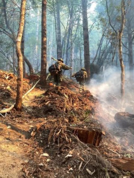
Six Rivers Hoselay Operation Div K Waterman Ridge Hose lay on the SRF Lightning Complex, Aug 12-15th.Photo courtesy of D. Anderson.
Almost nothing but good news today on the Six Rivers Lightning Complex. The estimated acreage of the fire dropped to 25,399 acres and the containment jumped to 67%. Residents have been allowed back into the densely populated areas of the Willow Creek and Salyer areas.
And for smoke choked residents along the northwest of the fires there could be some relief as wind clears the smoke this afternoon.
UPDATE 10:07 a.m.: Six Rivers National Forest reports,
Fire activity was minimal overnight with the cooler temperatures and increased humidity. Two spot fires developed on the northeast side of the Ammon Fire but were quickly contained by fire personnel in the area. Crews continued successful strategic firing operations and improved control lines using dozers and handlines to remove fuels. Control lines are holding well.
Campbell Fire
Crews will continue to strengthen fire lines and limit the spread of the main fire. Fire crews will patrol and extinguish remaining pockets of heat inside control lines on the west side of the fire.Ammon Fire
Firefighters will continue strategic firing operations along the southwest perimeter in the Friday Ridge area. Fire crews will work to ensure that the previous night’s spot fires on the northeast side remain fully contained. Crews will continue to improve and reinforce fire lines along the Six Road of Ammon Ridge and within the Friday Ridge System as well as along Titlow Hill Rd/Route 1 out to Highway 299.
UPDATE 9:17 p.m.: According to InciWeb, the Complex is now 25,733 acres and 73% contained.
Below we’ve gathered the most important information about the Six Rivers Lightning Complex Fire and organized it below for our readers and we’ll be keeping our eyes on what’s happening and updating throughout the day in green.
Stats:
Yesterday’s stats from Cal Fire are:

Today’s stats from Cal Fire this morning:

Note the reduction in equipment and personnel. There are 20 less engines, 2 less water tenders, and 132 less personnel.
The Plan:
The Weather:
InciWeb states, “Winds will be stronger about 10 mph in the afternoon…Winds should allow for good clearing on the north and west sides of the fire.”
The Roads:
Hwy 299 and Hwy 96 is open but please keep your eye on Caltrans QuickMap for the latest information.
The following roads into evacuation zones have been closed.
According to Six Rivers National Forest, the following roads leading to evacuation zones have been closed (residents may use these roads to exit only):
-
- Forest Route 7N15 at Six Rivers Forest Boundary
- Titlow Hill Road/Forest Route 1 after Horse Mountain Botanical Area. Because fire personnel and machinery will be building control lines for the Ammon Fire, residents are asked to limit travel on Titlow Hill Road/Route 1 in zones HUM-E052 and HUM-E062 to essential traffic only.
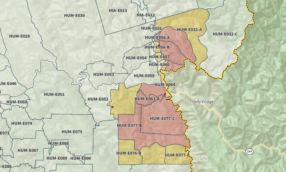
The Maps:
- Operations Map –to see details either zoom or click on the map and download a pdf.

- KMZ Map–Zoom for detail or for 3D imagery, click on the map and download a file that connects with your Google Earth program.

Evacuation and Meeting Information:
- Click here for the latest evacuation information from Humboldt County
- This is the latest Humboldt County Evacuation Map as of 8 a.m. on Thursday, August 18. However, click the map to go to the latest information on ZoneHaven.
- Click here for the latest evacuation information from Trinity County UPDATE 9:15 p.m.: As of 5:00 pm, the TCSO reduced the following area from an Evacuation Order to
 EVACUATION WARNING
Per the Trinity County Sheriff’s Office, the following area has been REDUCED to an Evacuation Warning- Ziegler Point Road / Forest Service Road 7N04.
EVACUATION WARNING
Per the Trinity County Sheriff’s Office, the following area has been REDUCED to an Evacuation Warning- Ziegler Point Road / Forest Service Road 7N04.
Earlier:
- Six Rivers NF Lists More Fires] Lightning Storm Peppers Northern Humboldt, Multiple Fires Reported
- Humboldt County Office of Emergency Services Issues an Advisory to Willow Creek Area After Multiple Fires
- Evacuation Orders Issued for Residents east of Willow Creek by HCSO and Evacuation Warnings Issued for Residents Near Salyer by TCSO
- Evacuation Orders and Warnings Expand as of 7:36 p.m. for Residents of the Willow Creek Area
- Over 500 Acres Burning Around Willow Creek This Evening as Latest Info on the Six Rivers Lightning Complex Released
- Six Rivers Lightning Complex Grows, Threatening Homes and Forcing Evacuations
- Trinity County Sheriff’s Department Issues Evacuation Orders For Areas Near Salyer
- New Evacuation Warning Issued for North of Willow Creek
- Humboldt County Issues New Evacuation Orders at 7:37 p.m.
- Six Rivers Lightning Complex Doubles in Size, 0% Containment
- More Evacuations Ordered This Morning as the Six Rivers Lightning Complex Takes New Ground
- Evacuation Orders Issued Sunday at 6:30 p.m.
- New Evacuation Warnings Issued Sunday by the Trinity County Sheriff’s Office at 7:52 p.m.
- HCSO Issues Evacuation Order for Zone South of Willow Creek
- Six Rivers Lightning Complex Expands to 6,773 Acres
- Six Rivers Lightning Complex Grows Several Thousand Acres and Is the Number 1 Priority in the State Right Now (PHOTOS)
- Steady Growth and New Evacuation Warnings: Six Rivers Lightning Complex August 10
- Six Rivers Lightning Complex Continues to Expand
- Firefighters Face Hotter and Drier Weather on the Six Rivers Lightning Complex Today
- Good News from HCOES
- Evacuate! New Order Issued on August 12 at 5 p.m.
- Trinity County Reducing Salyer From Evacuation Order to a Warning
- Law Enforcement Searching for Suspects in Willow Creek
- Law Enforcement Seeking Looters in Willow Creek
- Good News as Firefighters Claw Out 12% Containment on the Six Rivers Lightning Complex
- Captured! HCSO Arrests One Suspect in Yesterday’s Looting of a Property Under Evacuation Order
- ‘Secure and Hold,’ Firefighters Strengthen Their Grasp on the Six Rivers Lightning Complex
- Six Rivers Lightning Complex: 10 Days Nearly 20,000 Acres
- Six Rivers Lightning Complex Now the Second-Largest Fire in California This Year
- Storms Building in the Area of the Six Rivers Lightning Complex Today Worry Firefighters
- Six Rivers Lightning Complex Grows Almost 3000 Acres
Join the discussion! For rules visit: https://kymkemp.com/commenting-rules
Comments system how-to: https://wpdiscuz.com/community/postid/10599/
Good deal.
All that hard work paying off..
67% containment, wow way to go firefighters!!!! A drop in Engines, Water Tenders and Personnel. All those exhausting days and nights fighting the fire are paying off. The best news is that there were no firefighters killed. I will stand up and applaud all of you until my hands drop off!
Thank you so much. Every crew, volunteers, you are kicking ass. Sorry for the cuss word but you earned it
This is really good news. I took a little trip up 50 last week from Sacramento to Carson City and was utterly amazed at how many crews were mitigating fuel in the El Dorado Forest. Inmates, contractors and government personnel. Hundreds of them. How were they mitigating the fuel? Raking the forest. Chipping dead limbs and brush and getting it down to bare dirt. All along 50 and back into the hills.
Heartwarming to know that the federal government is taking care of our national forests.
But then again, many politicians, rich folk and celebrities have property around South Lake Tahoe. Perhaps this is just an example of the bourgeoisie ensuring their interests are protected.