
Pyrocumulus Cloud Forming Over the Hill Fire Early Today
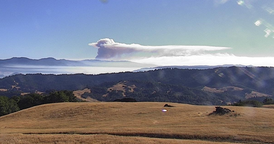
In spite of the expected moderate activity on the #HillFire, this morning, a little after 8 a.m., the fire began forming a pyrocumulus cloud. [Image from the Bald Jesse camera on the Alert California network]
Today, efforts are primarily focused on the northern side of the fire. Crews are working on constructing direct dozer lines and hand-lines south of Route 1. Firefighters are also conducting firing operations along Route 1 to enhance the fuel break between the fire and Friday Ridge.
The fire behavior is anticipated to remain moderate today under continued dry conditions.
CAL FIRE IMT 2 is in Unified Command with Six Rivers National Forest, coordinating the efforts to bring the Hill Fire under control.
We’ve gathered the most important information about the Hill Fire and organized it below for our readers.
The Plan:
Zeke Lunder, a wildfire technology specialist that we follow, does a great job explaining the fire situation overall in his video below. First he looks at the Hill Fire.
Cal Fire also gives a good overview of the fire situation in California and looks a bit into the Hill Fire.
Get an update on the #HillFire & other active fires in the state in today’s CAL FIRE Report. We also take a look at the upcoming weather heading into this weekend. Remember, 95% of wildfires are caused by people, so be sure you take steps to prevent them & stay #ReadyforWildfire pic.twitter.com/LYaPOtPipe
— CAL FIRE (@CAL_FIRE) July 18, 2024
The Weather:
The National Weather Service is reporting temperatures in the Seventies today over the fire. Overall the weather will be warm and dry through the weekend.
The Roads, etc:
Humboldt County says,
Humboldt County Public Works has closed the following roads:
-
-
- Harris Street at Hubbard Lane
- Hall Avenue at Myrtle Avenue
-
due to the activation of the CAL FIRE Incident Management Base Camp at Redwood Acres.
These closures will be in effect for at least the next two weeks.
Please use alternate routes.
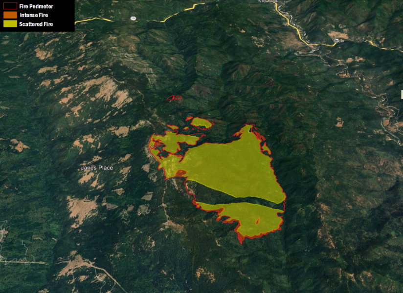
The Maps:
- Operations Map –to see details either zoom or click on the map and download a pdf.

- KMZ Map–Zoom for detail or for 3D imagery, click on the map and download a file that connects with your Google Earth program.
Evacuation and Meeting Information:
- Click here for the latest evacuation information from Humboldt County
Earlier:
- Lightning Activity Starts Fires in the Shasta-Trinity National Forest
- At Least 50 Lightning Strikes in the Six Rivers National Forest Cause Multiple Fires
- Evacuations as the Hill Fire South of Willow Creek Grows
- Hill Fire in Humboldt County Jumps to 3,437 Acres, 0% Containment
- Extreme Fire Behavior Possible on the Hill Fire Today Due to Weather Conditions
- Hill Fire Grows to about 4600 Acres, Still 0% Containment
Join the discussion! For rules visit: https://kymkemp.com/commenting-rules
Comments system how-to: https://wpdiscuz.com/community/postid/10599/
Thank you! So calm, comprehensive and clear and articulate.
Also shows how much thought and work goes on all year long in the past and what is being looked at for the future. Thank you to all involved. So impressive people dedicating their days to our ecosystem.
Lets remember that through 2028 atmospheric changes perdicted higher than normal temperatures globally. See Hunga Tonga volcanoe eruption.
Also China is messing about reducing the dust particles for western rainfall coming from the Taklamakhan desert