
[UPDATE 10:11 a.m.: New Evacuation Information] Hill Fire in Humboldt County Jumps to 3,437 Acres, 0% Containment
![Yesterday, smoke from the #HillFire formed a pyrocumulous cloud. [Image from the Bald Jesse1 camera in the Alert California network]](https://kymkemp.com/wp-content/uploads/2024/07/Hill-Fire-7.17.jpg)
Yesterday, smoke from the #HillFire formed a pyrocumulous cloud. [Image from the Bald Jesse1 camera in the Alert California network]
According to this morning’s map, there are multiple large spots that have jumped out to the northwest of the fire.
According to the Northern California Geographic Coordination Center, yesterday,, the Hill Incident had “Extreme fire behavior with long-range spotting and short crown runs observed.”
Multiple structures are threatened and the Humboldt County Sheriff’s Department issued both an Evacuation Order and an Evacuation Warning for zones in the area (See Evacuation Information below for more.)
The ONCC warns, “Powerlines, communication infrastructure, Private timberlands and critical wildlife habitat is threatened.”
Trinity County Sheriff Tim Saxon told KMUD News this morning, “We are closely monitoring the situation regarding the Hill Fire along with Humboldt County and Trinity County OES. At this time, there are no anticipated Warnings or Evacuation notices based on the current fire activity. However, as always, people should be aware of their individual circumstances and voluntarily leave an area if they feel uncomfortable.”
We’ve gathered the most important information available at this time about the Hill Fire and organized it below for our readers.
Compelling Images:
https://www.facebook.com/NWSEureka/posts/pfbid02uxGg2sw8ZoJEKxjr3Z8pkXBafxu7aX3WHBamZ2toB6BbakXKEmrxWZjRA9ioUzB9l
#HillFire in #Humboldt County, CA, our #wildfire monitoring solution detected first hotspots with low FRP levels & spread rate, but conditions changed and it took off. Shows the importance of keeping 24/7 neal-real time observation of #wildfires. pic.twitter.com/dmhtl7pIQo
— Steve Maisonet (@Steve_Maisonet) July 17, 2024
The Weather:
The National Weather Service in Eureka is predicting temperatures in the mid 80’s today
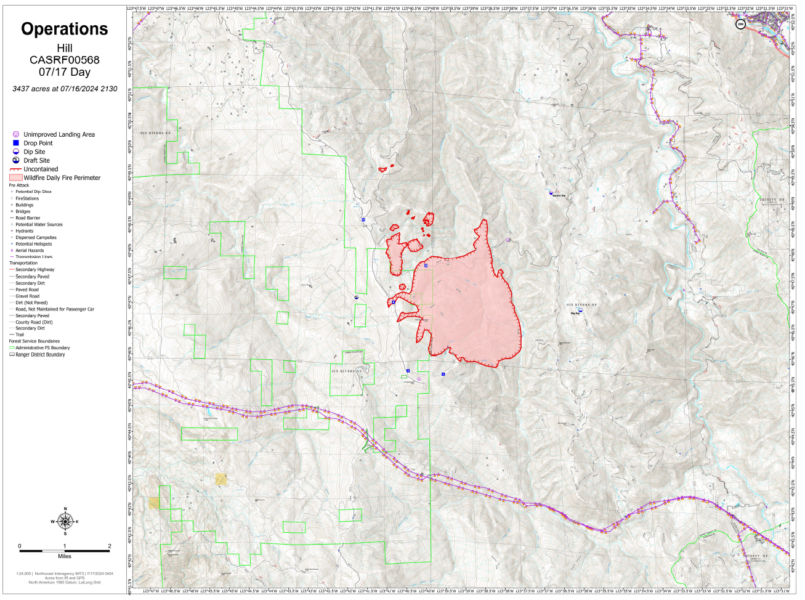
The Maps:
- Operations Map –to see details either zoom or click on the map and download a pdf.
Evacuation Information:
- Click here for the latest evacuation information from Humboldt County Sheriff’s Department and Humboldt County OES and the Genasys Map.
- As of last night:
Mandatory Evacuation Orders have been issued for the following zones. Leave now!
-
-
-
- HUM-E077-A
-
-
Evacuation Warnings have been issued for the following zones. Be prepared to leave!
-
-
-
- HUM-E077-B
-
-
UPDATE 9:53 a.m.:
Lauren Schmitt of KMUD News spoke to Matthew Kiddwell, lead meteorologist, with the National Weather Service in Eureka. He gave her the following information:
Weather & Fire Behavior:
Over the last few days, winds from the south have pushed the smoke and fire northward. However, this will change this afternoon and Thursday, with winds shifting to come from the northwest. These winds are forecasted to be around 10-15 mph, with nothing particularly strong even on the ridges. On Friday, winds could increase to 10-20 mph.
Temperatures are expected to be relatively cool through the weekend, ranging in the 80s and 90s. By Sunday or Monday, temperatures could rise back into the 100s.
Satellite imagery still shows smoke because the fire has been burning actively overnight at a higher elevation above the fog line. The fire is currently progressing into a fire scar from a 2022 lightning complex which should help to slow its progress.
UPDATE 10:11 a.m.: There are new evacuation information that just came out.
According to the Humboldt County Sheriff’s Department,
HILL FIRE UPDATE Effective July 17, 2024 at 9:45 a.m.
EVACUATION ORDER Issued for Zone HUM-E077-A: Due to the Hill Fire, the Humboldt County Sheriff’s Office has issued an immediate evacuation order for zone HUM-E077-A North of White Oak Creek/Grouse Creek, South of Friday Ridge Road, Forest Route 6N08A, East of Titlow Hill Rd, Twin Lakes Creek, West of Mosquito Creek/Madden Creek. Those in this zone should leave now for their safety.EVACUATION WARNING: Due to the Hill Fire, the Humboldt County Sheriff’s Office has issued an evacuation warning for zones:HUM-E077-B North of PG&E Road, Grouse Creek, South of Madden Creek, Forest Route 6N06, East of Mosquito Creek/Madden Creek, West of Trinity County Line.HUM-076-A North of Friday Ridge Road, South of Upper Ranch Road/High Prairie Road, East or Redwood Creek, West of Forest Route 5N01.Prepare for potential evacuations, including personal supplies and overnight accommodations. Those in this zone should prepare to leave at a moment’s notice. More information will follow if an evacuation order is issued.ROAD CLOSURES: Road closures are in place at Friday Ridge Road at Forest Service Route 6N06, Friday Ridge Road at Forest Route 5N01, and Friday Ridge Road at Forest Route 5N04.Conditions are subject to change at anytime. Please visit protect.genasys.com for a full zone description. For more information call 707-268-2500 or go to humboldtsheriff.org/emergency.Sign up for Humboldt Alert emergency notifications at humboldtgov.org/alert.For more information, call 707-268-2500.
Here’s a map with the newest evacuation information at this time. BUT click on it to be taken to the latest map from Genasys.
Earlier:
- Lightning Activity Starts Fires in the Shasta-Trinity National Forest
- At Least 50 Lightning Strikes in the Six Rivers National Forest Cause Multiple Fires
- Evacuations as the Hill Fire South of Willow Creek Grows
Join the discussion! For rules visit: https://kymkemp.com/commenting-rules
Comments system how-to: https://wpdiscuz.com/community/postid/10599/
holy embers!! be safe fire fighters!!
????? thank you!!!
USFS did a fire-suppression clearing on Forest Highway 1 couple years ago.
They should be able to hold it on the east side of the road.
If it goes north along the east slope it will take out most of the (remaining) Port Orford Cedar stands.
The furthest south stand of Port Orford Cedar that exists, that is. I’m sure it’ll be ok. Fires have happened before.
Thank you to KMUD, RHBB, and Trinity County Sheriff Tim Saxon for this important Trinity County evacuation warning and evacuation order status update…
…………….
“Trinity County Sheriff Tim Saxon told KMUD News this morning, “We are closely monitoring the situation regarding the Hill Fire along with Humboldt County and Trinity County OES. At this time, there are no anticipated Warnings or Evacuation notices based on the current fire activity.”
………
And also, thank you, for this important weather shift forecast update…
………
‘Weather & Fire Behavior:’
“Over the last few days, winds from the south have pushed the smoke and fire northward. However, this will change this afternoon and Thursday, with winds shifting to come from the northwest. These winds are forecasted to be around 10-15 mph, with nothing particularly strong even on the ridges. On Friday, winds could increase to 10-20 mph.”
…………
Hopefully this will assist the firefighters push the fire back into areas it has already consumed, and will help to extinguish it…
Stay Safe Everyone…!!!
Faack this is getting old
It is too bad the leadership won’t dump a few billion dollars into fire fighting and fire prevention. We could have some amazing technology and capabilities. Thank you Firefighters for doing what you do with what you have.
I agree 100% with your comment Rick! All the firefighters are working in hell on earth, and I pray we don’t lose a single one.