
[UPDATE 11:50 a.m.: Weaverville and More Under Evacuation Warnings] Monument Fire Roars Over Another 22,000 Acres in the Last Day
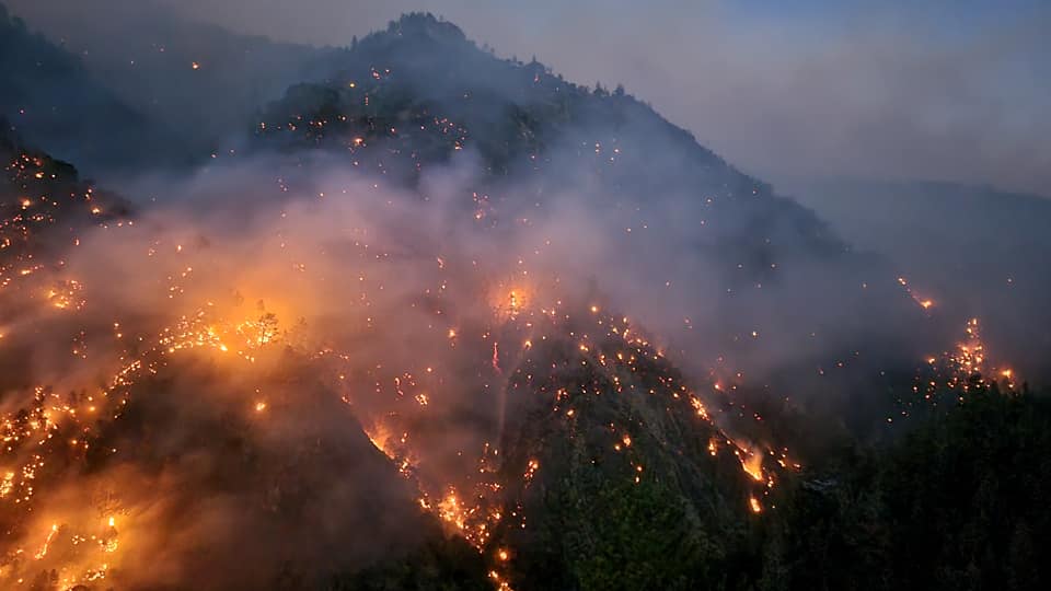
The Monument Fire burning on Ironsides Mountain. [Photo taken last night from from the big turnout at McDonald’s Bluff kindly provided Hawkins Bar VFD]
The Monument Fire grew an explosive 22,000 acres last night mostly to the east towards Junction City and the southeast towards Hayfork forcing new evacuations yesterday. The fire remains at 10% containment, but yesterday was rough especially in the Red Hill area where flames were active and residents fled down roads lined with flames.
According to Operations Section Chief Alex McBath, spokesperson for the team fighting the fire, crews “saved a lot of structures” in the Red Hill to Hwy 299 area. He also said there was a 10 acre spot fire that was on the east side of the Trinity River above Sky Ranch that crews will be looking at today. He pointed out spot fires and pushes from the main part of the Monument Fire were running towards Hayfork and Barker
According to the Shasta-Trinity National Forest Public Affairs Office,
The fire remained active throughout the night and significant growth occurred to the east and southeast flanks. Crews were confronted with gusty, northwest winds that continued to transport firebrands ahead of the fire front which supported the increase to 119,280 acres. The fire remains at 10% contained. Firefighters combated the spot fires and took aggressive action to defend structures and provide point protection for Junction City and surrounding residences. The fire spotted north of SR-299, however, crews were able to access the area and get line around the spot fire.
Firefighters continued to hold and patrol existing fire line on the western edge of the fire, continually mopping up smoldering hot spots.
Today, crews will focus their efforts on life safety, defending property and critical infrastructure in communities threatened by fire, specifically in and around Junction City as northwesterly winds are again forecast. Firefighters will continue to bolster and strengthen new and existing contingency lines and engage in point protection of the values of risk.
Fire on the northwest side of the Trinity River will remain active today as it is expected to continue to back down drainages. Crews are assessing the fire’s progress and contingency operations are taking place along the Denny Road.
We’ve gathered the most important information about the Monument Fire and organized it below for our readers.
Stats:
911 Total personnel, 12 hand crews, 77 engines, 6 helicopters, 13 dozers, 6 water tenders, 6 masticator
Compelling Images:

The Monument Fire burning on Ironsides Mountain. [Photo from Hawkins Bar VFD]

The Monument Fire burning on Ironsides Mountain. [Photo from Hawkins Bar VFD]
![Firefighter on the Monument Fire. [Image from the Shasta-Trinity National Forest Service]](https://kymkemp.com/wp-content/uploads/2021/08/MOnument-Shasta-Trinity-8.16-post.jpg)
Firefighter on the Monument Fire. [Image from the Shasta-Trinity National Forest Service]
The Plan:
![Firefighter on the Monument Fire. [Image from the Shasta-Trinity National Forest Service]](https://kymkemp.com/wp-content/uploads/2021/08/MOnument-Shasta-Trinity-8.16-post-the-plan-.jpg)
Firefighters making plans on the Monument Fire. [Image from the Shasta-Trinity National Forest Service]
Informative Accounts:
Hawkins Bar Fire Chief Todd Wright’s post about the Monument Fire from last night.
Just got back from Burnt Ranch, to take a look at the progression on Ironside. Fire is down to the river in areas between the dump and McDonald’s Bluff, and there it is being patrolled all night in case it jumps, It’s quite the view to look at.
Moving West, what everyone one is seeing from Salyer and Hawkins Bar, is still on Ironside. It made a pretty decent run toward the New River today, but it’s still not there. I promise, you will know when it does, there are people with eyes on it 24/7 right now.
Had a quick chat with some personnel, and it sounds like it spotted over some line up top of the 60 Rd, Underwood Mtn Rd, but crews were able to pick them up, or were actively engaged at the time of this post, including Hawkins Bar Water Tender 4142.
Engine 4123 was, and will likely again be the lookouts for 299 making sure if it jumps, there are crews and aircraft on it right away.
Back on the Engine tomorrow, everyone sleep well knowing there are crews out there watching out for us right now, and will be 24/7 as long as a threat exists.
The Weather:
According to the Shasta-Trinity National Forest Public Affairs Office,
Northwest winds will develop over the fire, with gusts up to 35 mph along the ridge tops and up the Trinity River Canyon. Overnight the winds decreased, but remained gusty along the ridge lines. Starting at 1pm today, a Red Flag Warning will be in effect over the area and is expected to bring more northwest winds along with hot, dry conditions.
The Roads:
Hwy 299 remains closed.
The Maps:
- Operations Map –to see details either zoom or click on the map and download a pdf.

- KMZ Map–Zoom for detail or for 3D imagery, click on the map and download a file that connects with your Google Earth program.

Property Damage Assessment:
This remains reported at the same amount as earlier. See below. But there may be more as yet undocumented.
Damage assessment teams have confirmed 32 structures have been destroyed. For questions or information regarding the status of your property, call Trinity County Office of Emergency Services (OES) at 530-623-1116.
Evacuation and Help Information Including Community Meetings:
- Evacuation Centers are at
- The American Red Cross is opening a shelter for #DixieFire and #MonumentFire evacuees at Shasta College, 1155 Old Oregon Trail, Building 1900, #Redding, CA.
- Evacuation Center on western side of the fire:
Trinity Velley Elementary School, 730 California 96, Willow Creek, CA 95573
- Areas under Evacuation Warning are
- areas north of SR 3, from Wildwood to Hayfork Summit
- Areas under Evacuation Order are:
- Barker Mountain
- Big Bar
- Big Flat
- Burnt Ranch
- Canyon Creek
- Cedar Flat
- Coopers Bar
- Del Loma
- Areas Northwest of the Hayfork Summit (See here)
- Helena
- Junction City east to Oregon Summit including:
- La Grange Road,
- Castle Road
- Slattery Gulch Road
- Red Hill
- Sky Ranch Road
- Anyone impacted by Wildfires in Trinity County can receive free referral support, group support, and one-on-one crisis intervention by reaching out to (530) 461-0257 and [email protected].
- According to the Trinity County Animal Shelter, “If you are being evacuated and need help moving or a place to take large animals please call either the sheriffs office at 530.623.2611 or us here at the shelter at 530.623.1370.” More information here: Animal Shelter Evacuation Information From the Trinity County Sheriff’s Department In addition, Domestic + Large Animals can be taken to the Hoopa Rodeo Grounds on Pine Creek Rd in Hoopa, CA. Click here for a map.
- Mandatory evacuations caused by fast moving wildfires in the local area have resulted in the temporary closures of several Trinity County Post Offices. Customers impacted by these closures may pick-up mail at alternative locations. See details below:

Earlier Chapters:
- Evacuation Warnings Issued for Del Loma Area Along Hwy 299; 1000 Acres and 0% Contained
- Hwy 299 Closed at Big Bar Due to the Monument Fire
- Hwy 299 Reopens, But ‘Subject to Closure at Any Time’
- Trinity County Sheriff Issues Evacuation Orders Tonight in Big Bar Area as Monument Fire Grows; Hwy 299 Closed!
- Breakout Spots From the Monument Fire Crossed 299 and Trinity River, Threaten Structures
- [UPDATE 6:52 p.m.: Monument Fire Now 9000 Acres, 0% Contained] Evacuation Order for Cedar Flat and Evacuation Warning for Burnt Ranch Areas Along Hwy 299
- Monument Fire’s Behavior Causes Sheriff to Issue Evacuation Warning for Big Flat
- Monument Fire Grows Another 6000 Acres, Now at 15,000 and 0% Contained
- Monument Fire Grows Over 2500 Acres Today
- About 240 Customers Without Power as the Monument Fire Continues to Disrupt the Lives of the Small Communities Along Hwy 299
- Monument Grew Another 7000 Acres to Almost 25,000 and Remains Uncontained
- Evacuation Warning For Helena, Junction City, Coopers Bar, Red Hill, and Canyon Creek
- Trinity County Sheriff Issued an Evacuation Order for Big Flat
- Monument Fire: New Evacuation Orders and Warnings as Fire Ramped Up Activity Today
- Structures in the Tiny Tourist Town of Big Flat Burned as Monument Fire Swallows Another 10,000 Acres, Still 0% Contained
- Trinity County Sheriff’s Office Issues Evacuation Order for Helena
- Monument Fire Grows to 42,567 Acres, Still 0% Containment
- Spot Fire Northwest of Junction City
- Monument Fire Just Under 50,000 Acres and 0% Contained as It Spread Quickly Overnight
- Monument Fire Surpasses 50,000 Acres
- Evacuation Order Issued for Burnt Ranch Area
- Temporary Evacuation Point Set Up for Evacuees From the Monument Fire
- Monument Fire Captures Just Under 58,000 Acres, Firefighters Hold at 3% Containment
- Thirty-One Structures Destroyed so Far as the Monument Fire Takes 62,490 Acres
- After a Night Where the Fire Grew a Mile to the East in One Area, Red Flag Warning Will Challenge Crews Battling the Monument Fire Today
- Red Flag Conditions Again Today as Monument Fire Closes in on 75,000 Acres With Only 5% Containment
- Monument Fire Swells Another 4000 Acres; Containment Remains at 5%
- Wind and Hot Dry Temperatures Could Challenge Crews on the Monument Fire Particularly on the East Side Today
- The Trinity County Sheriff’s Office Issued an Evacuation Order on the Monument Fire for Sky Ranch Road
- Leaping Almost 15,000 Acres Since Yesterday, the Monument Fire Closes in on 100,000 Acres
- As Monument Fire Grows, Trinity County Sheriff’s Department Issues an Evacuation Warning for Wildwood Road to Hayfork Summit
- New Evacuation Orders Issued on the Monument Fire (MAP)
Join the discussion! For rules visit: https://kymkemp.com/commenting-rules
Comments system how-to: https://wpdiscuz.com/community/postid/10599/
Thank you for coverage that gives a lot of information.
I’d co,mment more but my head is about to pop off. thanks
Thank you for the local update!! Stay safe All!!
Just got a call from TCSO, stating an evacuation warning for all areas East of highway 3,from Hayfork Sunmit to 9 mile bridge on Hyampom Road.
That’s all of Hayfork.
My wife read on FB (veracity warning!) That Weaverville and Doglas City are under warnings as well.
Here’s the entire warning: https://kymkemp.com/2021/08/17/trinity-county-sheriff-puts-large-swaths-of-trinity-county-under-evacuation-warning-as-monument-fire-faces-a-day-of-dangerous-fire-weather/
thank you!
Bless the firefighters….
Thanks for excellent coverage.
A big shout out to Todd Wright and the Hawkins Bar Volunteer Fire Department!
Thank you for your hard work and excellent communication
Thanks Todd, keep up the good work.
Is there anywhere in Humboldt County to evacuate, besides Willow Creek? My parents are in Weaverville and are 85 & 80 years old. I hate to see them in a shelter with Covid so bad. If anyone has someplace I could rent? I can’t afford motel rates.
Contact Humboldt Office of Emergency services, they may know of discounted rates for evacuees who are more vulnerable to covid.
Best of luck!
Ger them somewhere soon before the 3 closes, the coast has had less smoke.
I also have family member who is in her 90s and lives alone in Weaverville on Taylor st. I can’t get through by phone and am afraid she won’t get the get out order or has not even gotten the get ready order
This isn’t an Evacuation Order. This is just a warning.
Dang, get ready everybody! Today is possibly last chance to get supplies in or out. Don’t wait any longer.
To be extra cautious have someone come to you. If you’re outside the evac area when the order comes you’ll be stopped from going in. Evac order will come early in mornings based on recent policy.
Real (not Covid) lockdown coming!
The Hoopa Rodeo grounds are not in Willow creek, they are in Hoopa. Miles from there. This Info posted may confuse people evacuating with large animals..
Ice, thank you! I had just copied the information from InciWeb and assumed they would have a correct address. I’ve fixed that now and added a map link. I appreciate you helping me get clearer.
Thank you, Kym, for your diligent reporting! I’ve been following this fire closely. I have many friends in Willow Creek, and a good friend in Burnt Ranch whose property is now part of the burn scar.
I am so sorry for your friend. That is brutally hard to lose your place.
I would imagine that many of the areas are what we would call “in the black” as the damage has been done and the fire moved on. Such as , Del Loma, Big Bar, Big Flat. Perhaps others. I know of people who didn’t leave and I’m wondering about their wellness. Michael Shreeve, Down River VFD formerly, Raft Guide Kayaker ect. Now in the Redding Area. I received my Cal Fire Hazmat Certification from a training at the Hawkins Bar VFD. I’d love to hear more about conditions inside but communications are completely down, other than repeater at Hayfork Bally (Amateur Radio) which was saved with the others. I wish and I’m sure the people inside the fire wished they had ham licenses now ! I’d love to hear from them.
Thanks for thinking of us, conditions for those of us who have stayed are made exponentially more difficult and stressful by the lockdown status and harassment of local property owners maintaining lives and businesses inside. There are many, MANY of us who responsibly faced the fire and protected our lands, families and neighbors.
Trinity County is blessed with some of the truest-hearted, capable individuals in the world and I am proud to call them neighbors.
As for the fire itself, stumps and roots are still burning 2 weeks after in areas where the trees are all dead now and could cause issues if they flared up.
There is an abundance of Contractors roaming in and out.
Some are truly just killing time waiting for instructions from an absent or remotely based supervisor.
There are millions and millions of dollars worth of heavy equipment parked along the highway but it really seems like there is very little concern for mopping up and getting back to normal.
I am seeing , besides a mapping plane, an air attack plane. quite high in elevation, too high to be doing anything but talking to the mapping plane and maybe the ground . 240 was there. Love that plane.
I hope they put most of the fire suppression around the Josh house. It’s the coolest museum anywhere in this country. It took a cheese burger to get me to town but it was a stop at the museum my kids wanted
I pray weverville will stay safe. And the Nugget. Bets egg cook in the land works there.
Nugget building in foreclosure and is falling apart. Tree landed on it last week. It might be better off burning, if there’s sufficient insurance.
Just for information the Joss house evacuated the items inside a couple weeks ago so it could be done safely and then returned safely if the fire gets that far we’ll see if the building survives but the most important things were on the inside as they do tell the story. Was incredibly smart move for them to do that when there was not a talk of a possibility of the fire reaching that far they just chose not to take the chance and they were right to do so bravo
Fucking let cal fire do their job!!!! Fucking FEDS!!!!!
Like they’re doing on the Dixie fire? You have no clue what you’re talking about. Just take some time to see the difference in the areas (topography, road access, urban interface, etc.) that are CalFire protected lands and USFS protected lands. After some research you may see why sometimes they maybe a little more successful than the Feds. So sick of comments like this.
It just Forest miss management. Common sense went away years ago. Us old loggers no never went to college we just knew how to get it done. It’s too easy to blame it on global warming. One look at the Hayfork ranger service station before the fires said it all. There used to be fire camps all over the woods that were men with firefighters. It was rare for a fire to get out of control