
[UPDATE 11:52 a.m.: Map] Evacuation Warnings Issued for Del Loma Area Along Hwy 299; 1000 Acres and 0% Contained
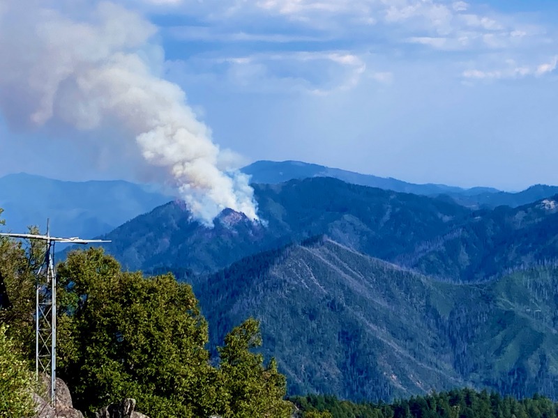
Monument Fire (Formerly called the Panther Fire) yesterday afternoon. [Photo provided by a reader and taken from Ironside Mt Lookout station]
The Monument Fire (formerly the Panther Fire) was ignited by lightning on July 30 at approximately 6pm. It is located approximately 1 mile south of Del Loma on the U.S. Forest Service – Shasta-Trinity National Forest. It was mapped by infrared at approximately 800 acres last night and has grown to about 1000 acres this morning and is 0% contained. Growth yesterday and overnight was primarily to the east. It is staffed with ground and air resources. The Trinity County Sheriff’s Office issued evacuation warnings for structures on both sides of the Trinity River near Del Loma along Highway 299 at approximately 10pm last night. A Type 1 Incident Management Team has been ordered for the Monument Fire.
For More Information, including downloadable maps and updates:
Inciweb:https://inciweb.nwcg.gov/incident/7750/
Twitter: @ShastaTrinityNF
Facebook: @ShastaTrinityNF
Email: [email protected]
Fire Information Line: (530) 628-0039 (8 am to 8 pm daily)
UPDATE 11:52 a.m.: Map

Heat outline of the Monument Fire taken at 5:40 a.m. today.
Click for a downloadable version of the map that works with Google Earth.–HeatPerimeter
Join the discussion! For rules visit: https://kymkemp.com/commenting-rules
Comments system how-to: https://wpdiscuz.com/community/postid/10599/
“Primarily moving to the east”, or whatever the direction may be, is good info.
Kym,
Can you transfer Ullr Rovers links from the previous thread to this thread?
If you can, could you please?
Thanks.
The maps one is especially cool
In the photo provided by the reader, can anyone answer if the very tallest and furthest peak pictured is Barker Mt.?
That should be Hayfork Bally, Brian. Stay safe, it’s telling that a type 1 IC has been ordered. These fires typically want to burn up to the divide, but will be influenced by late night / early morning winds from the east and late afternoon winds from the west down the river corridor. Hopefully it’s still damp around you and the surrounding landscape. The nights should be cooler, and by Wednesday the highs will be in the low 90s. Lots of aircraft overhead going downriver.
They’ve only run spotter planes since early afternoon yesterday. The Air Force flew their C130 by so maybe they’ll come back for a drop, but it looks like they’re setting up for the long haul on this one.
Thanks Erik,
I’m at the Divide, and in a week or so I’ll know if I want a new pair of pants….
I think it’s Hayfork Bally.
Great info, Ullr Rover, and Erik.
Very impressive. Local knowledge, there is no substitute.
I was wondering the same thing about the peak in the background behind the smoke, TRB.
Thanks for asking the question, The Real Brian, it was a good one.
I hope it misses you all.
Stay safe.
Thank you, I think you’re right.
IR map
https://maps.nwcg.gov/sa/#/%3F/%3F/40.7801/-123.3602/14
It’s 7-8 hours old now. I’m sure they won’t update until overnight.
I’m pretty sure the picture above is from Ironside lookout, for reference.
Ullr Rover,
Nice work.
I had to check the time stamp to see if you beat me to it again.😁
The maps one is pretty cool.
Stay safe.
Thanks. I posted it in response to your comment.
I appreciate that. I hope I’m not the only one.
It’s very useful. I thought it might be useful for your community.
I’m no good with the link thing, so I did need help with it, I tried to post it, but it disappeared. The funny thing is, the request posted.
I’ll try again for practice,
Monument Fire, (Formerly The Panther Fire),
https://maps.nwcg.gov/sa/#/%3F/%3F/40.7562/-123.3602/14
The emulation is a compliment.
I see that it worked this time,
And it wasn’t that tough.
I think I left off the /14 at the end the first try, and when that didn’t work, I just gave up.
Thanks for your efforts,
Ullr Rover.
Yes, it is from Ironside. I’ve updated the caption now to reflect that.
“Ryan Hutson”,
Am I feeling a “slight” chill?
Might want to add “Monument Fire,(Formerly Panther Fire)”, to the headline, too?
You know, just pass it along?
Just a suggestion.
Thought it might be pertinent.
Hat tip to Ullr Rover.
On a Sunday morning, even.
That’s worth double.
He would make a good reporter, if you’re in need of an extra.
He’s on it.
And he’s got the Triple A links at the ready.
All of them.
That’s the best.
And, he doesn’t leave you hanging, let alone, leave you hanging out to dry.
That’s the worst.
What’s the three most important things in the fire service?
Communication, communication, and, communication.
That’s Fire 101.
It doesn’t matter if you don’t like each other or not, save that for when there is no one on the line.
Then, after the incident is over, go ahead and go back to giving each other the cold shoulder.
I’ve got family in harm’s way of the Monument Fire, (formerly the Panther Fire).
In the 2008 Panther Fire in the same area, there was an entrapment fatality.
I don’t appreciate the silent treatment during a hazardous incident.
It seems personal.
Very unprofessional.
Vindictive even.
Clannish is bad enough, and that is on a good day.
“WTF”?
https://www.arcgis.com/home/webmap/viewer.html?webmap=df8bcc10430f48878b01c96e907a1fc3
I think this is a more useful map.
Pretty cool, other guest,
But more useful?
I didn’t think so at first, but maybe it is.
Additionally useful, to be sure.
It definitely gives the bigger picture.
I combined information from the picture, the fires direction of travel in the report, East, your map link, and the reference to the photo being taken from Ironside Mt., The smoke plume in the photo, assuming it was going East the reference to Hayfork Bally, and of course I must give credit to TRB for the Triple A question, to orient myself, and find Ironside Mt., and then dead reckoning to find Hayfork Bally.
(6200’+-)
Pretty cool. Thanks everyone.
Oregon mountain alert cam looking west:
http://www.alertwildfire.org/shastamodoc/index.html?camera=Axis-OregonMt&v=81e002f
Hayfork bally alert cam looking west:
http://www.alertwildfire.org/shastamodoc/index.html?camera=Axis-Hayfork&v=81e002f
Both cameras are co-located with a second camera that is typically pointed at the McFarland fire. Use the map to switch.
Bird’s eye view:
https://www.star.nesdis.noaa.gov/GOES/sector_band.php?sat=G17§or=pnw&band=GEOCOLOR&length=24
USFS indicated they’re going to contain the Monument Fire in the 2008 Cedar Fire lines. I did a rough overlay of the fire in that zone. Blue is the new fire. This gives you an idea of what to expect with how they are going to manage it.
…
USFS indicated they’re going to contain the Monument Fire in the 2008 Cedar Fire lines. I did a rough overlay of the fire in that zone. Blue is the new fire. This gives you an idea of what to expect with how they are going to manage it.
..
….
Sorry about the duplicates… your site was being obtuse.
Ullr Rover,
That is pretty scary if they are expecting a repeat from 2008.
I guess 13 years is a lot of time for things to grow back.
Thanks for the cutting edge graphics.
Did you use to fly a spotter plane?
Your like a spotter plane.
Way ahead of the pack.
They’re using the Cedar Fire part of the 2008 complex. The Cedar Fire was just part of the larger complex. A lot has grown back. In the heavier burn scars the brush is impassable.
This has a link to the pdf with the full operations map if you want to put in scale.
https://twitter.com/sparky_chief/status/1421916034324320257?s=19
There is no intention to put this fire out work is picking up now for the forest circus it will burn tell the rains come back #fireisabusiness
Yup. I saw that when they pulled air resources off of it yesterday.
A slew of tankers on it now.
It looks like they are trying to keep it north of the divide so it does run into Corral Bottom.
Forest Service Firefighters make like 14 an hour
But sure they’re all in it for the money
We need better school systems out here, apparently
Hand crews make chump change. The whole wildland firefighting apparatus is a multi-billion dollar industry.
It was almost criminal, they pulled the resources off knowing the afternoon winds were coming and didn’t fortify the east side. Watched it grow from the initial strike and you can tell they had no serious intention of stoping it. Now many small communities will be threatened.
You realize there was another fire literally right next to Burnt Ranch, right? Underwood fire.
But naw the forest service is totally letting it burn on purpose to destroy the towns in their forest because garble garble gobernment evil
There was another fire right next to a bunch of houses on Underwood mountain that took resources from the panther fire
Nah. That’s not what happened. I was watching air traffic at the time. The Underwood fire was held at 2 acres. One chopper and guys on the ground did that one. The monument fire was out of reach for ground crews. Air attack was pulled to higher priority fires. It’s not a conspiracy. It’s business.
Forest service fucked this one up for sure.
All these fires suck! But fighting that fire up on the mountain side with no road access does put lives at risk. Letting it burn to the dozer lines isn’t the craziest thing I’ve heard of the Forest Service doing. lol
Other Guest , those afternoon winds could make flying tankers in the mountains more dangerous than it already is.
I’m all for keeping the pilots safe.
And there must be a bunch of fires they are addressing.
As long as they are protecting the homes and people, that all we can ask of them.
Reminding everyone about Broadcastify
https://www.broadcastify.com/listen/stid/6
Click on your county in ca.
Tossed this together real quick, it has the Trinity County Burn History over the 2020 NAIP aerial imagery, the burnt orange fire perimeters represent 2000 – 2009 fires, mostly 2008, which is when the Cedar happened. The image is compressed AF so the fire labels may be illegible. The Monument heat perimeters are shown red with a yellow outline. Reddish perimeters are more recent fires, lighter colors are older going back to 2010. I made a pdf as well, not sure how to post it.
RUN FOREST RUN people don’t hesitate get the hell out to safety remember the past fires.
[…] [UPDATE 11:52 am: Map] Evacuation Warnings Issued for Del Loma Area Along Hwy 299; 1000 Acres and 0%… Redheaded Blackbelt […]
Burning to N to the river, moving E as well, but didn’t seem terribly fast in the E direction. Lots of air support until +/- 7:30pm. Cal Trans worker said to anticipate 36 hour closure on 299. Pic is CB bridge looking W at +/- 10:30pm You Dub is open…
Best current map. 3100 acres
https://mappingsupport.com/p2/gissurfer.php?center=40.746426,-123.333549&zoom=12&basemap=ESRI_scanned_topo_USA&overlay=VIIRS_24_hours,MODIS_24_hours,State_boundary,Wildland_fire_name,Fire_perimeter_NIFC,ESRI_roads_and_labels&fire=CA,Monument&data=https://mappingsupport.com/p2/special_maps/disaster/USA_wildland_fire.txt
This was the wildwood plume last night around 8.
Unfortunately the smoke was obscuring the plume from the much closer Monument.
Sheesh
From Hayden Flat
I see a massive plume by junction city/helena.Is there a new start or did the monument travel 18 miles overnight?
(I’m driving up to view now, it may be a plume drift from monument…know more soon)
**the smolders in the Alps has EXPLODED.
There is no fire by Helena/Junction City
https://inciweb.nwcg.gov/incident/7760/
I don’t know if they are lumping the Alps fires into this complex,
I hiked up to the ridge behind our property last night at twilight, and noticed a red glow behind a nearby sub ridge / point that had faint flashes of light, there are no houses near there so I hi-tailed home, tooled up and drove out to the point, I thought possibly it had dried out enough that something smouldering from a strike had started chooching, my plan was to get some coordinates and call it in, and if it was small I would cut some line if safe. After clearing a couple of trees out of the road and finally making it to the point, I realized what I was seeing was the glow of the McFarland fire 30 miles away, and the flashes of light were headlights from what seemed like a continuous stream of traffic on Hayfork summit (probably fire traffic). Everything just lined up perfectly, which is scary as the McFarland is so far away over several sets of mountains. There was no way I was going to get any sleep unless I checked it out, luckily everything was quiet locally. We are definitely all on edge for good reason. The Alps are definitely blowing up too.
Someone just showed me this cool way to visualize smoke patterns:
https://www.windy.com/-Satellite-satellite?satellite,40.785,-122.739,8
Great site. Thanks.