
[UPDATE: More Evacuation Orders] Firefighters Still Have 0% Containment on the Hill Fire Burning South of Willow Creek

Night operations from 7/18. Photo Credit: Matthew Brown, U.S. Forest Service – Hill Fire I.C.
A late morning update on the Hill Fire has come in. Inciweb has updated the #HillFire to 4544 Acres and it is still 0% containment. Below is the most recent information released:
Facebook post from Hill Fire IC:
Complex Incident Management California Team 4 will assume command of the incident at 6:00pm today, July 19, 2024, in unified command with CAL FIRE Incident Management Team 2
Yesterday, spot fires along Friday Ridge were successfully contained. Firing operations were completed along Route 1, reinforcing that road as a potential containment line. Crews constructed direct and indirect dozer line along the south and southwest corner of the fire and continued to scout along the west side of the fire for opportunities to go direct.Today firefighters will continue with firing operations along Route 1 to reinforce that potential containment line. Crews will mop-up the spot fires to the north to ensure they stay within the footprint of their fire perimeters. Crews will also continue scouting to the north and east of the fire for opportunities to go direct or possibly indirect depending on potential risk to firefighter safety. As a precaution, a structure protection group will be assessing structure protection needs within the communities of Friday Ridge, Willow Creek and South Fork Road. Air resources continue to perform water and retardant drops along the perimeter of the fire. Despite commercial airline disruptions, incident air operations will not be impacted.
Fire weather includes low humidity recovery along the ridgetops, continued dry conditions, with temperatures in the 80’s along the ridgetops. Winds will be north and northwesterly with gusts up to 10-15 mph during the day.
Fire behavior is expected to be relatively moderate, similar to yesterday with flanking and backing activity to the north. The north side of the fire is burning within the footprint of Ammons fire where the fuels are sparse which results in minimal fire behavior in that area. There is potential for growth to the south of the fire due to the north/northwesterly winds.
For more information visit InciWeb at https://inciweb.wildfire.gov/incident…/casrf-hill-fire
Compelling Images:

Photo taken from Route 1 on 7/16. Photo Credit: Matt Manago, U.S. Forest Service – Hill Fire Operations Section Chief

Night operations from 7/18. Photo Credit: Matthew Brown, U.S. Forest Service – Hill Fire I.C.
The Weather:
The National Weather Service is reporting temperatures in the Seventies today over the fire. Overall the weather will be warm and dry through the weekend.
The Roads, etc:
Humboldt County says,
Humboldt County Public Works has closed the following roads:
-
-
-
- Harris Street at Hubbard Lane
- Hall Avenue at Myrtle Avenue
-
-
due to the activation of the CAL FIRE Incident Management Base Camp at Redwood Acres.
These closures will be in effect for at least the next two weeks.
Please use alternate routes.
The Maps:
- Operations Map –to see details either zoom or click on the map and download a pdf.

- KMZ Map–Zoom for detail or for 3D imagery, click on the map and download a file that connects with your Google Earth program.
Evacuation and Meeting Information:
- Click here for the latest evacuation information from Humboldt County
UPDATE:
The Humboldt County Sheriff’s Department has issued more evacuation orders and warnings.
Effective July 19, 2024 at 7:33 p.m.Due to rapidly evolving fire conditions, the Humboldt County Sheriff’s Office has issued an EVACUATION ORDER for zone:– HUM-E077-C (North of Greenwood Creek, Grouse Creek, south Forest Route 4N32, east of Twin Lakes Creek and west of Forest Route 4N32, PG&E Rd.)There is also an EVAUATION WARNING issued for:– HUM-E076-B (North of Snow Cap Mountain/Snow Camp Lake, south of High Prairie Rd., Guy Kerr Ranch Rd., east of Snow Camp Rd. and west of Redwood Creek.)– HUM-E100-A (North of Maple Creek Rd., South of PG&E Rd, Snow Camp Rd., East of Maple Creek Rd. and west of Redwood Creek, Board Camp Mountain)– HUM-E114-D (North of S Fork Mountain Rd., south of Pg&E Rd., east of Forest Route 4N06, S Fork Mountain Rd and west of Humboldt/Trinity County Line.)Prepare for potential evacuations, including personal supplies and overnight accommodations. Those in this zone should prepare to leave at a moment’s notice. More information will follow if an evacuation order is issued.Conditions are subject to change at anytime. Please visit protect.genasys.com for a full zone description. For more information call 707-268-2500 or go to humboldtsheriff.org/emergency.Sign up for Humboldt Alert emergency notifications at humboldtgov.org/alert.For more information, call 707-268-2500.
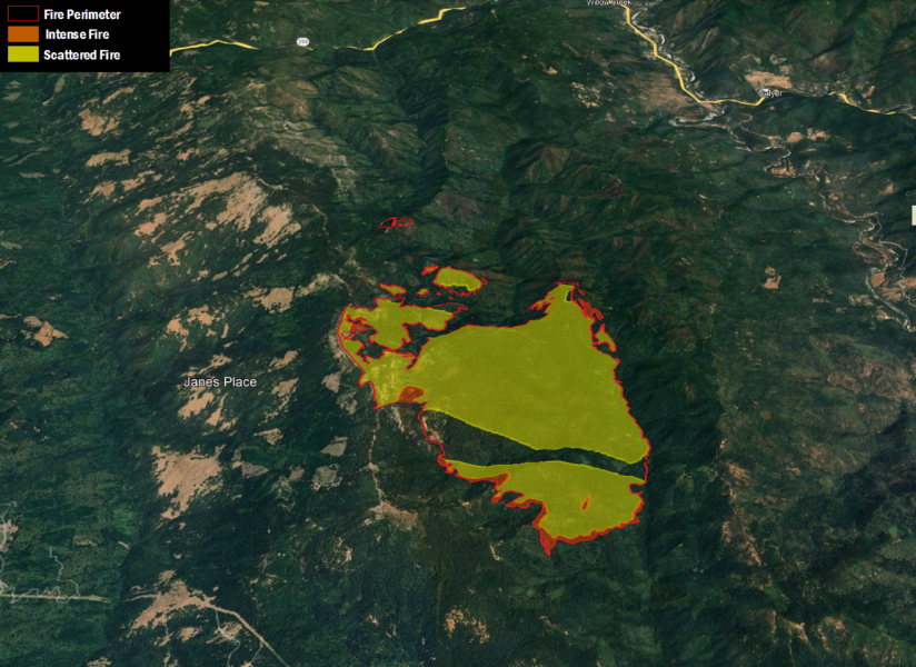
Here is the new map:

Earlier:
- Lightning Activity Starts Fires in the Shasta-Trinity National Forest
- At Least 50 Lightning Strikes in the Six Rivers National Forest Cause Multiple Fires
- Evacuations as the Hill Fire South of Willow Creek Grows
- Hill Fire in Humboldt County Jumps to 3,437 Acres, 0% Containment
- Extreme Fire Behavior Possible on the Hill Fire Today Due to Weather Conditions
- Hill Fire Grows to about 4600 Acres, Still 0% Containment
- Pyrocumulus Cloud Forming Over the Hill Fire Early Today


Join the discussion! For rules visit: https://kymkemp.com/commenting-rules
Comments system how-to: https://wpdiscuz.com/community/postid/10599/
Terrain is very steep in there. Lots of Cal Fire trucks headed up the hill to Willow and their crews all over.
Prayers for are firefighters
I find the fire evacuation zones very difficult to understand. Is there anywhere a map that shows these zones overlaid with a topo map or any map showing landmarks that can be used to figure out their boundaries?! I don’t know anybody in the hills who knows their “fire zone” nor do I know mine…Such an important thing deserves better maps…
Didnt they have 3 fires that merged into one a few years ago? If so the fuel loads shouldn’t be as bad as it was. At least if it burns up to the other fire it should be quite as hot.