
[UPDATE 7 p.m.] Hopkins Fire in the August Complex Burning in Trinity County and Moving Towards Humboldt
!["Leaving Kettenpom tonight." [Photo from Christine Eichin was posted on Facebook at 12:30 a.m., used with her permission]](https://kymkemp.com/wp-content/uploads/2020/09/119081447_10220096199649092_6483960012591175088_o.jpg)
“Leaving Kettenpom tonight.” [Photo from Christine Eichin was posted on Facebook at 12:30 a.m., used with her permission]
NOTE: The information on this page is out of date. Click the following link for more information.
——————————————————————————-
The Hopkins Fire which is part of the August Complex and burning in southern Trinity County is now 49,887 acres and 0% contained. Heavy smoke yesterday dampened down visibility and kept aircraft from flying but today, there should be less smoke.
We will be updating here as we know more. We will also update each section with information.
UPDATE 11 a.m.: Emergency personnel are doing a “hard closure” at Hwy 36 and Alderpoint Road and for Sawmill Road and Alderpoint. (That means a complete closure but those evacuating can leave though they can not come back.)
UPDATE 1:20 p.m.: New Evacuation Order for Areas South of Hwy 36, Along Alderpoint Road, and Down to Mendocino County Line
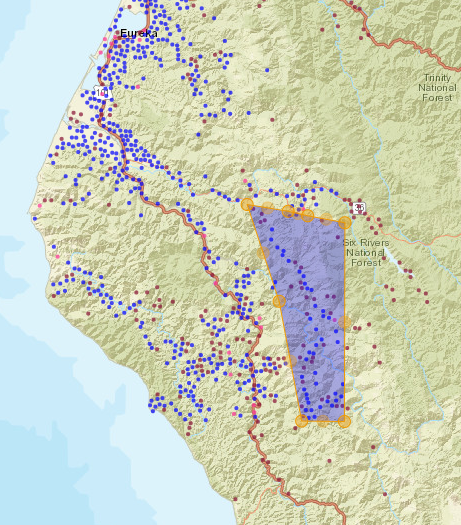
Evacuation map from the HCSO.
UPDATE 2:12 p.m.: Click here for the Afternoon Map for Hopkins Fire. There is also more information about the fire.
UPDATE 2:35 p.m.: There is an Evacuation Warning for Garberville and Areas West of Bell Springs Road to Hwy 101
UPDATE 4:03 p.m.: The video below and this link, Evacuation Order and Warning Information for SoHum in One Place, have the latest information:
UPDATE 7 p.m.: Evacuation Warning Area Expanded for SoHum
The Roads:
Here is the latest information: Information on Highways Closed Due to Fires
The Weather:
Please remember there is extreme fire danger throughout northern California today due to strong winds and low humidity. “These conditions may allow new or existing fires to spread rapidly,” according to the National Weather Service.
There is a Red Flag warning until 5 p.m. over the fire area.
Winds will be blowing from the northeast in the morning and getting up to 10-15 mph. In the afternoon, there could be gusts up to 30 mph. The temperatures will range from in the eighties to nineties.
Compelling Imagery:
https://www.facebook.com/jessicabentonstokesberry/posts/10158603409498584
The Maps:
- Map –to see details either zoom or click on the map and download a pdf.
Afternoon map [Zoom or click to download a pdf]
Evacuation information:
- Evacuation Warnings Sent to Southeastern Humboldt–Island Mountain, Palo Verde, Alderpoint, and Harris–as August Complex Spreads West
- Most recent for Trinity County: The following areas: Zenia, Kettenpom, Hettenshaw Valley, and all areas south of Ruth.
- Most recent as of Noon for Mendocino County: Evacuation Updates for Covelo Area
- Most recent as of 1:30 p.m. for Humboldt County: Evacuation Order for Areas South of Hwy 36, Along Alderpoint Road, and Down to Mendocino County Line
- Evacuation Warning for Garberville and Areas West of Bell Springs Road to Hwy 101
- Evacuation Order and Warning Information for SoHum in One Place
- As of 6:05 p.m.: Evacuation Warning Area Expanded for SoHum [MAP]
USEFUL Information:
- Evacuations for animals Humboldt: “If you have a need to evacuate animals please contact the Humboldt County Fairgrounds to arrange for drop off. HCF is also arranging for trailers if needed to transport animals. Please call 707-496-8841.
- Evacuations for animals Mendocino:The Laytonville rodeo grounds are open for livestock. They are located at Harwood Road Laytonville, call ahead at 707-984-8100 Harwood Hall is also open for residents feeling the Hopkins fire. They are located 44400 Willis Ave, Laytonville
- Evacuation place for Trinity residents: The temporary evacuation point remains at Southern Trinity High School located at 600 Van Duzen Road.
- Evacuation place for Humboldt residents:
- The Mateel Community Center located at 59 Rusk Lane will be open as an evacuation shelter this Wednesday afternoon and as needed. “Small pets are welcome with leashes outside the hall, no pets are allowed inside the hall due to potential allergy reactions for some individuals. For more information about the ongoing fire evacuation center located at the Mateel visit mateel.org. “
- As of noon Wednesday, the Humboldt County Fairgrounds has been designated as an Office of Emergency Services County-wide Evacuation Center for both human and livestock fire evacuees. Because of COVID, human evacuees need to have trailers and RV’s and/or tent campers.
- Redwood Acres is preparing to take in fire evacuees, both livestock and those who have an RV or are willing to camp. There is a chance that the Red Cross may want to set up a station.
- Evacuation place for Mendocino Residents-
- 1. Covelo High School for people (76280 High School Street) 2. Covelo Rodeo Grounds for small/large animals/livestock (77286 Covelo Road)
- The Laytonville rodeo grounds are open for livestock. They are located at Harwood Road Laytonville, call ahead at 707-984-8100 Harwood Hall is also open for residents feeling the Hopkins fire. They are located 44400 Willis Ave, Laytonville
- You can listen to Trinity County Scanner by clicking here Trinity County Public Safety
- You can listen to Southern Humboldt County Scanner by clicking here Humboldt County Law, Fire and EMS – Eureka and South
- You can listen to Mendocino County Scanner by clicking here Mendocino County Sheriff, Fire, EMS, Cal Fire and CHP
- Good fire and smoke info here: Click here. (Please remember the info here isn’t always up to date. If you are given an evacuation order, leave–no matter what this says.)
- Good Social Media Site–FIRE EVACUEE INFO – Humboldt/Northern Mendo/Trinity Fires: Click here
- Water Station Open for Fire Evacuees at Rio Dell City Hall
Earlier Chapters:
- Evacuation Warnings Sent to Southeastern Humboldt–Island Mountain, Palo Verde, Alderpoint, and Harris–as August Complex Spreads West
- Fire Forcing Evacuations in Three Forks, South of Ruth Lake
Join the discussion! For rules visit: https://kymkemp.com/commenting-rules
Comments system how-to: https://wpdiscuz.com/community/postid/10599/
We have a cabin for a family with pets on South Fork Mtn, no fencing but open space. Need 4wd to get in and out
Is it too much to ask for some support from our military and president and governor . We can fight a war but cant fight a fire i guess . Feels like were under attack right about now.
Federal Aid has been released. It’s up to Newsom to put it to use.
Newsom, yesterday stated that “90% of the California wildfires are human caused.”
Combine that with 100% of the urban fires are human caused.
Are we experiencing the end of times? or just a cultural revolution?
Newsome is wrong! Forest have been mismanaged for decades. California has done no prescribed burns for decades. He always blames someone or something else besides the gov in california. He never takes responsibility.
There are 33 million acres of forest(ed) lands in California.
Federal ownership is 19 million acres = 57%
State and local agencies (including land trusts) own 3%
Privately owned forest lands are 13.3 million acres = 40%
Who are you going to blame now W?
It’s not necessarily the governors fault, it’s the Democrat(see environmentalist) agenda to ban or make it cost prohibitive to log in California, especially on public lands like National forests. The USFS doesn’t do hardly any logging in CA due to all kinds of trumped up environmental reasons and wack job organizations like EPIC suing the USFS everytime they try to do any substantial thinning projects or timber sales. Logging helps thin the forests or clearcuts help create large fire breaks.
Prescribed burns do happen sparingly but definatley not on USFS land in any meaningful scale or scope. Rarely does Calfire or any other state/federal agency do any burns as well due to the liability issues. Not to mention all the fire fighters that could do prescribed burns are too busy putting out fire or are worked raw by the time of the year to do prescribed burns. There are also other factors prohibiting burning such wack job state agencies such as the air quality board which you need a permit from and have to pay substantial fees to when doing any large scale burns. All this enacted regulation and prohibition, combined with dismal federal funding of the USFS (thanks to no income generated by no timber sales because the USFS isnt allowed to sell harvest plans to the highest bidder on national forest lands) has resulted in severe hamstrings in the ability to manage our forests.
While logging and thinning CAN be the same thing, most times they are not.
There are also most often two different mindsets between how the two are approached. Not always, but generally speaking
Your’re wrong! Cal Fire absolutely does controlled burns.
“CAL FIRE uses numerous methods to help reduce the likelihood of severe damage caused by large, devastating wildfires on our lands and in our communities. One of these methods is prescribed fire.”
https://www.readyforwildfire.org/more/prescribed-fires/
Thank you for facts ghostown.
All that site states is information regarding prescribed fires with no dates or areas burned. The state has not done enough Prescribed fires to make an impact.
That may be true, but I am specifically responding to the comment that Cal Fire has “done no prescribed burns for decades.” That statement is patently FALSE.
I agree
Ya they did a prescribed burn over by ruth lake a couple days ago and it made things way worse.
You sure about that?!”couple days ago”?
Since two lightning series ago this Summer, the States been stretched thin. The burn window might be later after some rain! Besides Calfire, Forest Service, and BLM, theres also Native American, Ranchers, and homesteaders burning. Check out the Humboldt Perscribed Burn Association and the Klamath Watershed Alliance “TREX” burning. Actually Humboldt leads the State in using prescribed fire Homie!
Local farmer: No ‘they’ didn’t. First of all you are confusing a backfire with a prescribed burn. Prescribed burns are only done in fall or winter, not summer. And no one did a backfire on the Hopkins fire, 35 mph winds came up. Lightning started this fire and wind made it worse. So learn what you are talking about before you post.
Drop in the bucket compared to Oregon. Oregon uses private contract crews which cdf won’t allow. Cdf is a big racket.
There are prescribed burns every winter and fall! What are you talking about? The USFS burns all they can under the reduced Fuels budget that the Trump administration has left them with…they cut it by 40% 2 years in a row now..
Since you seem ignorant as to the fact we are in the middle of a climate crisis now…..I have talking about climate change for 40 years but so many don’t take the time to educate themselves and our government with both GWB and Trump did absolutely nothing to help stop the increasing possibility of what we are now experiencing….educate yourself and unite with those of us who are Activists saving our planet for posterity.
Climate change is a hoax. Trump 2020
Democrats are ruining our country. Just like Russia and Ukraine what is next
Anyone with common sense knows the forest are mismanaged by our democratic governor. Definitely not climate change!!! Our streets are filled with drug addicts and no one goes to jail. Do not have this problems in Republican states
?yawn! This thread is about our local fires. The kool aid party is at fox and cnn’s comment section. You took a wrong turn back when you thought anybody gives a shit about political drama.
Not the governor, decades of bad Democrat policy is to blame. Newsome is bad because he can’t ever recognize this.
Climate change is real, but let’s evaluate it. The earth is warming up naturally after an ice age. Now you can argue that humans are accelerating it, and for this point we’ll accept that. Even if we are, the earth is going to continue warming even if we negate all human impact… best case is we slow it down. Over millions of years the average temperature of the earth has been up to 20 degrees warmer than it is now.
So climate change is coming whether we impact it or not, yet politicians give the illusion that we can stop it and remain in the sweet spot we’ve been in while coming out of the ice age (ideal conditions for human life). But we can’t.
So logic would dictate we take steps to mitigate the consequences of inevitable global warming. One of these steps would be managing forests better to prevent the spread of wildfires. We need action instead of just pointing fingers… even if someone else causes a car accident you’re in, you’d still want to be wearing a seatbelt, wouldn’t you?
Another whack job left winger blaming Trump for forest practices that far predate his administration and as if any organization can put out a fire in this rugged country, which has occasionally burned from time immemorial. Look at the lone pines and dying oaks in the middle of those fir forests in that country. Those firs grew up after large fires then oaks and pines came back to then be replaced by fir. The older firs all have burn scars on them. This is simply nature in action. It doesn’t help that many are man caused now and there are less animals to graze the brush, but the west is burn country, pure and simple.
I can donate some feed for anyone taking it over from the coast.
Bad ass! Step up everyone, what is going on out here is horrible!
Thank you Kym for keeping us updated! Please let us know when any updates are available. God bless.
fires moving like an amoeba .
Anyone know how it looks at lone pine ranch? Just heavy smoke or active fires?
Judging by the map- lone pine looks safe as of now.
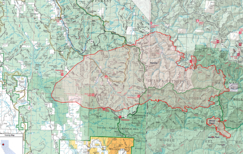
Not sure about Lone Pine but the Travis Ranch is on fire and it’s moved further west across the North Fork Eel, Salt Creek, and into the Kettenpom Valley/Kettenpom/Haoglin area. Last I could see it was working its way down to the main stem Eel across from Palo Verde.
Lake mountain ?
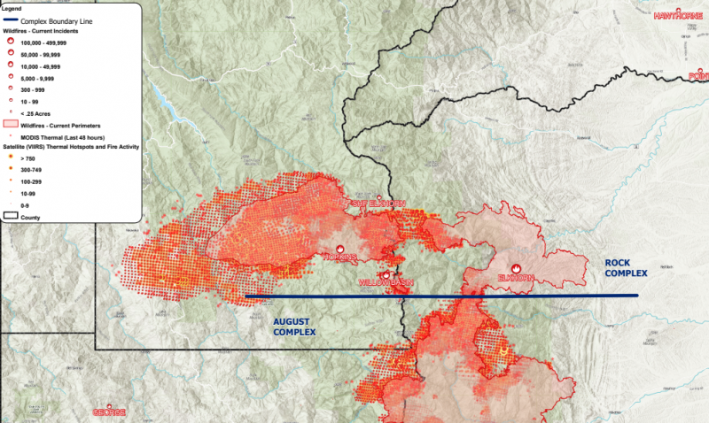
Looks like the fire perimeter was just updated and it has reached Lake Mountain. See the screengrab below. Still awaiting the satellites to make another pass to update the heat signatures in that area.
Large, fully fenced yard available. Also have a small travel trailer for staying in.
Hydesville
Anyone know the status on Blocksburg and headed to Bridgeville?
You can head out but they just started setting up road blocks to keep people from going to their prop. Just drove from alderpoint to blockberg to bridgeville. Some cops around while farmers pack what they can fit and are leaving.
There evacuating atm
Northern Mendocino County area in evacuation and warning areas.
Feeling so helpless… off trying to save other people’s home on a fire and in about to lose mine at home.
Love and prayers to you.
We are experiencing the effects from climate crisis that has been exasperating going on 40 years now….Please know you are doing what anyone would do in these times…You are such a great neighbor!! Hopefully your home will be spared….If not be happy you are alive as well as your family and friends and animals.
Kym, does any one have a complete roster of local VFDs & phone numbers?
Anyone??
https://humboldtgov.org/Archive.aspx?AMID=75
So covelo just has been evacuated so taking your animals to laytonville fairgrounds may not be an option. It might be a good idea to call down before bringing them there.
For those heading to Laytonville,
I just got home from Laytonville about 2 hrs. ago.
Traffic good
Bank closed
Chevron station busy with cars backed up 3 and 4 deep
Grocery store open but staples are running thin or gone, no bread, few chips and snacks, soda thin, water gone, meats good stock. hot dogs cheese and dairy running thin.
phone cards sold out but chevron may have some I didn’t check.
next deliveries unknown.
So if I live up AP but am not under evacuation yet, if I leave to go to the store, will I be able to get back home?
I am taking a load of garden vegetables to the evac center on Van Duzen rd if anyone wants some. Been a fire refugee living out of a truck on MRE’s, it sucks. Come get a fresh tomato! Keep your health up! About 3pm.
chuck , thank you for being the needed helpful hand here today , way to be the change man, truly great full from the bottom of my heart for seeing you offering a helping hand , times like these are not the time to bicker but to set aside differences and help each other.
Is this fire really moving NW toward Bridgeville from the south. Is there a link for the latest fire map that shows direction it is heading. Would Buck Mountain be in a current evacuation area or just be prepared?
Be prepared. We are currently waiting for the next flyover by the satellites to see where it has spread to. See below for the last update from 12am last night.
For those listening to Broadcastify
https://www.broadcastify.com/listen/ctid/194
here are codes for scanner speak.
https://copradar.com/tencodes/tencodeg.pdf
Kym please verify the fairgrounds mentioned as an Evacuation Center in the above information.
I live in Ferndale and the Red Cross is setting up for evacuees here.
https://www.times-standard.com/2020/09/09/shelters-in-humboldt-county-activated-southern-humboldt-residents-evacuate-for-wildfire/
Any news about fire after 7 pm last night?
any update on fire around blocksburg
All I know is that hot shots have been defunded here, we do have prescribed burns regularly, but the hills are tinder dry, snapping your fingers could start a fire , and our fire staff is severely understaffed and underpaid. Most of our current Sequoia/ Yosemite fires have been started by lightning! Gov’nor!
Fire is natures way of clearing the dead to rejuvenate the earth. Nature didn’t factor in how many people on this planet wanted to build in these areas. Where it is unsafe for firefighters to access the terrain that is currently on fire. Someone needs to light on fire under Trump. Climate is changing on the planet and people are helping to accelerate it.