
Evacuation Warning Area Expanded for SoHum
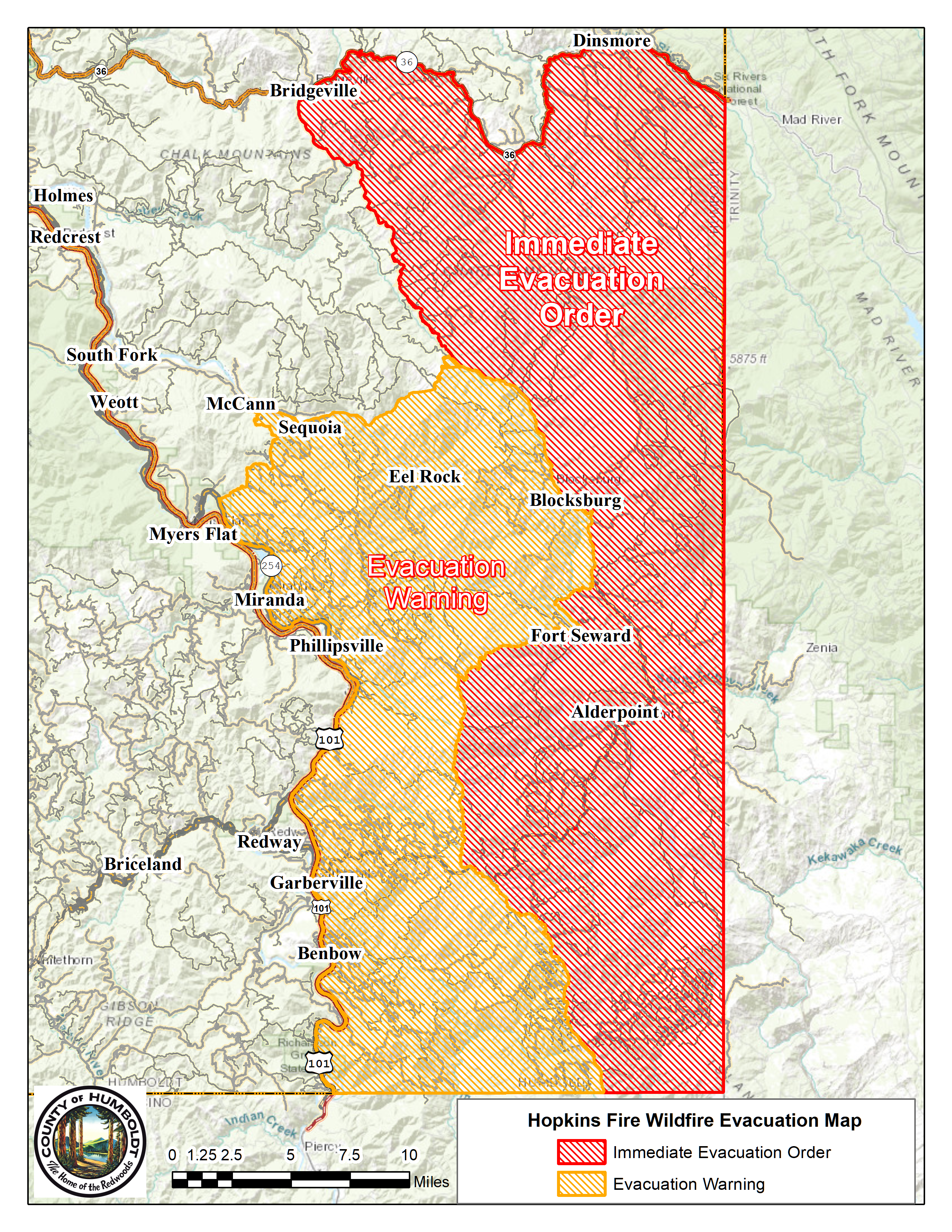
Evacuation order and warning map for Southern Humboldt as of 5:45 p.m.
Press release from the Humboldt County Sheriff’s Office:
EXPANDED EVACUATION WARNING AREA.
The Hopkins Fire Evacuation Warning area for Humboldt County has been expanded to include all areas west of Bell Springs Road to Highway 101 spanning from Elk Creek Road / Dyerville Loop Road to the Mendocino / Trinity County Line.
Join the discussion! For rules visit: https://kymkemp.com/commenting-rules
Comments system how-to: https://wpdiscuz.com/community/postid/10599/
This is crazy. Please share any useful, reliable information you have. Any know what if AP is still ok?
So far so good!
Thanks Pharm!
Yikes!!
Is Windy Gap( Wade rd) in the mandatory evac area??
Not by a few miles +/-2….
Read on Facebook that winds have shifted the fire away from Garberville… not sure… it can easily shift again. Stay safe!
Can you please share the Facebook page where you read that info. Thank you
Any info about the Lone Pine Ranch?
This is a helpful link:
https://data.delmarvanow.com/fires/incident/photograph/6983/0/104973/
Not super helpful as the last info was from 9/6/20. I like and need useful fire map info but if it is not current it is bad intel. Am I missing a way to update?
That looks like a good place to get information. Scroll down through the fires and click on the blue. The map looks small but it is super fast zoom in and out and you can fallow the hot spots to get a good idea of the fires border. First place I have seen that they are calling the Hopkins fire the Elkhorn fire because they have merged. The only information that must not be right is it says there are only 345 fire fighters fighting the fire. It also time stamps the information you are looking at.
Yes there is a link to go back to the August Complex details page. It is updated frequently and all the info is from the 6am hour this morning. Here is that direct link. https://data.delmarvanow.com/fires/incident/6983/august-complex/
anyone know whats going on on South Fork Mountain Road?
nothing really happening on south fork mtn rd but lots of smoke and got pretty dark yday afternoon
What about burr valley road
I just got back from Palo Verde an hour ago. I ran into the volunteer fire figthers out there around 8-830. They we on standby along the road before Heartwood and confirmed that the fire HAS NOT crossed the Eel. At least not below Walker Ridge/Palo Verde/Island Mountain. At least for now. The winds have also shifted and died down. They are now blowing to the south/south east lighly. Fingers crossed it has stopped its westward advance.
This is welcome news. Thanks for sharing.
Thank you!! So many people saying it jumped eel which between wind direction and that being most important. I also heard they pulled some crews off oak fire to help. Prayers and positivity palo, bell springs and Alderpoint and everyone in state of stressful ness
May I suggest listening to KMUD news, Sheriff Honsal began last night’s 6pm program (repeated at 8am today) by saying those Palo Verde volunteer fire fighters had investigated the rumors of the fire jumping the Eel in their area, and could find no evidence of that (as of last nite). We are so blessed to have Kym here doing her usual amazing hardwork at a time of crisis, KMUD news, and facebook… but one needs to check them all it seems. Thanks to those folks, all the hardworking fire fighters!, and the many helpful commenters. Sympathy to all those evacuating!
There is an area where it has made it into the Eel River canyon and it did make it across at one point but CalFire managed to regain ground it. The area this occured was in Eastern Mendocino County bordering National Forest near Black Butte River south east of Covelo. Hope this clears confusion.
Is Bell Springs Rd safe? My son not answering and heard road was closed
Is Dinsmore evacuating ?
Humbolt County updates? I.am in Texas my son there…last I heard from him was 2 days ago
?
Here’s the latest: https://kymkemp.com/2020/09/10/elkhorn-fire-new-name-for-fire-causing-evacuations-in-trinity-humboldt-and-mendocino-slowed-with-cooler-weather/