
[UPDATE 4:50 p.m.: Controlled Traffic ] Hwy 299 Is Closed After Head-on Crash Leads to Wildfire

Smoke rising from the Kennedy Fire. [Photo from AlertWildfire]

At 12:42 p.m, the 15 acre Kennedy Fire is close to the lake.
Please remember that this story is unfolding. Information is being reported as we gather it. However, some of the information coming from witnesses and initial official reports could be wrong. We will do our best to get the facts but, in the case that something is inaccurate, we will update with correct information as soon as we can.
UPDATE 12:51 p.m.: Caltrans reports, “Eastbound and Westbound State Route 299 is closed at Rock Creek Rd approx 7 miles west of Redding (Shasta County) due to a accident. A detour is available. Motorists should expect a delay and to use an alternate route.”
UPDATE 12:56 p.m.: In this closer view of the crash scene taken just after 12 noon, black smoke pours from the engulfed big rig.
UPDATE 1 p.m.: The CHP Traffic Incident Information Page is now reporting this is a fatal crash.![In this closer view of the crash scene, black smoke pours from engulfed big rig. [Image from AlertWildfire]](https://kymkemp.com/wp-content/uploads/2022/08/Close-up-Kennedy-fire.png)
UPDATE 1:05 p.m.: This image shows the location of the fire to the lake.

The orange cone shows the view of the camera taking the photo with the caption that it was taken at 12:42 p.m.[Image from AlertWildfire]

The scene of the crash is just a smoking ruin now. But the wildfire continues to grow. [Photo from Cal Fire’s Shasta Unit]
UPDATE 1:25 p.m.: AlertWildfire Cam caught this plane dropping retardant just minutes ago.
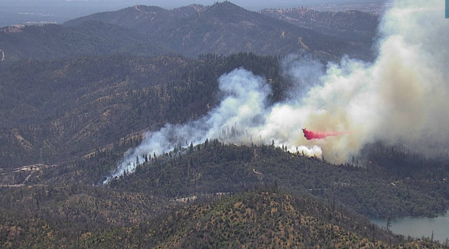
At 1:23 p.m., AlertWildfire Cam caught this plane dropping retardant.
UPDATE 2 p.m.: The Redding News team interviewed a CHP officer here: https://twitter.com/BreakingNews_RS/status/1560367571320205312 He says the driver of the SUV which drifted over the line is dead. And the driver of the big rig was out of his vehicle and active.
UPDATE 2:33 p.m.: Firis gives a great overview of the fire and states that the latest acreage is 34 acres.
OES Intel 12, Aug 18th on the #KennedyFire, SHF/Whiskey National Park. Fire is mapped at 34 acres. pic.twitter.com/fDVN17Mnnp
— FIRIS (@FIRIS) August 18, 2022
In potential good news, the fire is slowing down and a few resources have been released. However, there is no official word yet that forward spread has been stopped.
UPDATE 5 p.m.: Caltrans has not released official word but the CHP Traffic Incident Information Page reports that traffic is moving slowly in both directions. And, Caltrans QuickMap states, “State Route 299 is reduced to one lane with traffic control from Old Shasta, 6 miles west of Redding, to the Whiskeytown Visitor’s Center, 8 miles west of Redding, due to a vehicle collision and vegetation fire. No detour available. Motorists should expect delays.”
Join the discussion! For rules visit: https://kymkemp.com/commenting-rules
Comments system how-to: https://wpdiscuz.com/community/postid/10599/
Passing lane accident likely.
That’s right above the Hells Angel’s Redding Chapter, which is pictured near the black billowing smoke.
Scratch that.
If you bothered to look at the pictures you would have noted that is not a passing lane area
I thought that part burned in the last fire?
The one caused by a flat tire on a camper.
We have to remember the last fire that was started around whiskey town Almost Took the city of Redding it did take the outskirts there shouldn’t be a lot to burn there Please take care of everyone and put it out soon
Unfortunately there’s lots still unburned there. Ready to burn again
My sincere condolences to the family and friends of the person that died in that crash. May they RIP. God bless.
And stay in their own lane in heaven