
Fire, Flood, and Fire Again: The McKinney Fire Grows in the Aftermath of Torrential Rains

A Conex box rests next to a bridge on Humbug Creek Road after heavy rains on the evening of August 2 caused localized flooding and debris flows. [Image from InciWeb]
Nearby fires are expanding also, including the Yeti Fire (formerly named the China2 Fire) and the Alex Fire Complex which have grown to 4,626 acres with 0% containment. Another a new fire, this one known as the Smokey Fire, is already 40 acres this morning.
Firefighters are also contending with the aftermath of hard rains which sent large debris flows sprawling over roads and sometimes into equipment. One contractor was taken to the hospital after his pickup was swept away after a bridge gave out.
According to the Klamath National Forest Public Affairs Office,
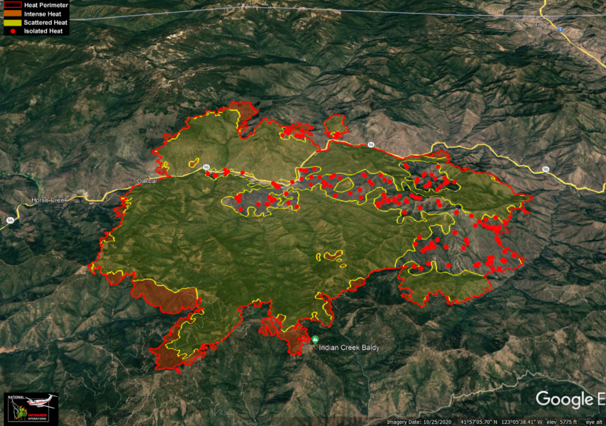
Tuesday’s thunderstorms dropped 1-3 inches of rain on the eastern flank of the McKinney Fire. The higher amounts fell on the eastern one third. Heavy debris flow occurred as a result in multiple drainages and blocked lower lying portions of Humbug Creek Rd. On Wednesday morning, heavy equipment was used to reestablish access into the area for the firefighters working that branch of the fire. Although a considerable amount of rain fell, many pockets of heat remain. As the area dries in the coming days, fire activity in the east is expected to pick up once again. The western half of the fire did not receive measurable precipitation.
Yesterday morning fire behavior was minimal over the entire incident with very little active burning. Pockets of heavy fuels continued to smoke throughout the morning and fire activity picked up on the western portion of the incident as fuels, heated by the afternoon sun, began to dry out. The fire was most active near Mill Creek Road in the southwest portion and Pipeline Gap in the northwest. Pipeline Gap is an area with high potential for fire spread. Helicopters and air tankers were used to support firefighters on the ground as they fought to limit spread in both areas. Aircraft dropped over 50,000 gallons of retardant during the operational period.
Progress in fireline construction has been steady but slow going along the fire’s edge. Difficult terrain and heavy fuels have been a challenge. However, dozer lines have been completed in multiple areas surrounding the fire. The fire is holding along the river’s edge east of Horse Creek along Highway 96.
An increase in fire behavior due to weather changing over the next several days will add to the challenge. Firefighters will keep a close eye on conditions today as they continue direct line construction wherever it is safe to do so. They will also evaluate options near Pipeline Gap, Bald Mountain and Baldy Gap where direct line construction may not be an option.
We’ve gathered the most important information about the McKinney Fire and organized it below for our readers.
Stats:

Compelling Images:
Here’s some exclusive video, that I just received from a source who wished to be “unnamed”, of what firefighters near the #McKinneyFire were having to deal with yesterday with all the debris flows from rain ??. #weather #Rain pic.twitter.com/0TGYVUsjER
— Brett Austin Taylor (@Brett_Taylor94) August 4, 2022
A Lookout reader sent some videos of the aftermath of debris flow/flash flood on Div W of #McKinneyFire yesterday, 8/2/2022. 1/3 pic.twitter.com/vYOsZciTbe
— Zeke Lunder ~ The Lookout (@wildland_zko) August 4, 2022

One pickup after torrential rains. “Tuesday night we had a bridge give out near Humbug Rd within the evacuation zone. The individual inside was a private contractor working the fire & was taken to the hospital with non-life threatening injuries.” [Photo and caption from the Siskiyou County Sheriff’s Office]

The mudflows impact after the torrential rains. [Photo from the Siskiyou County Sheriff’s Office]

Smoke Rising from the Yeti Fire. [Photo from the Siskiyou County Sheriff’s Office]

Flames moving toward homes in Siskiyou County. [Photo from the Siskiyou County Sheriff’s Office]
The Plan:
The Weather:
According to the Klamath National Forest Public Affairs Office, “The fire area will be warmer and drier today. Humidity on peak and ridges started out lower today and winds will primarily out of the west this afternoon.”
The Roads:

Siskiyou County Sheriff’s Office posted this image of the closure on Hwy 96.
According to InciWeb, “A portion of Highway 96 [from Route 263 to Scott River Road] is closed due to the fire. Prior to traveling, please check CalTrans Road Conditions at https://roads.dot.ca.gov/ for the most current road conditions.”
The Maps:
- Operations Map –to see details either zoom or click on the map and download a pdf.
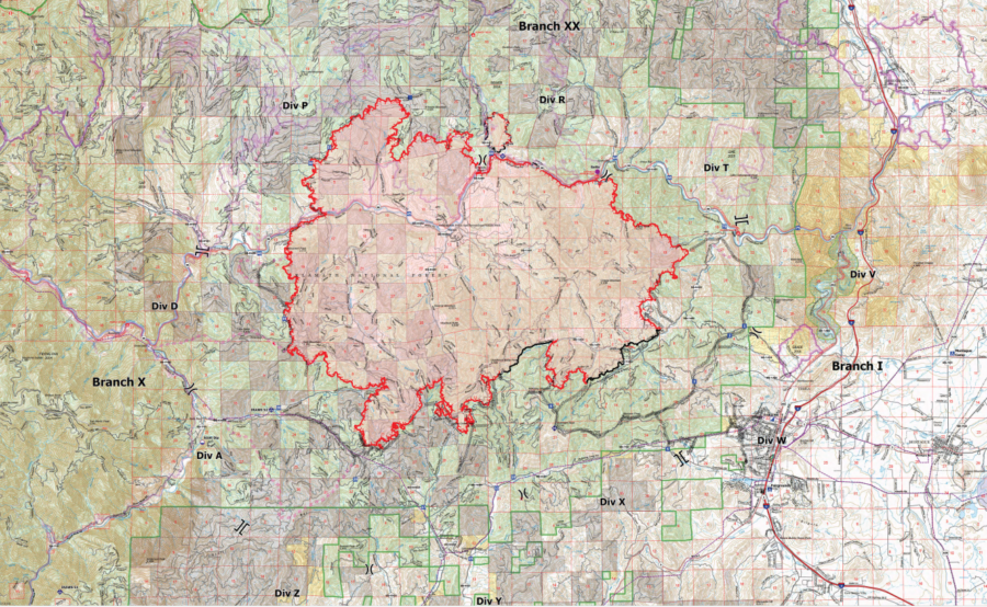
- KMZ Map–Zoom for detail or for 3D imagery, click on the map and download a file that connects with your Google Earth program.
Evacuation and Help Information Including Community Meetings:
Multiple Evacuation orders and warnings remain in effect. For current updates on evacuations, visit the Facebook pages of the Siskiyou County Sheriff’s Office and Siskiyou County Office of Emergency Services. Additional evacuation information and map can be found on the Zonehaven website. A shelter has been established at the Weed Community Center, 161 E Lincoln Ave., Weed, CA 96094.
Earlier:
- McKinney Fire West of Yreka Swallows Over 78 Square Miles, 400 Structures Threatened
- McKinney Fire Burns Multiple Homes and Vehicles [Photos of the Destruction Left Behind]
- Two Found Dead Fleeing the McKinney Fire; This Morning 0% Containment and Over 55,000 Acres
- Firefighters Dig In as Rain Held the McKinney Fire to Slow Growth
- Deadly McKinney Fire Still 0% Contained Even After Rain
Join the discussion! For rules visit: https://kymkemp.com/commenting-rules
Comments system how-to: https://wpdiscuz.com/community/postid/10599/
So what I’m hearing is that the rain was just a giant headache and made everything about the fire just that much worse….????
Cuz what I was feeling was “thank You God for the rain” that was a direct answer to the prayers of many, no doubt!
I’m thinking it helped the firefighters be able to get that 10% containment AND slow down fire activity.
So please let me be the first to publicly thank God on this forum! I’m grateful. And I’m hoping I’m not the only one…
I am thankful that the rain came and tempered that fire…
I was praying for rain for them as well…
Did we overdo it? LOL?
Or was that much rain what it took to tame that monster?
There were flash flood warnings for yesterday, but I think they were for the other side of I-5.
https://www.actionnewsnow.com/news/local/siskiyou-county-sheriffs-office-issues-evacuation-warning-due-to-flooding/article_6ba80f82-12d1-11ed-8521-570d92236bff.html
Mt Shasta Vista, and Juniper Valley…
? Attitude of Gratitude ?♥️♥️♥️♥️♥️♥️♥️♥️♥️♥️
♥️♥️♥️♥️♥️♥️♥️♥️♥️♥️
? Attitude of Gratitude ?♥️♥️♥️♥️♥️♥️♥️♥️♥️♥️
If you’re reading this, you have something to be grateful for!
The rains were not torrential. A few localized thunderstorms.
they were microbursts which are intense and cause torrential rains and high winds within the area they impact. these fires can change weather and create weather. NOAAs ocean forecasts during these fires are never accurate due to the fact that their modeling software doesn’t include the changes made by the intense thermal gradients. the above images themselves can confirm torrential rain occurred within the watershed.
Damn we are so lucky to have such stellar local reporting.
Am continually blown away!!
Thank you so much Kym and team ❤
And of course thanks to the firefighters, sawyers, water tenders etc for braving extreme multi elemental dangers.
I hope one or more of the big truck companies sees that video and gives those private contractors some new trucks!!!
Something tells me that video will spread.
We just had a public Broadcast message on TV that said to evacuate eastern Yreka ?
Now they changed it to Happy Camp that’s under mandatory evacuation orders
“I’ve seen fire and I’ve seen rain I’ve seen sunny days that I thought would never end”
J. T.