
[UPDATED With more video posted at 2:05 p.m.] Saturated! Storm Photos and Videos
Mad River [Video shared by KMUD]
The clouds opened up their water spigots over the North Coast and the Mad River and numerous creeks overflowed their banks. The downpour caused serious problems on roads and in residences across the Emerald Triangle but particularly in Humboldt County around the Blue Lake area.
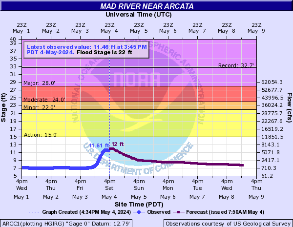
The Humboldt County Office of Emergency Servicess said, “This is the most significant flooding of the Mad River since 1964.
About 9 p.m., the Mad River reached over 27 feet causing widespread flooding in Blue Lake. According to NOAA, when the river reaches 26 feet, expect “severe flooding along Mad River Beach Road and extensive flooding of farm lands and other roads in the area. Flooding of residential areas around Tyee City is likely. Any low-lying areas near the river could be flooded.” And they were right!
Reports from the scanner and social media in the Blue Lake area had everything from first responders rescuing people in stuck vehicles and a cat trapped under a house trying desperately to swim in the rising flood waters. [The cat survived!]
Hwy 101 at Hookton Road near College of the Redwoods south of Eureka flooded closing the northbound lanes completely. Southbound remained open. As of the time of publication [1:14 a.m.] northbound Hwy 101 is still closed.
There are unconfirmed social media accounts of travelers having to spend the night in the Loleta/Fortuna areas.
Blue Lake Casino had to close and postpone its show “due to flooding of roads and parking lots.”
Blue Lake Casino gas station and parking lot.
The serious flooding, particularly in the Blue Lake area of Humboldt County, with the Mad River’s overflow caused a number of challenges, particularly in terms of road closures and property damage. As folks get out to tell their stories, we might have more to share with our readers. But meanwhile, here are more photos and stories we’ve gleaned:
Other images:

Believe it or not, Thomas Road (about a half mile before the school) is somewhere under this mass of trees that fell not long before dark Saturday. Neighbors have since cleared the road. [Photo by Lisa Stone]

Off the Hammond Trail in McKinleyville. [Photo by Apryle Mercado]

North Fork lumber company in Korbel. [Photo by Jonny Beck]

A utility pole fell on a pickup loaded with a Canoe Kayak off Trinidad’s Scenic Drive. [Image from Tammy Hodapp]

Tree down across a road off Trinidad’s Scenic Drive. [Image from Tammy Hodapp]
https://www.facebook.com/humboldtbayfire/posts/pfbid0vESTwMiHRztqQWDKfkzB4gVAjhXsc3oqKbTbU1Fs1t4rh3s6EZNvPgbkq875vQnml
https://www.facebook.com/arcatafire/posts/pfbid034Q5mh76gLasSsUqFhEZVHpQmQYwg8UkCuhdbpP3iRmkccpf9BknuqAF1FzQdvEDyl
https://www.facebook.com/george.ponnay/posts/pfbid0iD2MM7yWs5SouTbfZ6TBncjLs4bVen7a75o9nbHqEtbnSSYJMYS4ZcGxaydsXT56l
UPDATE 8:45 a.m.: This video of the Freshwater Park was too astounding to not share.
UPDATE 2:05 p.m.: Here’s some video of taken this morning in Tyee City southwest of McKinleyville near the coast . “Mad River Rd turned into a river,” said Robert Schoenfield, local resident. “Lots of standing water and mud this morning.”
For our earlier storm coverage, click links below:
- Wet and Wild Out There: Pictures of Storm Impacts
- Multiple North Coast Rivers Flooding or High; Snow Impacting Highways Also
- Northbound 101 Closed Between Loleta and North Tompkins Hill Road
- State Route 211 Through Ferndale Closed Due to Flooding
Note: This piece was prepared with the help of many hands but a special thanks to Lauren Schmitt of KMUD News!
Join the discussion! For rules visit: https://kymkemp.com/commenting-rules
Comments system how-to: https://wpdiscuz.com/community/postid/10599/
That was a good rain! More on the way Tu-Wd and Fr-Mn. Not much time to dry out!
From my view in Eureka I thought “a good amount of rain, but not as much as they made it seem like it was gonna be.” Then I check the news after dark yesterday… I guess I was wrong lol. Look at all that water! Stay safe people!
And everyone survived!
Thank you for posting all the pictures. They really show the water and damage well. I feel sorry for the owner of the Chevrolet pickup with a Kayak on the roof and a utility pole smacked into the cab and all the other unlucky folks that got flooded.
That is a canoe, Martin.
Or, well, it WAS, a canoe.
It’s a taco now…
A foldaboat.
My fault. Said Kayak so I went with that. Yep, it is a fold-a-boat now!
That looks like a Coleman canoe: the prominent keel line, the aluminum gunnels. Made of Royalex (spelling?), plastic. Should pop right out. I have one. Nearly indestructible. Heavy though; my 17 footer is 80 lbs.
Eureka broke a 111-year rainfall record Saturday, Jan 13 with 2.45″.The previous record was 2.22″ in 1913.
Was it man-made climate change in 1913?
Dunno. I slept thru it.
So washed you don’t even understand the question, I’m sure …
Stupid questions deserve snappy answers.
Is it?
Seems there’s a whole lot of stock being put into our children’s future surrounding that question.
Cuts both ways, buddy, and the nuance is astounding.
Never forget: there’s far more the two of us agree on that not – but the narrative spinners want us divided so that we don’t come after them for ruining all our livelihoods. Don’t take the bait and fall into the trap.
“there’s far more the two of us agree”
Yes, far more than two of the us self-agree here and daily.
110 Years ago there was a lot more trees and fewer people.Now barren land-concrete-asphalt.Many years of effort keeping water off roads and property.The area once concerted a rain forest that’s long gone.
That makes sense.
Three inches in 24 hrs from Friday evening to Saturday evening at my SoHum spot.
Lots of ran. Back to the rainy fog cycle of weather as per usual on the southern tip of the PNW. Wonder how much it rained in Honeydew. Three years ago in Hanalei Kauai it rained 27 inches in 24 hours. Imagine that, I don’t think we can. Bring it on.
Wow!
Is this record specifically for jan13th or is it for any day?
24-hour period ending on Saturday, Jan 13. Yes, it’s for a specific day.
well if the rainy season is 150 days… we bound to set single day records every year
It always disappoints me that we even allow people to build houses and businesses within the 100-year floodplain. Somehow people seem to think that a hundred years is a long time, It isn’t.
There wasn’t a hundred years between the 1955 flood and the 1964 flood.
Astounding pictures and range of coverage. Once again RHBB demonstrates what a treasure it is. Thanks Kym, and thanks to Lauren and the many other contributors.
River got big mad
Wow! The mad got so Muddy the fish couldn’t handle it. I saw several salmon and steelhead walking east on 299, headed for the hatchery.
I bet they were Mad Salmon and Steelhead.
I wonder if some of this flooding is due to tree fall dams accumulating during the drought. Especially Freshwater Creek where I’ve seen twenty feet high ones piled in places. Usually the winter rains took out the debris each year but it hasn’t been rainy enough lately to move them.
Drove through the Hookton stretch of 101N last night following my wife in her CRV. The fire crew and CHP were already on scene. My wife seemed like she was going to stop or stall a few times. She feared cracking her manifold by splashing and getting it wet. I was mentally yelling, from behind, for her to keep moving as I was already viewing the entire situation through periscope of my tiny Civic hatchback. The Honda off the shoulder, tail first in the bushes, was none too reassuring despite the safety personnel presence.
Thank you, emergency responders, for your service.
The headline caught my eye. “1964”.
There’s a sign on highway 96, marking the flood mark
from 1964.
Near Willow Creek.
Made me wonder about this one.
Must be comparable.
We got the culvert clear of the boulders that washed down from 299 and clogged the drain that caused the flooding in my post Sunday morning. Thanks to all that came and helped with the clean up. Still sore from digging troughs and lifting sand bags, but we got it done! Thanks Blue Lake.