
[Update: Road Closed] Main Access to Petrolia and Honeydew Compromised
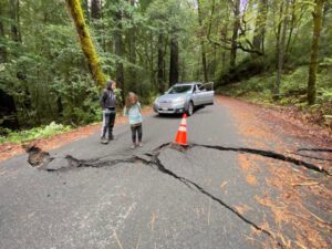
Damage to Bull Creek Flat Road [All photos by Mariah Gregori]
The road that runs west from the highway at the confluence of the south fork and main stem of the Eel River traverses through Humboldt Redwoods State Park, making the road maintenance a state park issue.
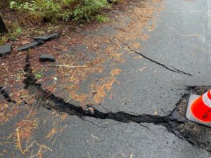 Just before 11 a.m. on January 17, a motorist took pictures of the damage to the roadway that is located just west of Highway 101 near wear Bull Creek meets the south fork of the Eel River.
The extent of the damage or stability of the roadway is unknown at this time. Please use caution in the area. Although it has been stated that the roadway will be closed at any time, we have been unable to confirm that information, in part to recent park closures due to the storms and the subsequent clean-up efforts.
We have reached out to California State Parks, Humboldt County Public Works, and Supervisor Michelle Bushnell. When we have additional information, we will provide an update.


Update 2:06 p.m.: Scanner traffic indicates that Bull Creek Flat Road is now closed. We were able to confirm the closure with a Humboldt County Public Works employee who confirmed that around 1:30 p.m. they were notified that the road was closed due to “extensive damage” to the roadway.
The road is closed 1.5 miles past Highway 254 (Avenue of the Giants) until 250 foot west of Mattole Road, according to the public works employee.
At this time there is no estimated time of reopening.
Update from State Parks: Mattole Road Closed Until Further Notice
Join the discussion! For rules visit: https://kymkemp.com/commenting-rules
Comments system how-to: https://wpdiscuz.com/community/postid/10599/
Discovered by the best Road Detectives!
Looks to activative as geometry of Crack relative to cone is diff in each Pic.
Looks easily passable if slowly
Until it slides into the river with you and your car along for the ride. That is how people die.
Nowhere near the river. Nice doomsaying though
That’s not sliding into the river
I would check both sides as a blown culvert could create a sinkhole like mendos creekside cabins. But yes it looks passable. Heard a growdozer pulling a trailer full of wood busted a leafspring.
Squirrel please keep in mind the large number of heavy equipment that travels that road daily from dump trucks to semi truck loaded with soil or hay or whatever. This is a very active road so even though slow is a good idea, it’s the number of vehicles that could cause further damage. We need this artery open and safe
Rex will have this fixed fast so there is no money lost on his grow out there.
And the other ones that his son “BearMace” Bohn “consulted” on ie. got the paperwork pushed through…
So true, he’s just a pawn to get permits pushed. Somehow they keep expanding but yet a fraction goes on the market.
and the putz award goes to
Explain
Must be a PG&E line around there somewhere !!!
Ya, but it’s buried through there.
Hell, just throw some asphalt in the cracks, good as new…
Yeah, that’s what they’ve been doing in the east bound lane just past the 4900 sign on AP Road for the last 10 years. I bet the road is 3 foot thick there by now.
That’s what they did on both ends of Fernbridge. They were separated, buckled, big gaps left wide open. Eh, throw some asphalt on it and call it good. Never mind the fact that huge chunks of cement are missing and fell off underneath exposing the rebar. Let everyone back on and let’s see how it goes! Ugh!!
So they should leave the cracks open so every vehicle pounds the Crack harder. Instead of smoothing it until it can be fixed. Be a shame for all if Ferndale had to go through redway to get to Fortuna. I know the alt routs, just sayin. Every bridge from south Scotia to north Fortuna has bigger bumps both sides after quakes.
It looks like only the repaved upper part is cracked in the photos. I don’t work for Caltrans, but I would slowly cross on the downhill side which is not as badly cracked. A quick peek, looks safe, motor on.
Have you seen what happens when rosds like this are driven on?
I remember when the bottom of huckleberry hill blew out, it of course started with a crack just like this one. A friend was the last to make it over the area, it looked ok but his back tires barely made it as the road completely crumbled under him&water chewed the road up in minutes.
Again it “looked ok”.
Unless youre a hydrologist or other person knowledgeable about these things, PLEASE stop saying ehhh just look at the side, if it looks good go for it.
You will make others think that this logic works in these situations, think it “looks ok” &drive over it and end up in a sinkhole.
Thats like driving thru an active slide area because “looks ok for now”.
If you personally want to drive over failing roads, you dont deserve the attention of first responders imho.
I have driven the back roads in Humboldt County for about 60 years and have encountered road conditions like this many times and after inspecting the damage have decided to drive over many. I have the freedom to say what I do and if you don’t like it that is fine with me. I just stated what I do. It was not a “go for it” for everyone. You will have to be your own judge!
Hello, sounds like you might be able to answer my question. I’m trying to get down to the Mattole campground these next few days, is it doable? Cheers
Are you referring to the Albee Campground Fish?
After the 1964 flood, it stopped raining the sun came out and we started trying to recover. It seems that what happened after the rain stopped the slides just kept coming. There was a theory that when the river went down it sucked the slides down with it. I don’t necessarily ascribe to that theory, but it seems that some of the major slides happen after the storm has subsided.
Two rules:
1) Soil is saturated.
2) Gravity never sleeps.
And saturated soil reduces friction.
The Ettersburg road down from the firehouse says “Hold my beer”
Looks just like before they took 2-3 years to fix it.
Having a major road that serves a significant local population that goes through a State Park and is under their control can be problematic as the residents of SoHum learned in 2011. Remember the Briceland Road washout through Whittemore Grove in 2011 when the county was trying to detour hundreds of cars per day onto the barely passable, unpaved in spots, Old Briceland road? RHBB covered it. State Parks gave us years of foot dragging excuses why the road that served so many couldn’t be permanently repaired: they needed engineering studies that would take at least a year, old growth trees were impacted by the massive log jam in Redwood Creek, ‘maybe we’ll have the funds next year’, anything but a concrete plan of action. Finally when a major culvert for a small creek under Briceland road near Whittemore Grove’s parking lot failed and had to be replaced on an emergency basis in 2019 the contractors snuck over to the 2011 slip out and quietly removed the concrete K rails and did the roadbed repair to get rid of the one lane bottleneck and the stop signs (which were a running joke–literally). Hint: only tourists stopped, except when there was law enforcement present.
California State Parks is perennially hamstrung by tight budgets and a slowly responding, thickly layered bureaucracy responsible for 1.3 million acres around the state. They can’t be bothered to patch the potholes on “their road” in our little corner of Humboldt.
There are 3 roads roads that are vital to the southwest Humboldt (and a little bit of northwest Mendocino) county’s population that lives and works west of 101 and the South Fork Eel River, which includes tourism access to Shelter Cove, the King Range National Conservation Area and Sinkyone Wilderness State Park : Briceland Road, Bull Creek Flat Road and the Mattole Road from Petrolia to Ferndale. All three roads traverse slide prone geology in the rainiest part of the state (e.g. 32 inches of rain in my gauge for the past 21 days near Ettersburg on the “drier” east side of the middle Mattole valley). Two of the roads run through State Parks where closures have immediate impacts on daily life for the residents. Linking the three roads together is the Ettersburg-Honeydew road along Telegraph and Wilder Ridges that is just as poorly maintained and vulnerable to storm damage and closures.
So the problem is how do we unshackle the county and state so that emergencies are promptly declared when the roads go out to gain access to funding so repairs can be made expeditiously to get the roads back open and the residents are not held hostage by one State agency who often act like they could care less about their neighbors surrounding the lands they manage.
Great pics and comments
Funny how the county fines folks thousands of dollars for inadequate culverts on their private roads. Yet there are numerous inadequate culverts on county roads that have been known for years to affect the lives of everyday people, creating inconvenience and hardships, yet they haven’t been replaced.
Eh, my bike could get over that, easy. rofl
Tomorrow it will be an ausome ramp. You can evil canivel that scat.
Let’s see, it took State Parks 20 years to pave that section the last time. And they didn’t replace a single culvert before doing so. I do believe all drivers in Mattole Road are in for another long spell of crap service from State Parks.
Spot On Charlie Brown!
https://kymkemp.com/2023/01/18/a-fluid-situation-active-slide-continues-to-cause-problems-on-bull-creek-road/#comments This one has the good pics
Humboldt County Public Works, and Supervisor Michelle Bushnell doing their best for us like she promised.
Main access, closed with no eta of reopening.
Thanks for showing us locals again and again, the ones who aren’t making you money off your failed legislation plot, how much we really mean to you.
You only took the job because you saw $$$ when legislation hit. Now that it’s failed and you have helped kill this county you abandon us all. I’m not surprised. ?
Wait, the update on this story is from the State Parks who are the responsible party for fixing the road. And you want to blame Humboldt County Public Works, and Supervisor Michelle Bushnell? Literally, they are working on fixing something that is another agency’s responsibility. AND, on top of that, the state parks seems to be dealing with a mother nature tangle that’s going to be hard to fix– that’s some pretty severe buckling, you can’t expect the parks to slap some asphalt on it and call it good.
Yep, that’s the State Parks responsibility, the only thing the jurisdictional Supervisor is responsible for doing in this situation, is making the necessary waves up the chain of command, to Sacramento, etc…
And you can bet, like you’ve said, that a fix won’t be that simple, and will take time, probably lots of it…
Hopefully, it is fast tracked….
It does represent an extreme hardship for those affected by it…
Hopefully, their Supervisor, (I’m not sure whose district this would be in), is applying plenty of “upward” pressure…
The repair should not take long with a backhoe, truck full of gravel and a new culvert. It is not deep there. Take the damaged part off, pull out the culvert and install the new culvert, backfill and pack it down with the loader. Should be paved after the new culvert has settled down, not before. Then open the road. It is a fairly easy fix.
Please stop taking down my posts. There is nothing wrong with them.
The last comment in the trash from you is in October. There is nothing in spam. Here are your last comments.
Thank you Kim.