
The Cliffs of the Lost Coast Are Collapsing Faster Than Any Other in the Golden State
The steep cliffs along Sinkyone Wilderness State Park. [Photo by Matt LaFever]
Researchers used a laser-imaging technology known as LiDAR (Light Detection and Ranging) to measure cliff erosion and retreat, comparing findings gathered between 2009-2011 to more recent data from 2016.
![Examples of change detection near a) Point Arguello ,b) Martin's Beach c) Usal Beach d) King Range, and e) Centerville Beach area [Graphic from the Scripps Institution of Oceanography]](https://kymkemp.com/wp-content/uploads/2022/08/297819319_2901541866806571_3250804315384844002_n.jpg)
Examples of change detection near a) Point Arguello ,b) Martin’s Beach c) Usal Beach d) King Range, and e) Centerville Beach area [Graphic from the Scripps Institution of Oceanography]
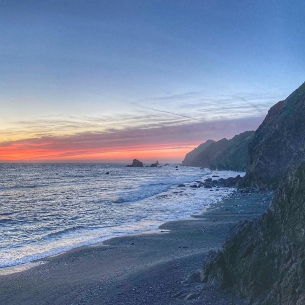
Humboldt County’s hotspots include the northern stretch of the Lost Coast known as King Range, Centerville Beach located five miles west of Ferndale, and the McNeil Creek area north of Trinidad Head.
Cal Poly Humboldt Professor Lori Dengler has spent her career exploring the North Coast’s seismic activity and the tsunamic hazards along our coastline. The coastline between 39-41 degrees latitude “consistently has the largest” waves, Professor Dengler said. With these larger waves plus high rainfall typical of the region, “you have all the ingredients for high erosion.”
For those that might be concerned that cliff retreat and sea-level rise could erode the iconic cliffs of the Coast, Professor Dengler said she doesn’t “think the bluffs will erode away completely anytime soon – the uplift is growing the coast at the same time.”
Del Norte County made the list approximately two miles north of where the Klamath River enters the Pacific. Those cliffs are also crumbling faster than most of the others in California.
The Lost Coast is California’s most remote and least developed coastline. The untouched, primordial condition could be one of the contributing factors to its higher rate of retreat. The totality of the Lost Coast is considered “unarmored”, as opposed to “armored” which describes the installation of seawalls and riprap at the base of coastal cliffs to mitigate erosion. Cliff armoring is a common strategy employed in Southern California to reinforce and mitigate erosion, often associated with seaside development.

Likely, the last photo of the Centerville Cross as taken from the beach just before it was rescued from a crumbling cliff in 2017. [Photo by Dorre Kidd Howard]
Another commonality noticed by researchers between cliffs collapsing the fastest might seem counterintuitive: cliffsides fronted by beaches retreated twice as fast as those without. Though a wide, sandy beach could suggest a barrier to protect cliffs from wave action, researchers found that beach sand, stirred up by incoming waves, acts an abrasive, eroding the lower sector of a cliff. Caspar Beach, Usal Beach, large swaths of King Range, and Centerville Beach all feature sand beaches that end abruptly at steep cliff walls.
In 2016, Centerville Beach’s eroding cliffs threatened a historic cross which memorialized the 1860 sinking of a steamer known as the Northerner off the coast. The cliff underneath where the cross had been installed began to collapse and the Native Sons of the Golden West volunteered to bring the cross to safety in January of 2017 before it tumbled down.
This research was the outgrowth of California State Assembly Bill AB-66 which funded scientific research to build a deeper understanding of California’s coastline, coastal bluff failures, and the possible development of future alert systems to warn communities of cliff failures. Essential infrastructure including highways, public access points, homes, military bases, power plants, and railways are located along California’s coastline and are vulnerable to erosion, retreat, and collapse.
![Cliffs meet the Pacific Ocean along King Range National Conservation, the BLM managed northern stretch of the Lost Coast [Picture from the Bureau of Land Management]](https://kymkemp.com/wp-content/uploads/2022/08/297653535_629947922063461_1955498745341378619_n.jpg)
Cliffs meet the Pacific Ocean along King Range National Conservation, the BLM managed northern stretch of the Lost Coast [Picture from the Bureau of Land Management]

A map from Scripps graphically demonstrating the Lost Coast’s significantly higher rates of cliff retreat than the rest of the California Coast
Now, the stretch of coastline referred to as the Lost Coast which hosts multiple cliff retreat hotspots is actually made up of two separate designated wilderness areas.
The federally managed King Range Wilderness makes up the northern section of the Lost Coast, beginning just south of where the Mattole River enters the Pacific and ending near the town of Shelter Cove.
The southern section of the Lost Coast lies within Sinkyone Wilderness State Park, managed through a partnership of ten indigenous tribes known as the InterTribal Sinkyone Wilderness Council and California State Parks. Sinkyone Wilderness begins at Needle Rock Visitor Center and runs south to Usal Beach, a popular car camping destination.
![Usal Beach, the southern terminus of the Lost Coast [Photograph from CAL FIRE Mendocino]](https://kymkemp.com/wp-content/uploads/2022/08/295350284_336198811975226_8276484250051069106_n-1.png)
Usal Beach, the southern terminus of the Lost Coast [Photograph from CAL FIRE Mendocino]
Researchers behind the Scripps study intended for their data set to inform coastal planning and development, essential in California where millions live a stone’s throw from where the American continent drops off into the Pacific. The oceans are rising. Policymakers in Mendocino and Humboldt County have already begun to consider the implications of this on our coastlines. Knowing sections of our coastline are crumbling at a record rate, perhaps local leaders will face the challenge of mitigating the negative effects of sea-level rise with a renewed sense of urgency.
Join the discussion! For rules visit: https://kymkemp.com/commenting-rules
Comments system how-to: https://wpdiscuz.com/community/postid/10599/
up, see like iv’e been saying, global warming is coming for us all, be afraid, oh no what should i do, thats right ,joe biden will fix it
Or maybe just be careful and adapt… Not unlike politics itself.
Sleepy useless joe is sending all our taxpayer money to Ukraine!
The only mention of global warming is your comment.
While not using those words, the last paragraph (and the cited study) does use “rising sea levels” as a motivation for the study.
Kind of a givin’ that we would have the most cliff collapse. We are on the East edge of the San Andreas fault, tall growing mountains, and wild weather.
Maybe the highway department should consider moving the “Last Chance” highway inland. Mother Nature always wins. (I didn’t even need a five million dollar study to figure that out.)
Absolutely. And wide sandy beaches at the base of cliffs? Uh… as the cliffs erode and the waves pulverize the debris that fell down, it’s going to make a beach. That material is going to be higher in elevation than the tide line. That’s not a $5 million dollar study. That’s common sense.
I always look left at the old 101 when going south over the huge bridge at confusion. Is that last chance grade? I remember when the confusion side was being studied and worked and after a gazillion dollars they decided to build the bridge. Crazy.
Last Chance Grade is south of Crescent City, where the eternal road repair project is going on. And on. And on.
Last chance grade is north of the lagoons and south of crescent city. It’s an active stretch of highway 101 that is continually collapsing into the ocean
Did you notice the highway has sunk again on the north end of Wilson creek bridge? Caltrans has been dumping asphalt in that 1/4 mile hole every few months for 50 years.
We live in a semi-liquid state…
Here’s hoping that the study does not lead to “cliff armoring” and home development.
Probably the best ever construction project on 101 was the “half bridge” just north of Bridges Creek. I am still in awe of it when I see it going northbound, and miss driving on it, even with a 20mph limit.
?
A sincere question about Last Chance and other endangered stretches of 101 (Oregon). It’s a federal highway, right? Are the states, CA,OR< and WA responsible for this or do the Feds have some responsibility?
Also, sand cliffs will crumble, it’s what they do. Sadly for those who live on them.
I was told as a kid the feds pay for the roads that are federal as long as the drinking age stays 21…
Anyone know if this is legit?
I’m not sure. I do know that Alaska had (until the early mid 80s, legalized weed (you could grow your own, if I remember right up to three plants) and the drinking age was 19. The Reagan admin threatened to withhold federal funding for transportation if they didn’t change those to straight up illegal cannabis and the drinking age raised to 21.
The federal government threatens to withhold road funds if certain criteria aren’t met. This includes drinking age and maximum speed limits
Why not listen to NOAA? Keep your shoreline alive!
Don’t forget while sea level is rising the area around Cape Mendocino
is experiencing uplift.
A 7.2 earthquake a couple of decades ago left Urchins on the hard
when before the quake they were in 4′ of water.
Hiking our coastal trails gives one a good idea how fast the cliffs are changing. I need to remind myself each year to expect radical changes to the trails from one season to the next.
It’s something to think about when hiking those beaches along the cliffs south of Centerville. The steep drop off of the ocean, the sharp sand cliffs just before reaching the real cliffs and the cliffs themselves make a really different beach experience. It was always enticing but a bit ominous. Easy to get caught between the ocean and the crumbly cliffs try to squeeze around the next bit of narrow beach between cliff and ocean with the brain saying be careful at the same time it says “I wonder what’s on the other side.”
There was a bluff at Pt. Reyes that collapsed while people were hiking on it back in 2015, ever since that I have avoided similar trails.
All this stuff like this that’s happening before our eyes, we get to witness the planet evolving.
Business as usual with bureaucrat-academic cartel.
Time, climate cycles, and geology, humans are what’s for breakfast and there is no getting off the menu for anyone. Good luck!
Fascinating story. Thanks for covering this. I’d be interested to know how this measurement is done. Also many of the cliffs have native village sites. How do they deal with that?
LIDAR is the method used to measure changes.
Hard not to lose ground while thinking of this very fluid situation.
Armor the cliffs, lose the beach. Erosion is natural. The beach always stays the same size, the coastline moves back. Armor the coastline and the ocean eats the beach. Then you lose the cliffs 10 years later anyway.
On sandy beaches on the west coast of the northern hemisphere, we can use geo-phyto techniques, taking advantage of the sands that have eroded due to past hellacious logging practices.
The Celestre Property in Manila is a stunning example, with our grasses intact we’ve actually grown a 30′ Primary dune producing a deflation-plane wetland for our native plants and wildlife to the west of the former vegetative line.
On the Celestre Property, we are expanding freshwater habitat during a period of sea-level rise, just by leaving it alone!
The removal of vegetation on our coast has been destructive to habitats, wetlands, and wildlife at every site, reversing our forests’ march to the west and destroying any hope for resilience.
Where are the journalists?
Did they subvert the will of God when they kept that cross from falling into the sea? Just wondering.