
Odd Old News: Afloat and Afoot, Travels Through Mendocino County Into Humboldt, Pt. 1

Frog Woman Rock [Image from the 1860’s]
In April of 1881, the good Rev. James R. McDonald left San Rafael where he was the pastor of the Presbyterian Church for a journey to Humboldt County. In the company of “prospectors and locators,” Reverend McDonald journeyed via railroad, stage, horseback, and finally by boat down the Eel River nearly to its mouth on a 17 day journey which took “a much longer time than we anticipated.”
In the fall of 1881, the Humboldt Times featured Reverend McDonald’s long running account of the travels of the party, which we will feature over the next few weeks. [Please do remember, we are reproducing his words faithfully and some of them reflect the bigotry of the time.]
This week in Odd Old News, the adventurers start in San Rafael on the North Pacific Railroad, take a stage from Cloverdale north, passing by Frog Woman Rock. The linked article provides a more in-depth coverage of the Pomo legends of “Frog Woman Rock.” Frog Woman is an important figure in Pomo beliefs. The prominence was initially known by the Euro-Americans as “Lover’s Leap” and “Squaw Rock.” In 2011 its name was changed back to Frog Woman Rock, or kawao maatha qhabe (pronounced Kawow Maata Kabe in the Central Pomo language).
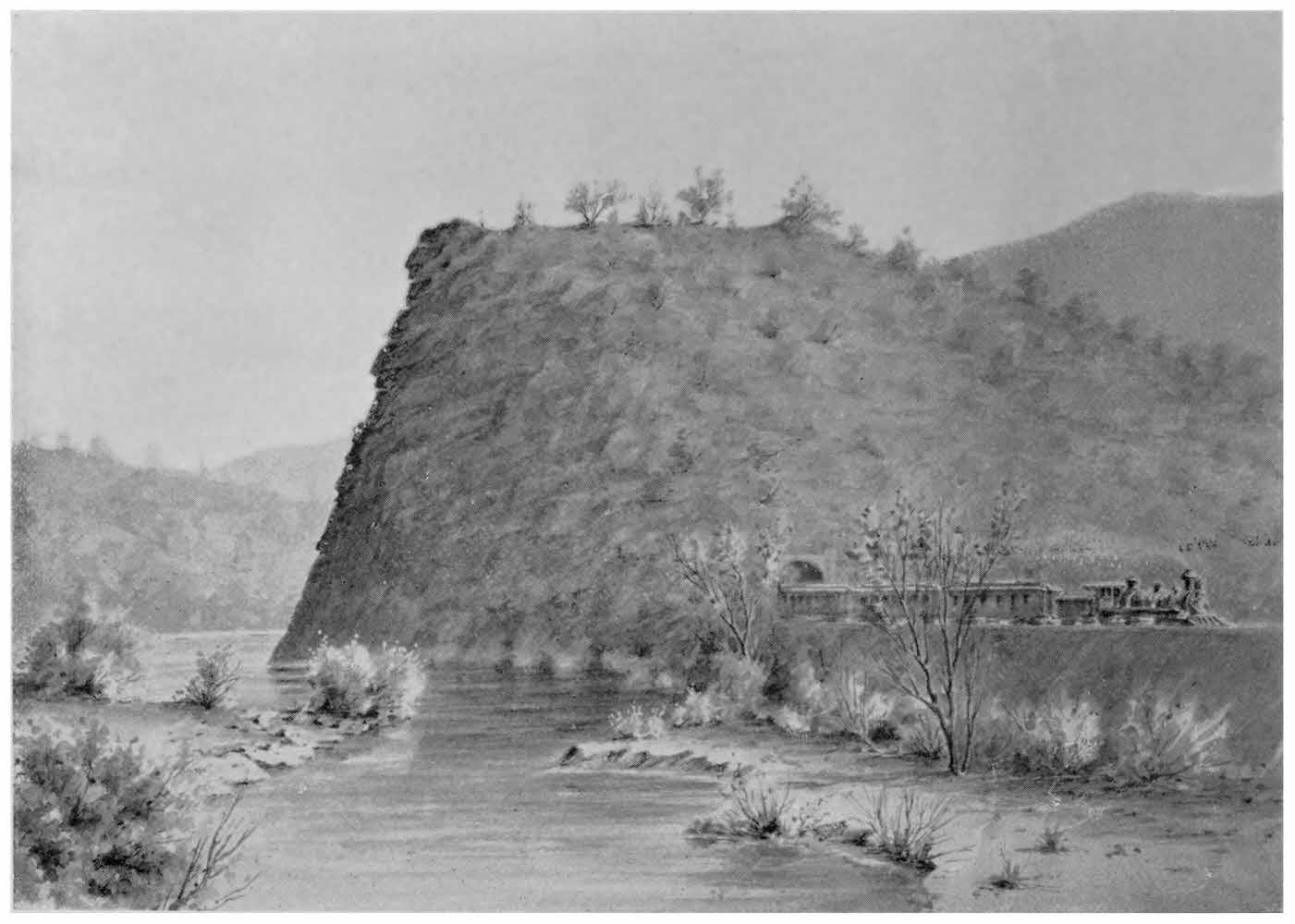
Train exiting the tunnel in Frog Woman Rock [Image from a promotional brochure of the San Francisco and North Pacific Railroad]
Likely traveling on River Road, the party passed by the new Yokayo Rancheria on the east side of Ukiah Valley. Obviously unaware of how hard the Yokayo tribe had worked to pay off the land for their Rancheria, Reverend McDonald could not refrain from disparaging the lifestyle of those Pomo he saw.
During the party’s stay near Ukiah, Reverend McDonald, described as a “courteous Christian gentleman”, revealed his fondness for food, an aptitude that qualified him for the rank of expedition Commissar. Read along for first few weeks as we follow their travels north to the Eel River and the scene of a memorable river adventure as recounted through the eyes of a minister.
DOWN EEL RIVER–Afloat and Afoot, Pt. 1
By Rev. Jas. R. McDonald
Humboldt Times
September 17, 1881
THE START—SCENERY—UKIAH—THE COMMISSARY—TROUTING—UNSAWED LUMBER—SHEEP RAISING-SLAUGHTER OF DEER
Our party, consisting of three men left San Rafael April 25, via the N.P.R.R. to Cloverdale. We skirted along for twenty miles between foothills and bay, through pastures, rich and green that were a paradise for the sleep dairy cows that fed in contentment along their streams and on their sunny slopes.
The wildflowers, blooming in their glory, beautified the landscape. Sometimes in their thickly clustered brilliancy, they looked like cloth of gold spread out upon the green award. Again they charmed the sight with their mingled shades of blue and golden, of purple and white, encompassed and interspersed with the green of luxuriant grass.
Within an hour we had passed through Petaluma, a busy, prosperous town at the head of navigation at the northern extremity of San Pablo bay. Onward we went through the broad Santa Rosa valley, long stretches of which seem too damp and cold for successful cultivation; and through its metropolis—an attractive county seat—and on, over a very poor farming section, and across the river to Healdsburg, in the midst of the enchanting scenery of the lovely Russian River Valley.
We are in ‘Sotoyome”—“The valley of flowers.” The hills on either side close in upon the charming valley as we go onward to Cloverdale, the terminus of the railroad. There the chief of our party secured a team, and we started leisurely on our journey of observation up Russian river, with the design of following it to its headwaters and examining the divide between them and those of Eel river.
My companions were the scientific and business men of the party. They carried a few instruments that they frequently used by the way, taking notes as they deemed advisable. As a guest of the chief, my trip was taken for recreation and pleasure. In order to impart to me something of a business air, and give me a deeper interest in the expedition, I was intrusted with the care of a thermometer and a map. Of their disastrous fate you will hear farther on in this narrative. My dignity and importance were enhanced the following day, when I was made chief commissary, and laid in our supplies for camp life.
The scenery up the Russian river canyon is exceedingly picturesque and attractive. The road follows the river very closely for several miles, and does not leave it very far, at any point between Cloverdale and the confluence of its main branches above Ukiah.
The grandest and most striking feature of the river is the lofty and almost perpendicular rock that rises from the bed of the stream in the narrowest part of the gorge, and is known as “Lover’s Leap”, or “Squaw Rock.”An Early View of the trail that became Hwy 101 passing Squaw Rock [Image origin unknown]
According to its pathetic, highly wrought, legendary history, this rock was the scene of a tragedy. Here a broken heart, with its last expiring throb, wreaked vengeance upon the fickle brave who crushed its hopes and blighted its glowing visions of happiness. The legend relates that a chieftain’s daughter, a high born, charming, dusky maiden of the tribe, disappointed, desperate, presumably agile and powerful (or she never could have done it), leaped from the summit of the rock, clear of the projecting sides, upon the handsome, and, to her, false and heartless love, and his bride who lay at the base in the sweet sleep of honeymoon, (if indeed the natives have such lunar seasons of wedded bliss).
These happy hearts had encamped at the fatal spot, unconscious of the fast that they had feasted for the last time on acorn soup and dried grasshoppers. It looked to our prosaic eyes, as if the reckless, desperate maiden would need a springboard if not a catapult, to send her clear of the rock; and also a keen and correct eye and an admirable poise, and arrowy flight, in order to land with one foot upon her bewitching rival, and thus extinguish them as she struck the rocky bed of the river, from which she could never arise if she failed in her first attempt.
[TO BE CONTINUED]

and
Humboldt Times
September 18, 1881
DOWN EEL RIVER
(Continued)
As we near Hopland, where we spent the night, the valley expands into a fertile farming region, encompassed by grand hills, which, as we journey on, again press close down to the river, sending us along near the bank for a short distance only, when we enter the lower end of Ukiah valley. We skirt around the eastern side, preferring this route to the stage road on the western side; and cross the river near Ukiah at a large Indian Rancheria, where we see nature both adorned and unadorned, where the lazy lounging men are lying prostrate in the sun, utterly indifferent about the dead-lock in the United States senate and trusting heroically to the women with their hair badly banged, to do the heavy work of the establishment.
The curiosity of Ukiah, the county seat of the vast extent of mountainous country known as Mendocino county, is greatly excited for a warm day, as we stop in front of the court house and examine the “nodometer” and note the distance from Cloverdale, thirty-six miles, and its elevation above tide water, seven hundred and fifty feet.Ukiah Valley, Mendocino County in 1867-1869 [Photo by M. M. Hazeltine located in the California Heritage Collection of the Bancroft Library at UC Berkeley]
One of the chief dignitaries of the county undertook to interview our leader, who was the only one authorized to answer any questions about the object of the expedition. But he had his own reasons for keeping quiet and we soon found that he could be almost as silent, under these frequent assaults of the curious and inquisitive, as the grand old Egyptian Sphinx, even when a destructive tourist, with ladder and hammer, is trying to chip specimens from its hard granite cheek. On the other hand, when he found a man who knew anything of the topography of the country, he showed that he was possessed of a remarkable faculty as an interviewer. He could ask more questions about streams, divides, canyons, distances, than a San Quentin investigating committee could ask about mileage of a director who had been meandering about the state in search of the Kearney street office, and drawing pay for all the miles traversed.
The valley and town of Ukiah give indications of energy and thrift on the part of cultivators, merchants, and mechanics. Some of its citizens are owners of fine sheep ranges, and some of its firms are purchasers of large amounts of wool. Here we obtained the services of a friend, who provided a team, and assumed the responsible position of chief cook. He is the owner of thirty fertile acres, on the border of the town, that produces the largest and most delicious gooseberries that we were ever privileged to eat. The soil and climate are most favorable for the production of this fruit. He has several thousand bushes that are bearing superior berries, and he is planting out more and more each year. So far, he has found a local market for them at a good price. With railroad communication with San Francisco he could secure munificent income from the berries, and from pears, that ripen when the depleted city market would welcome them.
As a cook, he can serve up a cottontail rabbit in a savory dish that would delight an epicure. Unpolished, genial, original, full of fun and good-nature, for many years a very profane man, but now one of genuine piety, an honored officer in his church, generous, steadfast, useful, he proved a most valuable addition to our party, and we parted with him when we abandoned the wagon road, with sincere regret. Our chief made him a liberal, urgent offer to mount a horse and go on with us to Alderpoint, but he could not go; and as things developed, it was well he did not undertake the trip.
Under supervision of the head of the commissary department, of whose qualification modesty forbids me to speak in extravagant terms, we laid in our supplies—except the ham. We were candidly informed by our merchant, that though he possessed hams; he had no goods in that line he could commend’ but that two miles beyond the town we could find the ham unrivaled. We found the ham, bought it, and found it excellent. Perhaps a choice cut from an Ohio corn-fed swine could surpass it. My pride in Ohio may influence my judgement in deciding such an important question, and lead me to give the California ham a secondary place. At any rate, it is an article of diet I have abandoned, save on such a camping expedition as this, when a keen appetite and the necessities of the case bring it into demand. There is no malicious design in all this to bankrupt any port merchants, or create a panic in the market; nor in mentioning the place of my nativity is there any intimation that I am an aspirant for any public office, not even for the superintendency of such Indians as we found at the mouth of the North Fork of Eel river. Since my rather brilliant administration of the purchasing department of the expedition down Eel river, my official career is ended, and there is no ambition stirring within me to enter into the service of my country in any public capacity. And that is all there is to say about the ham at present.
[TO BE CONTINUED)
![Ukiah Valley, Mendocino County in 1867-1869 [Photo by M. M. Hazeltine]](https://kymkemp.com/wp-content/uploads/2020/09/bk0004f2p9t-FID4.jpg)
Earlier Odd and Old News:
There are many, but here are the most recent:
- In Which Plans for Ferndale’s Fourth of July Parade Created a Masterpiece of Rage Writing
- Odd Old News: The Tragic Wreck of the Columbia Near Shelter Cove in 1907
- Crusade Against Blind Pigs in Humboldt County
- Back to Nature Man in Trinity County
- Building the Northwestern Pacific Tracks South to Ft. Seward
- The Bug Catcher Lady
- Holy Rollers Take Garberville
- Odd Old News: The 1890’s Opiate Epidemic in Humboldt County
- The Herstory of Two Women Sheep Ranchers in Mendocino County
Join the discussion! For rules visit: https://kymkemp.com/commenting-rules
Comments system how-to: https://wpdiscuz.com/community/postid/10599/
has anybody seen that tunnel through Frog Woman Rock?! I’ve still yet to explore the one at Scotia(?) and Table Bluff(?)
I was unaware there was a tunnel until I read this. Will have to look for it.
I’ve never done the Scotia one (I think you mean Shively), but I’d like to. The entrance point is always obstructed with low lying river water and brush. I’d also like to try to get into Bryan’s Bluff tunnel (Holmes / Larabee) but that seems much the same, difficult access due to low lying water.
I have done Table Bluff (reasonably interesting, easy to access) and Island Mountain. Island Mountain is sheer badass but hard to access as it’s between private property. I know the landowner (not Dean Wittier, the other one!).
Island Mountain —->
Very interesting stuff, I read all these with great interest
Often I think I was born 100 years too late
fellow was obviously being paid by the word…..
I was unaware there was a tunnel until I read this. Will have to look for it.
I’ve never done the Scotia one (I think you mean Shively), but I’d like to. The entrance point is always obstructed with low lying river water and brush. I’d also like to try to get into Bryan’s Bluff tunnel (Holmes / Larabee) but that seems much the same, difficult access due to low lying water.
I have done Table Bluff (reasonably interesting, easy to access) and Island Mountain. Island Mountain is sheer badass but hard to access as it’s between private property. I know the landowner (not Dean Wittier, the other one!).
Island Mountain —->
—>
David posts this stuff just to draw me out of hiding. The reason the we always called it “Squaw Rock” is because if you look at the top left corner of the rock in the photo of the rock with the train coming out of it you will clearly see the face of an Indian woman. I have a better photo of it that I will try to place in the comments when I find it. I don’t use the term “Squaw” anymore because it has become a derogatory term brought about by the cancel culture. I included a link to some very interesting Indian word history. Please read! It can bring a tear to your eye…
(By Marge Bruchac…)
“The sound “squaw,” regardless of its spelling, is OUR word for woman, and it is NOT to be used as an insult! When I hear it spoken by Native peoples, in its proper context, I hear the voices of the ancestors. I am reminded of powerful grandmothers who nurtured our people and fed the strangers, of proud women chiefs who stood up against them, and of mothers and daughters and sisters who still stand here today. In their honor I demand that our language, our women, and our history, be treated with respect.
Thank you for listening.”
Wlibomkanni, travel well.
Marge Bruchac
Link: https://lists.h-net.org/cgi-bin/logbrowse.pl?trx=vx&list=h-amindian&month=9912&week=a&msg=//Wt4lIoJcFuIg%2BP975gmg&user=&pw=
Thanks Ernie. I read it all. Awesome!
The following link is a very large file photo of “Squaw Rock” You can zoom in on the face to see why the rock was named.
(Photo credit: Janis Branscomb)
Nice!!
I think it looks more like Mel Brooks.
Thanks Ernie– and Janice! I was behind her in line today and forgot to compliment her, if you wouldn’t mind passing on my appreciation, please. Fun to compare to the brochure tunnel picture and note the tree positions.
This is the part of 101 where Rohnert Park police were ripping off weed couriers leaving Mendocino County.
Seem to recall hearing that area called the gauntlet.
Not sure that Frog Woman liked having a hole dug through her…. like the Eel River line, the track probably had six landslides in the first few years…. similar to the mudsliding under 101 in that stretch.
??Good read.
Dear Kym,
I am completing a PhD in Mythology, writing my dissertation on Frog Woman Rock. I cannot publish my work yet, but if you are interested in talking more about the rock, you are welcome to contact me. I have researched more than 5,000 newspaper articles about lover’s leaps in general and the tales attributed to FWR in particular, accompanied with folkloric analysis literature review. If you are planning to continue this story I am happy to direct you to interesting source material.
with love for the Spirit of this Place,
Kirsten
Kirsten, David is the writer of this piece and our local historian. I am sure he will find that interesting. Thank you.
Kirsten, that is wonderful, and I would love to correspond via email initially, if you don’t mind contacting Kym through her contact at the top. As I told Kym, I read through three or four versions of Frog Woman legends and they seemed to be very ‘white’, so I didn’t link to any of the better known ones… and was hoping to elicit a Native version. But this might not be the right venue for that. I hope that you will reach out. Thank you.
I was in tunnel #8 yesterday (9/24/20) with my son, old family friends have the property around here and we had been wading in R.R. before walking through 1/4 mile tunnel.
So cool!
Midway Tunnel 8
Creepy!
South end Tunnel 8
South SideTunnel 8
That is so awesome! Thank you for sharing these.