
Discover Humboldt: Capetown, California – A Glimpse into the Past
Capetown, California, is one of Humboldt County’s lesser-known historical gems, hidden away on the Lost Coast. Nestled between the towns of Ferndale and Petrolia, Capetown sits in a remote valley at the foot of the King Range mountains, close to the Pacific Ocean. It’s a place that feels like it’s been frozen in time, with its rugged terrain and deep historical roots reflecting the area’s early settlement days.
Today, Dock takes us on a journey to explore Capetown. Originally known as Gas Jet—or so it seems, since letters sent from the town’s post office were stamped with that name between 1868 and 1876—Capetown was once a bustling stopover point between Ferndale and Petrolia. Back in its heyday, the town boasted “a feed stable, post office, hotel, store, blacksmith shop, schoolhouse, hall, a dairy, and its necessary buildings.” The single wide street was lined with eucalyptus trees. Today, only a couple of those old trees stand, and as you drive through the town, you can spot their stumps as a nod to the past.
Earlier Discover Humboldt videos we’ve shared:
- Discover Humboldt: Baker Beach and the Doggies of the Sea
- Discover Humboldt: the Historic Company Town of Scotia
Join the discussion! For rules visit: https://kymkemp.com/commenting-rules
Comments system how-to: https://wpdiscuz.com/community/postid/10599/
Off to a rocky start. The King Range mountains are south of the Mattole River, many miles from Capetown. Hello– who makes these things up?
I checked a map, the statement is correct. Capetown is located in the valley at the foot of King Range. The valley stretches for several miles.
I’m curious what map you have. The only one I could find shows the King Range starting well south below the Mattole
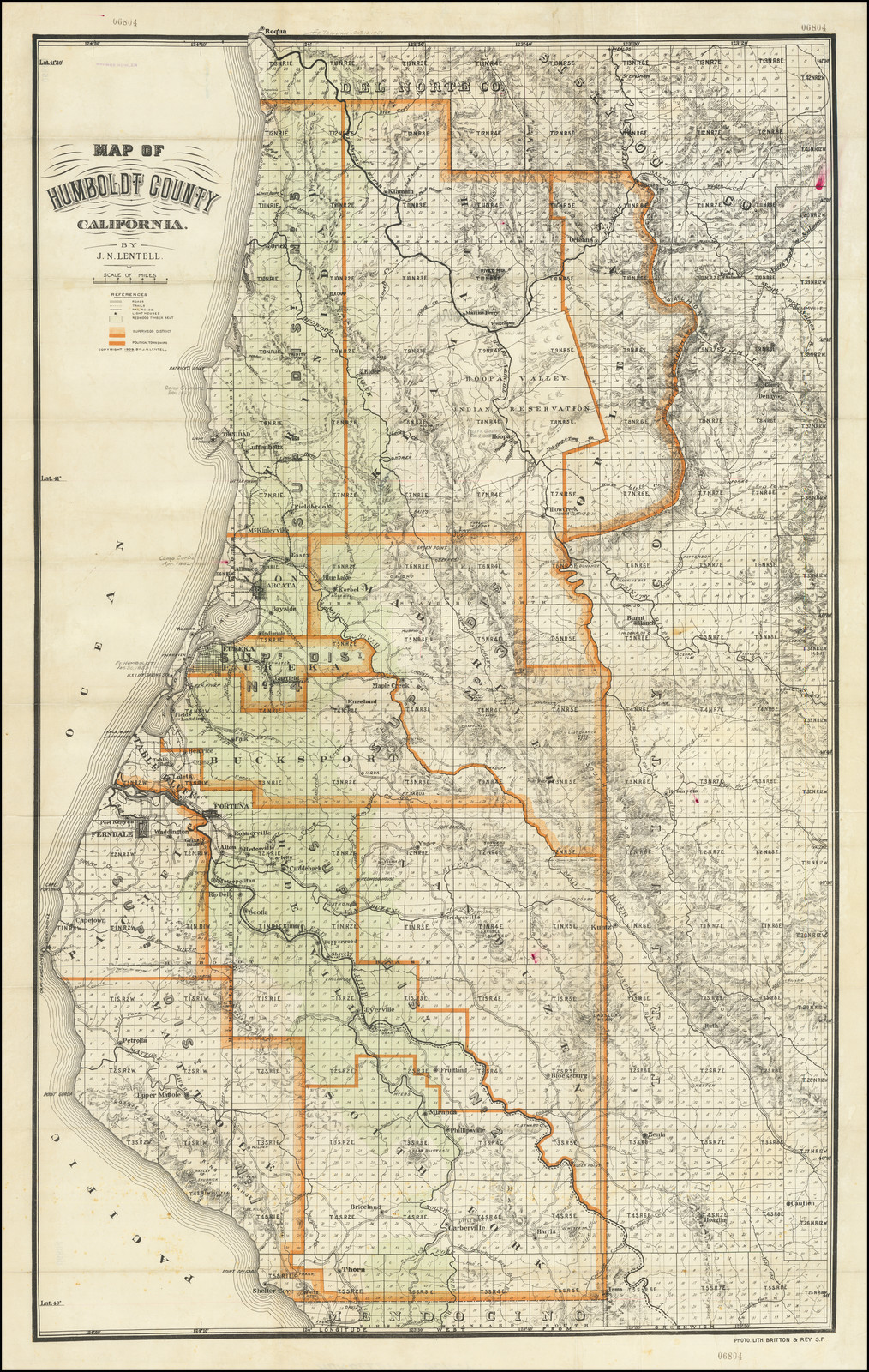
The Lentell map from 1909 shows the King Range marked below the Cooskie range which starts at the Mattole river.
Thanks for that map which verifies the name is Kings Peak with an s, contrary to what USGS etc, say.
Doolittle Map, 1865– not named
Coast Survey, 1871– King Peak
Forbes Map, 1886– Kings Peak
Lentell, 1898, and Denny’s, 1911– Kings Peak
Army Corps of Engineers, 1916– King Peak
Belcher’s, 1921– King’s Peak (at last an apostrophe)
Thanks!!!
You MIGHT find a map that showed Humboldt to the west and the Pacific Ocean to the east, as well, but that wouldn’t mean it’s so. Ask anyone who lives between Ferndale and Petrolia where the King Range is and i think, in this case, the majority opinion IS the correct opinion.
Please tell us more about that map. I’d love to see it!
I’m going to assume you have never been there. King Range is no where newr Capetown. That’s like saying San Francisco is by Eureka.
My understanding and on maps I’ve seen too — northern part of King Range ends at Mattole Beach. Maybe not so many miles, like less than 10 by bird from Petrolia to Capetown.
Was a shame they tore the old hotel/stage stop down. (Oh well.)
—
Old time ‘stops’ were about 15(+-) miles apart.
That was a days travel… with a horse-drawn wagon.
—
Eureka-Ferndale-Capetown-Petrolia-Honeydew-Ettersburg-Garberville.
That was a weeks travel back then.
—
Big Eucalyptus planting craze in California… first in 1870’s then 1915 (+-).
1900 (give or take one year) for the Bluegum Eucalyptus (including the World Champion specimen) on the Table west of Petrolia. Planted by stagecoach driver Jack Smiley.
Really? We have a Guinness Book Euc here? Is it due to age or size or both? I’d guess size. Probably some elders in the native Australia. Except for my Blue Heeler, I have no ties to that country, I just have a fondness for Eucs, particularly the Blue Gum. Is this World Champion specimen accessible to view? You’ve peaked my interest.
World’s Largest Blue Gum Eucalyptus https://www.roadsideamerica.com/map/13686
Thanks Melanopsin. Yes, go to the Petrolia Table Cemetery, it’s right there on the west fenceline.
Thanks
Google Earth will take you there !
This one, just a bit further northwest, is the actual World Champ (sorry about the sloppy screenshotting, but you can tell the location from this):
Thanks
*piqued* (French) not *peaked*
I just wonder where all the Wild Roses came from ?
(If you haven’t been there, there are thousands of rose bushes
(clumps) out in the fields.
—
Do you have an historical insight on that one ?
Wild Roses are native to Humboldt County and are fairly common throughout California. They are easy to identify by their simple five petal pink flower. Great habitat for birds and small animals. Browsed by deer and elk.
There are wild roses with white blossoms– not pink– on the hills between downtown Petrolia and the eucalyptus. They’re called Shields Roses, according to Buck Miner because a guy named Shields who actually lived in the New Jerusalem area planted a bunch and then they spread. The location of the Elwyn (not George) Lindley Bridge was where Shields’ Ford was– his land was the field below the bridge. I suppose there’s probably a more precise botanical name for these. They look a lot like the usual pink-flowered wild roses (five flat petals) except that the blossoms are white and maybe a little larger.
Thank you very much. Nice to get some local historical input.
I figured that somebody in the past had introduced them to that area.
They certainly took over the land !
Thanks Laura!
Where’s Brody? Did I miss something else?
This is fascinating. Road trip!
Love this video of our family’s little piece of heaven that we call Capetown. A couple years ago we put in a lot of work to the red and white schoolhouse and it is now an Airbnb. We kept the original structure and just did minor changes to the interior. We wanted to keep as much history as we possibly could because that’s what makes it so great. We have old photos of the history of Capetown covering the wall of the hallway and it really does feel like you’ve gone back in time. Check out our Airbnb at this link. https://www.airbnb.com/slink/Hfla3WT8
We are so happy to get to share Capetown with others and hope it brings others as much peace and happiness as it does to every one of us. Awesome video!!