
[UPDATE 6:20 p.m: New Evacuations] Shelly Fire in Siskiyou County Swallows More Territory, Forces More Evacuations
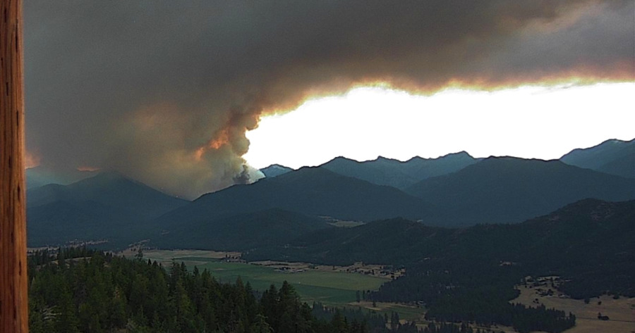
The #ShellyFire at sunset last night. [Image from the Fort Jones Camera on Alert California]
A Forest Service Incident Management team (CICIMT 12 (Conklin) is in Unified Command with CAL FIRE Siskiyou Unit, according to the Northern California Geographic Coordination center.
We’ve gathered the most important information about the Shelly Fire and organized it below for our readers.
Stats:
- Acres burned: 3,380
- Containment: 0%
- Personnel on the scene: As of last night’s update, there are 925 personnel working on the fire.
Compelling Images:
This collection of images from the Alert California system shows the speed with which this fire is growing.
The Plan: Zeke Lunder, a wildfire technology specialist that we follow, does a great job explaining the situation in his video below.
The Weather: According to the National Weather Service, there is an excessive heat warning for the area through tomorrow. They warn of “Dangerously hot conditions with high temperatures 105 to 115, and low temperatures in the mid 60s to lower 70s.”
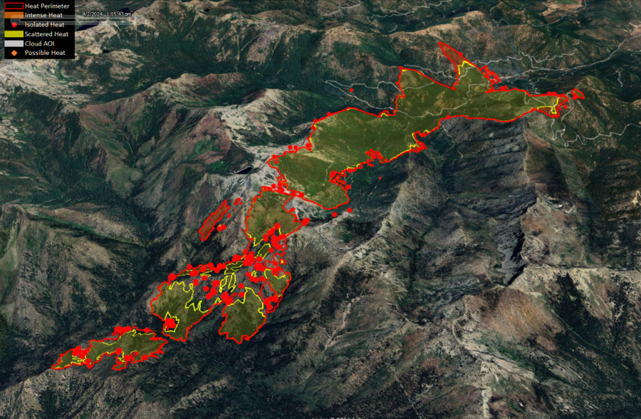
The Maps:
- Air Operations Map –to see details either zoom or click on the map and download a pdf.
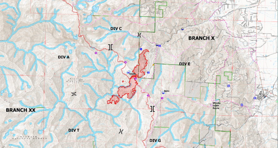
- KMZ Map–Zoom for detail or for 3D imagery, click on the map and download a file that connects with your Google Earth program.
Evacuation Information: Evacuation orders are in place for multiple communities. Evacuation Information here or here.
ALERTCalifornia Camera that can provide views of the Shelly Fire:
UPDATE 11:19 a.m.:
Press release from Klamath National Forest:
CURRENT SITUATION:
As of 7/7/2024 at 8:00 am the US Forest Service and CAL FIRE established Unified Command.Yesterday, under Red Flag Conditions, the Shelly Fire spotted over Kidder Creek and rapidly grew to approximately 1200 acres by 4:00 p.m. In response, additional resources including engines, hand crews, fixed-wing aircraft, and helicopters were deployed with the primary goal of safeguarding communities. Helicopters were utilized overnight, and the Siskiyou County Sheriff’s Office issued additional evacuation warnings and orders.
Today, the priority remains protecting the communities at risk. Air and ground resource will work on direct line control on the north side of the fire, while on the south side, resources will continue constructing handlines and working as close to the fire’s edge as safety allows.
Community meeting will be held tonight at 7:00 pm, location to be determined, please watch the social media sites and Incident websites for further details.
WEATHER:
An excessive Heat Warning through Tuesday with very unstable afternoon conditions continue. Today’s maximum temperature is forecast to be in the lower 100s in the valleys, minimum relative humidity 7-9%, and in the Kidder Creek Drainage up-canyon winds will increase to 7-9 mph late morning through the afternoon then shift to down-canyon 10-15 mph between 2:00 p.m. and 3:00 p.m.
EVACUATIONS:
Multiple evacuation orders and warnings remain in effect. For current updates on evacuations, visit www.facebook.com/SiskiyouCountySheriff and www.facebook.com/SiskiyouCountyOES
Additional evacuation information and a map can be found on the Genasys site at: https://protect.genasys.com/search?z=14&latlon=41.550694%2C-122.905589
???? ????? ????????? ?????? ?? ?? ?????? ?N ???? ?????? ??? ?? ??????.
?????? ?? ?? ??????????? ???????? ?????? ?? ??? ??? ?????????.
Kahtishraam Wellness Center – Yreka
1403 Kahtishraam, Yreka, CA 96097
Showers and cots are available.
RV Dry Camping/Parking
West Webb St. and Hoag St. in Montague
Please note, at this time, there are no extra services (sewage/water/power hookups). This is currently set up for DRY camping.
UPDATE 6:20 p.m.: New evacuation orders and warnings were issued just after 6 p.m. Read the details here.
Join the discussion! For rules visit: https://kymkemp.com/commenting-rules
Comments system how-to: https://wpdiscuz.com/community/postid/10599/
It’s a smokey one. From zoom.earth:
Thanks Kym. I hope everyone stays safe.
(Having a little whiplash here in Arcata with the sudden drop in temp.)
Heard it burned a few cabins up at kidder. I also had to evacuate, living so close to kidder.
I have not heard that…at all. I’m in FJ
My cabin would be one of the first in its path on N Kidder Creek Rd. To my knowledge the fire was still 2+ miles away around 9pm last night and the crews were set up outside my place.
Whoo HOO!
Packed up and ready to go (higher climes)
Sure could use some sleep
Thx Kym…the info is horrible-no briefings, no real contact with the public altho I understand there’s going to be a meeting at Etna High this evening.
Stay SAFE firefighters…
I love geeking out to Zeke during fire season…it’s kinda sad that it takes a threat to find any sort of mutual aid-the narrative ‘you do you’ doesn’t work (ever) when the forests around you are on fire.
Off to Watch Duty ~
is that KMZ file updated regularly? or just a one time snapshot?