
Deep Fire Near Trinity Lake Holding at Almost the Same Acreage as Yesterday

Fire activity near Deep Creek from 4:00 p.m. on August 25. The 30-acre run will likely run into rock scree and stop. [Photo: Kevin Tidwell/Alameda Fire Department]
CURRENT SITUATION
The Deep Fire was mapped overnight at 3,838 and remains 58% contained. Good work continued yesterday. Several areas continue to hold heat, specifically in the northeast and southeast corners of the fire, but there the fire has remained within proposed containment lines.
On the southern end of the fire, crews adapted their traffic pattern to avoid the Trinity Alps Resort as it reopened for business yesterday. Residents and visitors are advised that despite good containment progress, there is still heat remaining inside the fire footprint and fire-weakened snags could pose a considerable threat. A Forest Closure remains in effect in the area for public and firefighter safety, and smoke is likely to be visible for the foreseeable future.
On the southern and southeastern edge of the fire, crews worked primarily directly along the fire’s active edge, mopping up, extinguishing hot spots, and making sure no burning material is close enough to the line to pose any threat to containment. They were able to complete line to Sunday Creek, effectively containing the fire’s southeastern edge. They will continue to improve that line today.
Up the Stuart Fork Trial, multiple resources remain in place, ensuring that mitigation measures are in place as smoldering material continues to roll off the steep slopes above the trail.
The fire continues to back into the Little Salt Creek drainage on the north end of the fire. Activity was observed there yesterday as fuels warmed and dried. Crews utilized helicopters to cool the edge as a small finger of fire moving through continuous fuels flanked across the slope. Fuels in the area are sparse, and the fire remains positioned to run into rock.
MAP:
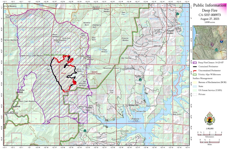
Map of the Deep Fire
WEATHER: According to the Shasta-Trinity National Forest Service statement this morning, “The warming and drying trend of the last few days will continue through today, bringing light diurnal winds. A change is anticipated Monday and Tuesday as an upper level trough moves through the fire area, bringing the potential for westerly winds and slightly cooler temperatures.”
ROAD CLOSURES: There are currently no road closures associated with the Deep Fire. For information on roads in the area, visit Caltrans QuickMap.
FOREST CLOSURES: There is a forest closure associated with the Deep Fire. Deep Fire Area Closure Map and the Closure Order.
EVACUATIONS: For the most up-to-date information on evacuations in Trinity County go to https://tinyurl.com/29f8uwmk
Important links to also watch:
- Trinity County Sheriff Department
- Shasta-Trinity National Forest Facebook
- Deep Fire Facebook page
- InciWeb
Earlier:
- Red Flag Warning Issued as Lightning Strikes Pepper the Emerald Triangle
- Powerful Lightning Storm Leaves Multiple Fires to Combat in Northwestern California
- Lightning-Sparked Wildfires Stretch Resources in Northwestern California; Head Fire in Siskiyou County Estimated Over 3000 Acres
- Wildfires Unleashed on Northwestern California: Thousands of Acres Covered by Flames, Evacuations Ordered Following Lightning Storms
- The Deep Fire, West of Trinity Lake, Estimated to Be 1000 Acres
- Battle Against the Deep Fire: Firefighters Confront Challenges in Rugged Trinity County
- The 3,662 Acre Deep Fire Continues Uncontained in the Rugged Terrain West of Trinity Lake
- Deep Fire: Rain from Hurricane Hillary HelpedPositive Signs: Deep Fire Stays Put and Firefighters Hold Strong
- Good News! Deep Fire Containment Now at 51%
- Good News Again on the Deep Fire, 58% contained
- Deep Fire Gets More Active with Warmer Weather


Join the discussion! For rules visit: https://kymkemp.com/commenting-rules
Comments system how-to: https://wpdiscuz.com/community/postid/10599/
Pleased to hear that the fire near Deep Creek is going fairly slow and should stop at when it reaches rock scree. As usual great fire control by our wildland firefighters. Hopefully it will soon be completely out.
Test