
The 3,662 Acre Deep Fire Continues Uncontained in the Rugged Terrain West of Trinity Lake

Pack String on the Deep Fire. [Photo from InciWeb]
Tonight, on August 21, 2023, an important community meeting is set to take place at 7:00 p.m. at the Veteran’s Memorial Hall in Weaverville, California. Authorities are gathering with the community to share crucial information on how best to tackle the fire’s progression.
In recent days, the firefighting crews stationed on the scene have witnessed a slight reprieve, as the fire’s behavior moderated due to higher relative humidity. However, the top priority remains the protection of vital infrastructure and important sites, including the Van Matre inholding, the iconic Trinity Alps Resort, Bridge Camp Campground, private timberlands, and key trail bridges. Efforts have been focused on fortifying structures, with the placement of sprinklers and hoses strategically designed to stave off any potential advance by the encroaching flames.
As the battle rages on, firefighters are sparing no effort to secure the area. Sprinklers have been left operational even when firefighters are not present, and response teams stand ready to defend against any new outbreaks. Simultaneously, dozers are being strategically deployed towards the wilderness’s edge to prevent the fire’s southeastern spread. In preparation for contingencies, alternative lines are being constructed, should primary plans prove ineffective in halting the fire’s advance.
One of the most pressing challenges faced by firefighters has been the persistent rollout and embers from burning snags, which have been crossing the Stuart Fork on the western perimeter of the fire. The firefighting crews have been relentlessly tracking down and extinguishing these sparks, effectively holding the line at Stuart Fork.
In the battle to control the fire’s spread, certain areas have posed unique challenges. The northern edge of the fire has been held in check by the natural barrier of Little Salt Creek. On the eastern front, the flames have been making slow but steady progress towards a prominent high-elevation rock outcropping, a defining feature of the fire’s boundary.
Adding a layer of complexity to the situation is the potential influence of Hurricane Hilary. Forecasts suggest the fire area might experience increased winds ahead of the approaching storm. With the possibility of considerable precipitation impacting the fire, managers are working on plans to ensure the safety of firefighters on the ground. Potential hazards include wind-driven fires, falling trees, and unstable soil.
A forest closure order is currently in effect due to the Deep Fire’s unrelenting rampage. For the latest information regarding forest closures, concerned parties can visit here and see the map here.
Also of interest, the Lookout’s view of the fires burning across northwestern California:
MAP:
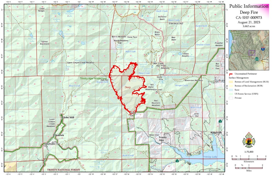
Map of the Deep Fire
WEATHER: According to InciWeb, “Hurricane Hilary may bring increased winds through the fire area in advance of the coming storm. Considerable precipitation may impact the fire, and managers are making plans to keep firefighters on the hill safe should the area being impacted by wind, falling trees, or unstable soil.”
ROAD CLOSURES: There are currently no road closures associated with the Deep Fire. For information on roads in the area, visit https://dot.ca.gov/
FOREST CLOSURES: There is a forest closure associated with the Deep Fire. For current information on forest closures, visit https://www.fs.usda.gov/detailfull/stnf/alerts-notices/?cid=stelprdb5392380&width=full
EVACUATIONS: For the most up-to-date information on evacuations in Trinity County go to https://tinyurl.com/29f8uwmk
Important links to also watch:
Earlier:
-
- Red Flag Warning Issued as Lightning Strikes Pepper the Emerald Triangle
- Powerful Lightning Storm Leaves Multiple Fires to Combat in Northwestern California
- Lightning-Sparked Wildfires Stretch Resources in Northwestern California; Head Fire in Siskiyou County Estimated Over 3000 Acres
- Wildfires Unleashed on Northwestern California: Thousands of Acres Covered by Flames, Evacuations Ordered Following Lightning Storms
- The Deep Fire, West of Trinity Lake, Estimated to Be 1000 Acres
- Battle Against the Deep Fire: Firefighters Confront Challenges in Rugged Trinity County


Join the discussion! For rules visit: https://kymkemp.com/commenting-rules
Comments system how-to: https://wpdiscuz.com/community/postid/10599/
Looks like moisture is tracking south-west.