
Slides, Downed Trees, and Wild Waters: Images From 2022 Year’s End Storm

The slide across Hwy 299 last night. The road is now open to one way controlled traffic but expect 20 minute delays. [Photo from Caltrans]
Rather than fill the page with words, here are videos and photos that we thought were compelling–moving progressively southward from images at the west end of Trinity County in the above photo from Caltrans to the most compelling image taken north of Willits at the bottom:
The Swollen Mad River [Video by Julie Rofman]

The Mad River beach entrance flooded this morning..
[ Photo by Julie Rofman]
The Eel River at Fernbridge this morning. The River reached flood stage and then crested around 9 a.m. [Video by Mike Grimaldo]

A tree fell across Hwy 254 this morning. [Photo by Jennifer Amidi]

The Eel River at the entrance to the campground at Fish Creek south of Benbow. [Photo by Brittany Tonks]

The Eel River south of Benbow near the Twin Trees bridge. [Photo by Brittany Tonks]
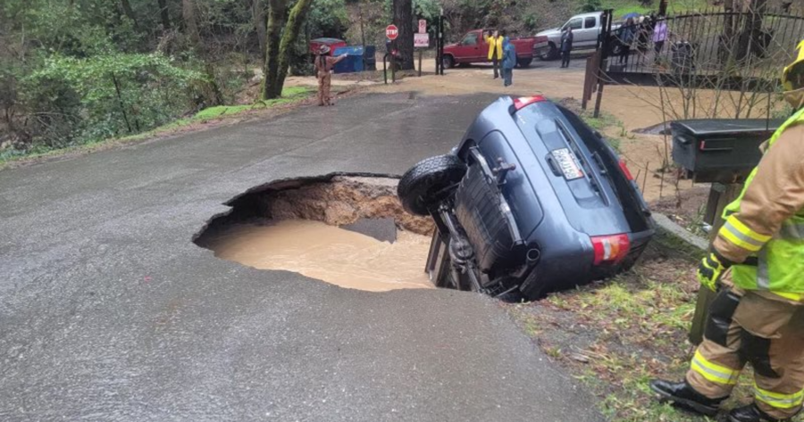
And, this iconic image from yesterday near Willits just off Hwy 101. The sinkhole nearly swallowed the entire vehicle. [Picture provided by Mendocino County Sheriff’s Office Captain Greg Van Patten]


Join the discussion! For rules visit: https://kymkemp.com/commenting-rules
Comments system how-to: https://wpdiscuz.com/community/postid/10599/
Sorry, but this is not just a grammar or spelling issue, but a specific geographical area and watercourse location: “The Eel River at the entrance to the campground at Fish Creek south” or “The Eel River south of Benbow near the Twin Trees bridge” is the South Fork Eel River. Am I right or am I wrong? Happy New Year!
Golly, let me be the first to congratulate you and say ‘your right’ Ed. Happy New Years!
You’re being phunny, right?
Are we still in grammar? Spelchek like to make “you’re” into “your”. This is all Ed Voices’s fault. Damn year sucks already.
For readers of RHBB your “corrections” are just rude. But we kind of expect that from you. What were you hoping to accomplish? I doubt embarassing yourself was on the list. The photo captions are accurate
What were you hoping to accomplish? That its the South Fork Eel River?
“One of the great challenges in life is knowing enough about a subject to think you’re right, but not enough about the subject to know you’re wrong.”?
I could call you Edward but it sounds a bit formal when we all know who I am talking about.
??,
True, but that would probably be preferable to being referred to simply as, “The Eel”…
???
Uh-oh! Is this a foible for the circular Pedantic and Picayune File, or am I just cranky?
So your justification for not calling it the South Fork Eel River is because “we all know who I am talking about”? What do you call the North Fork Eel or Middle Fork Eel or East Branch of the South Fork Eel River? Do you report on them as the “Eel River”? As a reporter, you are also educating the public and by referencing something with the wrong name is just foolish and lazy in my opinion!
If I am referring to the river running under the Alderpoint Bridge…I call it the Eel River. If I ever have to search official records for you, I’ll use Edward. But since we all know each other, I’m going to call you Ed and figure most folks are smart enough to know who I’m talking about.
I’m writing for locals, Ed. They know that SoHum is another term for Southern Humboldt. They know that Mendo is a term for Mendocino County, and, if I’m talking about the Main stem of the Eel River at Alderpoint…I can shorten that to the Eel and they won’t have a bit of trouble figuring out that it is not the South Fork of the Eel River. As a commenter, you are also educating the public and by fussing over something that literally no one but you is struggling with, you are providing a role model of what pedantic looks like.
Great! But umm don’t put a comma after “but”!
Your analogies are not working and you don’t write just for locals. If your argument was legit, you would not need to use fallacious ad hominem attacks to make your point…
Legit attacks like “foolish” and “lazy”?
Let it go.
The photo descriptions indicate location and fork by other means…
IE: “The Eel South of Benbow.”
That it’s the South Fork is therefore understood.
You understood it was the South Fork, right?
Yet you want it clarified…???
Why? Out of reverence?
It’s unnecessary.
It’s nearly as unnecessary as demanding that a picture described as, “The Pacific Ocean West of Shelter Cove”, be described instead as, “The Eastern Pacific Ocean West of Shelter Cove”.
That would be redundant.
“The photo descriptions indicate location and fork by other means… IE: “The Eel South of Benbow.” That it’s the South Fork is therefore understood. You understood it was the South Fork, right? Yet you want it clarified…???”
If you are going to quote something or use analogies stick the landing! i.e. “The Eel River south of Benbow near the Twin Trees bridge” or “The Eel River at the entrance to the campground at Fish Creek south of Benbow”.
In either case, denial is not a river in Egypt, nor does the Eel River flow anywhere near Benbow!
Well, fork you, too. Happy New Year! (?) (sarcasm font)
Typical Humboldt winter, climate change here and cal-Trans will have 299 open tomorrow.
So far, pretty typical. Last couple of years have been atypically dry. If the rain quits like atypical last year, we could still wind up dry. Big rain in SF and San Diego.
Here is a shot of Kimtu Road, West of Garberville, after the flood waters that covered it, receded…
Did Tooby Park flood?
??,
Sorry, but this is not just a grammar or spelling issue, but a specific recreational area and historical designation lesson:
“Did Tooby Park flood?”…
The proper, formal, inquiry would be…
Did,
“Tooby ‘Memorial’ Park”, flood?”…
Am I right or am I wrong? Happy New Year!
?♂️????
Thank you, I can appreciate the history lesson. However, it was referred to by the name Tooby Memorial Park from 1967-2004. In its inception was included in the County Public Park system and operation. When the Southern Humboldt Community Park Board took over its operation in 2004 from the County, it was no longer a public park, but being owned and operated by a private NGO (private property). The Tooby Family leased that land to the County for $1.00 a year to be used as a County Public Park, not to be given into private ownership. IMHO, it ceased being Tooby Memorial Park the day the SHCP took over its ownership of the land and it became private property.
That chimney and fire place at Tooby Park is the only remaining part of the Prior Family home, back when the Tooby and Prior Families were partners and purchased the Western Livestock Company’s ranch land, started a cattle company with the Prior family in 1903. The cattle company’s holdings were known as Tooby and Prior, Inc.
That Prior house at Tooby Park was partially damaged in the 1955 flood and wiped out in 1964. Its too bad the SHCP Board does not care to share any of that history about the Park land, including its historic land use by indigenes people.
It’s “Tooby ‘Memorial’ Park”.
https://norcalpulse.com/humboldt/parks/tooby-memorial-park
Hmmm….
Do you see Tooby Memorial Park listed on this map, and its from 2010?
https://humboldtgov.org/DocumentCenter/View/906/Park-Location-Map-PDF
Here’s what the Park Board say’s about it, they call it “The former Tooby Park”!
https://www.sohumpark.org/things-to-do/tooby/
https://www.sohumpark.org/about/history/
If you really what to know the truth and not the hearsay misrepresentation and BS of the SHCP Board, here is the documents from the Board of Supervisors meeting on September 8, 2004, when the County gave away Tooby Memorial Park to private interest (SHCP Board). I know, I was their to make public comments, along with other concerned citizens from SoHum, and along with the Tooby Family Attorney, arguing against it as well, just to save $5,000 in operational and maintenance cost per year. What a bums rush that was, the fix was in. And just look what the Park Board has done with the place, i.e. cut down Redwoods for lumber, took out the drinking fountain, the caretakers area and trailer looks like a homeless encampment and the one pit-pot sits over the well cap, with no hand washing provided! Yeah, great job Park Board…
https://drive.google.com/file/d/1tPjoYCggo-wamxLrCEVUF1iX4npYiS_7/view?usp=share_link
Stopped by the Park last summer and it seemed in disrepair and neglected. Thank you for clarifying the reason. Seriously.
Tooby Who?
Thank you!
You’re welcome.
Happy New Year!
As a local who went through the 1964 floods, it’s kind of hard to be impressed by weather .It was a once in a lifetime event for sure. The Navarro river flat was 15 feet under water, and the flat at Noyo would flood at high tide, from the river flows. Ah the good old days!
If I remember correctly Branscomb had almost 120 inches of rain that year!
The picture of the “horseshoe bend” in the river is taken from Benbow Drive, a little South of Benbow, a little North of Fish Creek, at the “dropped pin”…
(It used to be one of my favorite fishing holes…)
12 street Fortuna 12:30 today. Yeah, I’ve seen it almost to the top of the levee; but this is nice.