
Odd, Old News: The Round Valley Coal Fields and Map
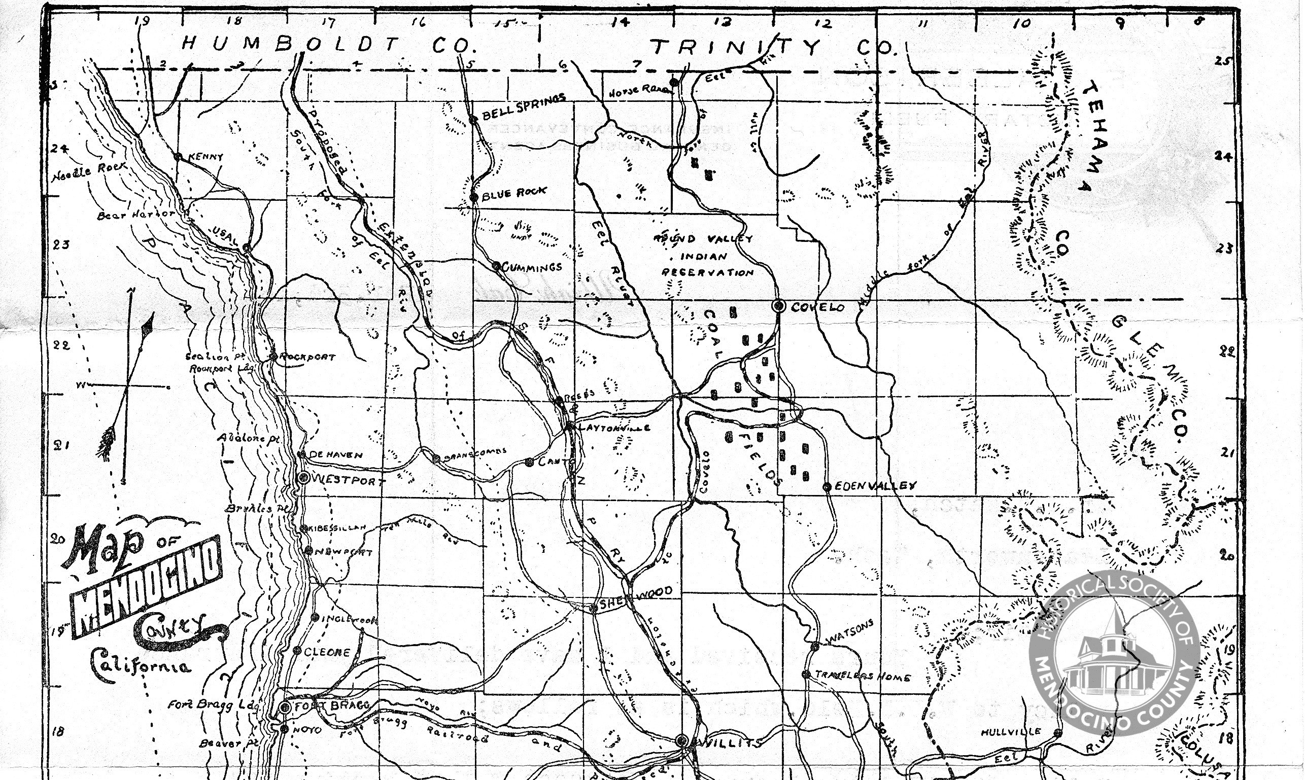
Mendocino County map circa 1900 showing railroad route plans and
the Round Valley coal fields, courtesy of the Mendocino Historical
Society
Nuggets of old news are served up by David Heller, one of our local historians.
Having previously reported on Coal in Humboldt County, Odd Old News returns to the topic of North Coast coal. This week we will take a look at some glowing 1890 news reports of the seeming enormous potential of the Round Valley coal fields. Initially these deposits were thought to be extensive enough to supply enough coal to take care of the heating needs of San Francisco. At this time California had virtually no coal mining, the state’s need for coal was supplied by train from out of state, and sometimes shipped from Australia, highlighting the importance of developing the Round Valley deposits.
As we have shared, the 1890’s were an era where railroad companies studied and surveyed a number of possible routes for track construction that would allow access to the coastal old growth redwood forest belt. Plans to develop the coal finds in Round Valley also spurred calls to have a railway to “where a mountain of coal lies undeveloped”.
One of the first plans for such a railroad line came from the Fort Bragg Railroad Company which was about to start digging the Glen Bair tunnel, and laying track up the Noyo River with intentions to continue on to Willits and Round Valley. Ft. Bragg eagerly anticipated this new development:
New Coal Beds
Humboldt Times
May 14, 1890
Rich coal beds have been discovered between Sherwood Valley and Round Valley of Eel River, which are claimed to be as rich as any in the world. An expert was up from San Francisco last week and Mr. Markle took him to them without any trouble, although he had not been there since ’68 Mr. Markle says the expert examined the coal found very carefully, and pronounced it to be as good as any he had ever seen, and from its formation and the quantity exposed on the surface of the ground, said the supply was inexhaustible.After some calculations the expert said to Mr. Markle: “This small piece of country between these two hills contains enough coal to supply the whole of the Pacific Coast for ten years.”
Mr. Markle says in one place a wide ledge of coal extends across the river which rises up perpendicular from the banks fifty feet high. A fine specimen was brought in which can be seen at the Fort Bragg company’s store. Those coal beds can be tapped by the Fort Bragg railroad and are about thirty-five miles from this place. The coal can be shipped from this port cheaper than any other way of transit. It is not likely that these coal fields will be allowed to remain long In their present undeveloped state, and we would not be surprised to see capitalists step in at an early day and work this vast mine of wealth. Fort Bragg, it is likely to presume, will be the shipping point of these coal beds, which means more business for our town—Fort Bragg Advocate.
The Ukiah press reported that four gentlemen had passed through enroute to the coal fields, where the men would be investigating the 23,640 acres coal lands that were owned by the Flood estate and John W Mackay. The quality of the coal led to the prediction of a coming “veritable mine of wealth to our county”. Humboldt county took note, spurring talk of extending their railway further south, or a possible direct track to the Shelter Cove port from Round Valley. Enthusiasm grew, and a railroad line from Willits to Sherwood Valley and west to the coal fields was proposed:
The Coal Mines
Humboldt Times
September 24, 1890There is much excitement in Round Valley over the coal mines. The Bank of Nevada owns 100,000 acres of coal lands near the junction of the two forks of Eel River. They have let it lay for years untouched, but are now spending $1,500 in prospecting it. A tunnel was run into the bed where there were some croppings close to the Middle Fork. At first the bed lay at an incline of 45 degrees, but as the tunnel ran in the slant decreased to 20 degrees. The bed varies in thickness from 8 to 14 feet, and has improved in quality as the tunnel went down.
At 140 feet water stopped the work. Pumps have been sent for. In the meantime work is being prosecuted on another tunnel across the river. The coal is pronounced an excellent article for use on railroads and steamboats. Mr. Flood, of the Nevada Bank, states that the Fort Bragg RR Co will build into Sherwood valley, where they will be met by the owners of the mines. It is the nearest outlet, and would greatly help the people of the Northern valleys. We sincerely hope it will prove to be more than an empty promise. The people of Round Valley are greatly elated over the prospects. Coal croppings are found along the range west of Round Valley for twenty or thirty miles to the north of the property of the Nevada Bank.— Republican-Press.
Large amounts of capital were needed to develop the coal fields and while there were wealthy backers, the path to development seemed strewn with legal complexities and complications:
EEL RIVER COAL
THE VAST FIELD IN MENDOCINO
Humboldt Times
October 30, 1890
Arrival of a Quantity Yesterday — Obstacles to the Way of Its Development — What the Owners Will Undertake.
[From the Examiner]
Winter is coming on, and that means more coal; manufactories ought to be encouraged in San Francisco, and that meant the same thing. It is useless to review the subject of coal famines in San Francisco, for it is familiar to everybody who is a householder.Yesterday there arrived in San Francisco ten tons of coal from Mendocino county. It cost $20 a ton to bring, but then that sum covered the cost of teaming sixty miles over a rough road to Ukiah, and thence by the railway. Someday, perhaps, these figures will be mentioned as one refers to the price of potatoes in 1849.
The coal was brought down by Jas L Flood from the middle fork of the Eel river. He owns three quarters of the property, and has been contemplating for some time past a development of the coal measures.As may be seen in the accompanying map, the coal field is situated near and in Round Valley. It extends six miles south and six miles north of the middle fork of the Eel river, and perhaps much farther. The coal is a lignite —that is, it is what is known as the latest formation of coal.
BEYOND MAN’S MEMORY
Long ago, thousands and tens of thousands of years, the glaciers swept down the eastern slope of the Coast range in Mendocino, carrying with them trees which were three and four times the size of the giant redwoods which now tower above the valleys. Stumps, with a vast acreage of roots, may be found nowadays hidden in the forest depths, denoting the mammoth growth in primeval days.
These were the forests that made the coal on the Eel river. The country shows signs of tremendous transitions. Volcanic action threw up ridges, out of which the coal seams crop. Extraordinary landslides must have occurred. In fact the surface of the earth has undergone all sorts of changes.
THE COAL VEIN
The middle fork of the Eel river is a lamb in summer and a lion in winter. At a certain point where two cliffs rise high on either bank may be seen the great coal vein, which it has cut in two. On either side the coal rises almost to the top of the cliff, and, according to the experts, there are 18,000 tons in sight.In the beginning of the seventies Isaac Friedlander bought land, which extended for twelve miles, to the extent of seventy-two hundred acres. It consisted mainly of what is called “offered” lands. Prior to 1860, when the Government surveyed a tract of land, it offered the lands included in the survey at $1.25 an acre at public auction. If the land was not purchased at the time it was offered it continued to remain in the market. All these offered lands were “called in” by the Government by the law of 1888.
The coal seam included in the present tract goes north to the Round Valley Indian Reservation and probably goes much further into Trinity county. It crops out occasionally on the surface, but according to the geologists it is full of “faults.” In other words, when the surface of the earth was forced up by volcanic action in ages past the stratum of coal was broken grievously, so that if a mine should be begun at the north bank of the fork of Eel river it might easily happen that after the progress of a few hundred yards the vein might come to an end, and the strata lie a hundred yards above, or below, as the case may be.
This is where the uncertainty lies, and it is just this that leaves the trail of speculation across the field.
When Isaac Friedlander failed in 1875, he handed five-eighths of the property over to the Nevada Bank; of the remainder, Walker of redwood fame owned an eighth, the estate of Edmund Janssen another eighth, and the late Captain RS Floyd the remaining eighth. Walker sold his share to the Nevada Bank later on, and whom Messrs. Hellman, Sloss and Gerstle bought a large share in the bank this coal property was one of the items reserved by Messrs. Flood and Mackey. These gentlemen realized the enormous expense required to open up the coal fields, but made a proposition, however, to Mr. Janssen that he should join in forming a stock company.Captain Floyd, It is said, was ready to enter into the enterprise with his accustomed public spirit. The Janssen estate objected, however, to the expense, which for a company of 100,000 shares would involve assessments of $45 or $50 a share. Then an offer was made the Janssens of $21,000 for their share, but this was rejected.
EXPERTS’ REPORTS
So now the matter hangs on the hooks waiting for the consultation with Mr. Mackay, who will arrive in a few weeks. There have been many experts on the property, and they say that the vein may average twenty feet in depth along its extent. At the river it is 600 feet wide on one side, and 350 feet wide at the other.A rough guess gives 10,000,000 tons to the square mile, and there are about forty square miles in the present tract.
It will take nearly $5,000.000 to put the coal on the market—$2,500,000 for a railway to Ukiah, and $2,500,000 to develop the mine.
From Ukiah the route would be sixty miles and practicable. There is another route discussed, namely, to Fort Bragg, on the sea coast. But this latter involves the question of loading schooners on an exposed sea coast. Lumber men know that this means a cessation of work during winter months, so that such a line seems hardly feasible.
There is, on the whole, a good chance for San Francisco to have a large and cheap coal supply—that is, if the promoters succeed in overcoming the obstacles.
The North Pacific Railway would join the proposed line at Ukiah, but this corporation cannot go farther, even at the inducement of the coal fields. When the Donahues mortgaged the road to the Seligmans for $6,000,000, it was expressly stipulated on the issuance of the bonds that the road should not be extended beyond Ukiah in any direction. However, there is no doubt the Donahue road would enter into a very reasonable contract, should an extension be constructed by Messrs Flood and Mackay.
By early 1891, the tunnel at the mine was 600 feet deep, and the fifteen foot coal ledge that was visible led experts to estimate an output of 1,000 tons a day once mining commenced in earnest. Though large deposits of coal had been found, work continued in order to find the main deposit. What happened to this coal mining dream is a story for another day, a Round Valley Coal Fields, Part Two.
Earlier Odd and Old News:
There are many, but here are the most recent:
- No Such Thing As Impassable Roads For Fool-Proof Modern Motor Cars
- A Parent’s Worst Fear Stories of a Century Ago
- The Wreck of the Steamer ‘Active’ North of Shelter Cove
- Early Adventures in Automotive Travel
- A Trip Up the Coast to Crescent City
- ‘Dope Evil Plainly Growing,’ Warns Early Eureka Newspaper
- A Real Fight With a Bear Up Mad River
- A Carriage Ride Down the Coast in 1892
- Lively Times At Klondike
- Drinking And Gambling Didn’t Mix


Join the discussion! For rules visit: https://kymkemp.com/commenting-rules
Comments system how-to: https://wpdiscuz.com/community/postid/10599/
Aww! Really left me hanging…Great story!
so interesting, can’t wait for part 2 of the story.
David Heller, local Penny Dreadful Cliffhanger author…. Drat.
David, I see that you finally found the Eel River coal that you have been looking for. I think that you may be the only one that will profit from the coal… By selling the story. LOL.
Actually Ernie, I was thinking of partnering up with the current mine landowner to sell lumps of coal closer to xmas time. Bio-regional and apparently sustainable stocking stuffers for the deserving…. if there be such in Round Valley….
Actually Mr. Heller, if it cost me less to heat my home with coal than firewood, count me in. I will buy it. And perhaps someone could design and build a simple transport box, for a pickup or trailer? Let’s go! Put PGE out of business. And please, don’t talk to me about pollution, we are surrounded by filthy growers who are draining and poisoning our water and forests. We heard they may dismantle the Alderpoint bridge, thanks to the growers, there is no more water to worry about.
Well, can you burn coal in a wood burning stove? If so, anyone with a backhoe could make some money. If you cannot, where would someone get a coal burning stove, and also, small coal fired steam generators? Better yet, could someone build coal heating stoves, and the boilers to produce electricity, and keep China and others out of the picture. We could set up a mini factory or two, people could have real jobs, instead of growing the poison they do now.
I have heard all kinds of stories about drilling wells in Round Valley (Covelo). In the mucky filling of Round Valley, they have dug up ancient redwood remains at unbelievable depths, and other strange remains from a historic upheaval of the Coast Range that formed Round Valley.
The problem today, as I understand it, is that the wells that they have dug into the huge aquifer is that they are sucking it dry. And, if they do that it will not return. The valley floor will sink into the former aquifer and it will not refill. However, if that is the case it will happen, I don’t think anyone will stop sucking water until it is gone. But, not to worry Mother Nature gets to bat last.
My house was built in the 20’s and had coal heat. I’ve found buckets of coal in my yard. I was told it came in via ship.
Anyone know anything about this?
If you live in London the coal came from Newcastle. You’re welcome.
Mr. Bear, that was how it was done, huge amounts of coal were shipped to west coast ports and distributed from there, much of it was transported eastward for the intercontinental railroad, as well as being the main source for heating homes.
Shipped from eastern US?
Thanks for the article. Love the geology information.
I like stars–One SF news article mentioned the great transportation distance to Eastern and English sources of coal that SF was dependent on in 1890. A quick online search said that Washington state was supplying 85% of SF’s coal in the 1880’s but that was down to 35% by 1890. At that time the Washington coal industry was the second largest industry in the state after lumber. My cursory search said that SF was a coal depot for the west end of the intercontinental RR….for a long time the large coal deposits of Wyoming were the main source for the Union Pacific RR line that was laid in part to pass through the region to access the coal.
Thanks David. Very interesting. I had not even considered the coal deposits in Wyoming and their relationship to the UPRR. I thought it’s route was picked based on geography/geology in that the “gangplank” and South Pass were the easy way over the divide. Thanks for the summer school lesson!
Great story, look forward to part 2.
David Heller might want to check with the Bartley’s at Noyo Hill House in Fort Bragg, as they have done extensive field work on those coal fields.
I assume David also knows about the small coal “mine” the Russians at Fort Ross worked in the early/mid 1800’s.
It is always a pleasure to have people think I know more than I do… that means my faking it is working! Those are interesting leads X-Mann, no I didn’t know about the Ft. Ross deposit…will have to check it out.
I think there are some clues as to the fate of the RV mine in the articles above, but really I don’t know what Part Two will reveal, it took me days to put this post together, and I will use the coming week(s) to try and compile more of the tale. I do know that SF didn’t get their coal source.
As we have shared, 15 years later, one of the advantages of the Northwestern Pacific RR route up the main Eel was that they could build a spur to the coal fields. So plans for development were still circulating that late. As we know, the competing plan for that route prior to 1906, was through Willits, Sherwood, Cahto, west to Branscomb and down the South Fork of the Eel River to the giant mill at Andersonia that didn’t open, and on north. These surveys and plans went up in flames in the 1906 SF earthquake and fire, making the Eel River route the default, for better and worse.
In the course of researching I found that Humboldt county’s Maple Creek coal occurrence was another almost big deal. My history ally at the Mendocino Historical Society who was so helpful in providing us with the map above, also shared some geology articles that showed that the quality of the RV coal was such that it left less ash than good Wellington coal, and I read where a burn test showed the Maple Creek coal on the Preston ranch left even less ash than the RV coal.
If next week I don’t write Part two, it won’t be because I am mean, I may need more time to coax info out of my luddite grade landline that takes serious siestas in hot weather.
ps. a RV local posted some current photos of the mine property on a previous post that I couldn’t find again… if they would like to repeat what they share, it would be welcomed!
Ha, take your time, I’m sure it will be worth the wait.
I appreciate your work in sharing local history.
And thanks to Kym for giving you a venue to post it.
David
That map is precious. It shows the proposed railroad through Laytonville. And, it Shows the old Sherwood road from Sherwood to Laytonville and also the more popular Strong Mountain Road from Sherwood to Laytonville.
The old map makers took great liberties with “Mapmaker Shorthand”. They leave out all the curves, wiggles and wobbles, that are actually in the roads and creeks.
Isn’t it though Ernie! You have a background familiarity with the N. Mendocino history and can appreciate its value. There are far fewer maps of Mendocino County than Humboldt County, and one from that era with all the old RR routes is worth a lot. The Mendocino Historical Society deserves a big thank you for sharing, and Kym for loading the map and post. I want to up my membership this week, if not for our Historical Societies preserving our history we would be quite bereft. I do so hope that younger folks will continue to step up volunteering and helping and joining our local counties’ Historical Societies.
And I must acknowledge that the map came to my attention because it was used in Mills of Mendocino County, written by Alice Holmes and Wilbur Lawson, and published by the Mendocino Historical Society in 1996. I wish there were a similar compilation of mills and locations for Southern Humboldt.
Interesting history. I will look forward to more
I took about a day and a half to go through the 1891-1906 news archives and found only great pronouncements of how this or that group was organizing, bonds were being issued, investors were lining up and the RR would happen soon to the coal fields. And then the articles got fewer and fewer. In 1905, experts were going there to clear debris from the entrance, a state mineralogy report from 1915 said the tunnel was blocked after 50 feet. I was expecting that to read that the 1906 EQ had impacted it, but found nothing. My guess, and I am still going to go through the news articles for another decade or two, is that our fractured geology took its toll, there was a lot of the grey clay around the vein. note to self: Don’t call an article Part one, unless Part two is ready, or known!
I am guessing this is why Rex bohn met with that company that wants to restore the north-coast railroad! I did some calculations and even if it cost Two billion to restore the railroad and another billion to develop the mines ,you could have a huge profit (it it exists)of perhaps tens of billions.Very curious to read part two!