
August Complex: 2020 Spawns California’s First Gigafire in Modern History
POSTED 11:51 a.m.
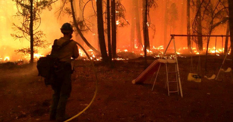
Firefighter protecting a child’s swingset. [Photo from the Lassen Interagency Hotshot Crew]
Climate scientists blame higher temperatures and more extreme weather for these behemoths.
![[Image taken from Alert Wildfire's Bald Jesse camera last night at 9:32 p.m.]](https://kymkemp.com/wp-content/uploads/2020/10/Alert-Wildfire-Bald-Jesse-10.6-9.32.png)
[Image taken from Alert Wildfire’s Bald Jesse camera last night at 9:32 p.m.]

The highly visible firing operation was held north of Zenia and east of Blocksburg last night. The large red marker is Coffee Pot and the other end of the red line is Big Meadow.
As a whole, with favorable weather on their side, firefighters managed to strengthen fire lines and even build a bit more containment.
In the Northwest Zone, according to a statement by the August Complex Management Team,
Firefighters made good progress in containing spot fires east of South Fork Ridge and north of Ruth Lake. Structure groups continued work in the Ruth Lake Area and near Journey’s End. Crews worked on constructing direct line from the Van Duzen Road east to Lake Ruth.
Today if conditions allow firefighters will continue firing operations in conjunction with work of structure protection groups to defend areas near Ruth Lake. Crews will continue to hold dozer lines east of Hwy (SR) 36 to South Fork Ridge. Fire personnel will strengthen dozer lines and contingency lines from the west side of Ruth Lake through the previous Gobbler and Lassics Fire burn scars to below Mule Ridge. Crews will be working to improve containment lines from Round Mountain to Kettenpom. More air resources will be relocating to the northwest zone and will be available to support firefighting efforts as visibility improves. As smoke blanket lifts, fire activity may increase and columns may become more visible.
In the Northwest Zone, according to a statement by the August Complex Management Team,
The control lines along Route 36 beginning at the west end, mile marker 64, were improved to reduce the threat of northward spread [yesterday]. The team partnered with CalFire to continue structure assessments and protection north of Route 36. A drone was flown along the South Mountain ridge to assist with firing operations.
A priority on Wednesday will be creating line along the fire perimeter near Round Mountain. The team continues its progress on contingency dozer lines northeast of the South Trinity River. Many hazard trees are being removed along the Route 36 corridor, with structure protection on the north side nearly completed. Two additional hand crews have arrived and are beginning work in the active Round Mountain area.
Tomorrow, the U.S. Marines from Camp Pendleton’s 7th Engineer Support Battalion, 1st Marine Logistics Group, 1st Marine Expeditionary Force will begin operations in this zone. They are forward-deployed to a spike camp and will field five 20-person strike teams comprised of ten 20-person crews that perform the full range of front-line firefighting tactics.
The Images:
Video credit: August Complex Management Team
For some amazing photos from the Lassen Interagency Hotshot crew, click here. Below is one example.

Firefighter in a burning forest. [Photo from the Lassen Interagency Hotshot Crew]
The Plan:
The North Zone Plan:
The Northwest to South Zone Plan:
Cal Fire’s West Zone:
The Weather:
Temperatures in the 80’s to 90’s and dangerously dry today.

The Roads:
For the latest information, click here.
The Meeting TODAY:
For the West Zone: A virtual meeting is scheduled for 7:00 p.m. on Wednesday, October 7. The meeting will take place via Facebook Live at https://www.facebook.com/
For those in the Southern Humboldt area, daily updates and incident maps are at the following locations:
- Shopsmart in Redway (Incident Updates)
- Ray’s Food Place in Garberville (Incident Updates and maps)
- Garberville Post Office (Incident Updates)
- Miranda Market (Incident Updates and maps)
The Maps:
- Firemapper: This is an unofficial representation of heat from satellites showing on the ground fire. Zoom or click the map to go to the full site which covers the whole fire and allows you to look at other fires.

Evacuation Area information:
USEFUL Information:
For Trinity County Evacuation, please contact: 530-276-8034 or visit: trinitycounty.org/OES
For Humboldt County Evacuation, please contact: 707-268-2500 or visit: humboldtsheriff.org
Road Closures
-
- Rattlesnake Road at SR 3
- Post Mountain Road at SR 3
- SR 36 from Humboldt County Line to SR 3
- Zenia Bluffs Road at Humboldt County Line
- Zenia Lake Mountain Road at Peaks Road
- Kekawaka Creek Road to Mendocino County Line
Forest Closures are still in effect and can be found here:
-
- Shasta-Trinity National Forest: https://www.fs.usda.gov/goto/stnf/forestorders
- Mendocino National Forest: https://www.fs.usda.gov/alerts/mendocino/alerts-notices
- Six Rivers National Forest: https://www.fs.usda.gov/alerts/srnf/alerts-notices
Damage Assessments
Trinity County Office of Emergency Services will conduct structure damage assessments when it is safe to do so. They may be contacted at: 530-623-8223.
Forest Closures: Shasta-Trinity, Mendocino, and Six Rivers National Forests.
Each forest has closures in place. Individual forest closure information is available online:
-
- Shasta-Trinity National Forest: https://www.fs.usda.gov/goto/stnf/forestorders
- Mendocino National Forest: https://www.fs.usda.gov/alerts/mendocino/alerts-notices
- Six Rivers National Forest: https://www.fs.usda.gov/alerts/srnf/alerts-notices.
- Evacuations for animals Mendocino:
- The Laytonville rodeo grounds are open for livestock. They are located at Harwood Road Laytonville, call ahead at 707-984-8100
- Covelo Rodeo Grounds for small/large animals/livestock (22830 S. Airport Road in Covelo)
- Evacuation place for Trinity residents:
- Evacuees are encouraged to proceed Hayfork Fairgrounds where a temporary evacuation point has been established. This is not a shelter location, it is a point where evacuees can pick up hotel vouchers and proceed to hotels that have been procured in Lewiston and Weaverville. The previous temporary evacuation point in Humboldt County is no longer in service.
- Information Boards are updated daily at the following locations:
-
- Platina Store – 4554 State Route 36W, Platina, CA
- Harrison Gulch Guard Station – 2555 State Route 36W, Platina, CA
- Wildwood Inn and RV Park – 2721 Wildwood Rd, Wildwood, CA
- South Fork Mountain Vista – Horse Ridge Lookout Rd & State Route 36W, Mad River, CA
- The Watering Hole (Mad River Burger Bar) – 2515 State Route 36W, Mad River, CA
- Mad River Ranger Station – 741 State Route 36W, Mad River, CA
- Southern Trinity High School – 600 Van Duzen Rd, Mad River, CA
- Dinsmore Store – 43819 State Route 36W, Bridgeville, CA
- Hayfork Ranger Station – 111 Trinity Street, Hayfork, CA
- Hayfork Post Office – 7180 State Route 3, Hayfork, CA
- U.S. Forest Service – Six Rivers National Forest
- U.S. Forest Service – Mendocino National Forest
-
-
-
- Evacuation place for Mendocino Residents-
- Covelo High School for people (76280 High School Street)
- The Laytonville rodeo grounds are open for livestock. They are located at Harwood Road Laytonville, call ahead at 707-984-8100 Harwood Hall is also open for residents feeling the Hopkins fire. They are located 44400 Willis Ave, Laytonville
- You can listen to Trinity County Scanner by clicking here Trinity County Public Safety
- You can listen to Southern Humboldt County Scanner by clicking here Humboldt County Law, Fire and EMS – Eureka and South
- You can listen to Mendocino County Scanner by clicking here Mendocino County Sheriff, Fire, EMS, Cal Fire and CHP
- Good fire and smoke info here: Click here. (Please remember the info here isn’t always up to date. If you are given an evacuation order, leave–no matter what this says.)
- Good Social Media Site–FIRE EVACUEE INFO – Humboldt/Northern Mendo/Trinity Fires: Click here
- Wildfire Evacuation Checklist
- Evacuation place for Mendocino Residents-
-
How You Can Help:
- GoFundMe for Trinity County’s Southern Trinity VFD. Click here.
- GoFundMe for Post Mountain VFD: Click here.
- If you would like to donate, the addresses for Southern Humboldt Fire Departments can be accessed by clicking here.
- To volunteer or donate to assist regional wildfire evacuees, please contact:
- Pay it Forward Humboldt
- Volunteer: 707-499-2364
- Donation: 707-499-3840
- [email protected]
- Humboldt Area Foundation
- American Red Cross
- Humboldt CERT
- Pay it Forward Humboldt
Earlier Chapters: (Because there are so many earlier chapters, we’ve eliminated all but the last few days. However, they can still be easily accessed by clicking on the first title and scrolling down the list posted there)
-
-
- August Complex: Smoke, Flames, and Burning Homes
- August Complex: Flames Continue to Consume Structures
- August Complex: Fire, Fear, Frustration
- August Complex: Red Flag Warning Conditions on the Southern Half of the Fire; Anger in the North Zone as Residents Claim Homes Are Lost Unnecessarily
- August Complex: In the North, Fire Pushing Towards Zenia and Also Towards Bear Wallow, In the South, Another Critical Fire Danger Day
- August Complex: Now a Million Acres
-
Join the discussion! For rules visit: https://kymkemp.com/commenting-rules
Comments system how-to: https://wpdiscuz.com/community/postid/10599/
then there’s the Russia wilderness fire @ 1.6 + million hectares in 2019 and I see the U S Marines have joined the fight … Oorah !
These intense fires are the result of enviromentalist funded law suits. The Center for Biological Diversity flat told, and threatened, with lawsuits of the USFS if they filed a timber harvest plan, so the fuels kept growing. Now, we see the result of their failed bullshit miss management. We are done with them, we will log and clear fuel brush. We will not go to court, we will use Antifa and anarchist methods to shut them down, starting with those assholes who fund them. Kind of like a mafia response, or the Sopranos. Judges also will be fucked with to stop them from any rulings, as, again, we will not go to court. Sound like threats? They do not have their lives and homes and animals threatened by these piss poor decisions and threats. There are local assholes too, EPIC, Earth First, and others who will not be allowed out in our hills, we will stop them, harass them, and send them packing. They are directly responsible for the deaths of millions of animals who burned to a horrible painful death. Our children are learning this. They know envioronmentalists are the enemy of the forests. Hey Center for Diversity, there is no diversity now, you killed all the animals out there. We will be stopping cars at roadblocks, and you will have problems there, we are pissed, we have lost so much because of you, animal genocide is your legacy. Fuck enviro nazis, you are done. Tony Soprano is alive and well in our hills. Beware
“The control lines along Route 36 beginning at the west end, mile marker 64,…”
What? Where is this marker?
I have been driving on 36, between 101 and the 5, for almost 20 years and I have never seen a mile marker 64. Must be because I don’t look at anything except the road when I’m driving on it.
“ As 2020 continues its relentless march towards becoming one of the darkest years in modern history …”
At this time next year 2020 will be hindsight.
The great forest fire of 1910. Over 3 million acres.
https://www.youtube.com/watch?v=m3EHMpeDNiM
I looked at operations map and they are counting from 101, ops map shows mp 64 around the 14 road and mp 72 is about 3 & 36
A bit on the history of the word “Gigafire”:
https://wildfiretoday.com/2020/10/07/where-did-the-term-gigafire-originate/
This. Mega = Million but someone used it incorrectly to describe a 100,000 acre fire some years back, so now they’re doubling-down with the incorrect nomenclature. Giga = Billion but now it’s being used to describe a million-acre fire. Also, literally now means figuratively (as well as literally) so I guess it’s fair to say that GIGA literally means a million. (And also, a billion.)
I’m beginning to get a very bad feeling watching the continued torching of what’s left of our forests by *firefighters.* Stop the talking, stop the torching and just put the damn original thing OUT already. Enough. Enough. Enough.
Unfortunately, when a forest fire reaches a certain size, you don’t put it ‘out’.
Instead you limit its fuel intake, and it goes out.
So far, the August fire has burned through dozer lines, highways, rivers.
The reason is ultra-dry fuels… and heat spread ahead by flames and (mostly by embers),
and of course oxygen. That is why they are trying to burn the fuels out ahead of it.
Ingredients for Fire: Fuel. Oxygen. Heat.
Basic excuse. The fire is no longer raging in many areas and could be mitigated now without such terribly destructive methods. Locals have done it – I’ve seen it -why not the “paid professionals?” Maybe there’s the answer. I just can’t help but smell a rat.
The fire is not raging you are right. Where we live we are getting smoke from both the August complex and the red Salmon complex. They won’t quit their “defensive” burning even though people are dying from wildfire smoke (according to a Stanford study at least 1200 people have died from smoke inhalation in California since August).
We have had off of the chart hazardous air for days and days.
The Red Salmon Complex has been going since July. When it first started they were practicing natural firefighting techniques.
We need to aggressively put out fires that start early in the season. As soon as they call it a complex we know the circus is coming to town complete with souvenir T-shirt sales!!!! And summer is over.
This is not a natural landscape anymore. We don’t need to let it burn. The same areas burn over and over again.
Can you tell I’m upset?
Lack of Oxygen to the brain doesn’t help.
I was thinking the same thing. Why are they now burning all the trees Above the grass just take out the dead
See this is the ultimate result of grade inflation. If F’s are C’s and B’s are A’s then a million acre fire can now be a gigafire.
Covelo from 26,000 ft. en route to Arcata 10/07…it’s a monster!
Creepy…
Rain please??!?!!