
Animated Maps as the Lassic Fire Swallows Miles of Forest Land
Yesterday afternoon as wind cleared the haze from Southern Humboldt skies, a massive plume of smoke curled upwards from the Lassic Fire.
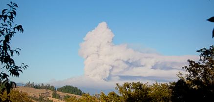
Smokes curls up from the Lassic Fire on August 20. [Photo by Kym Kemp]

Flames could be seen shooting in the air from 20 miles away. [Photo by Julian King.]
Then, we got early access to Lassic’s maps…! We uploaded heat maps from the 20th and 21st together on Google Earth so we could see where the edges of the fire had expanded. (Red lines indicate perimeter.) Then using Google Earth’s measuring tool, we were able to see that one area of a single expansion measured over 1 mile from east to west and almost one mile from north to south. And the fire had swollen in many other areas.

Google Earth measuring tools indicated that one area had grown about 1 1/4 miles from east to west.
To help our readers visualize the incredible progress of this fire, Oliver Cory has prepared two animated maps. The first shows the expansion from August 2nd about midnight until about 9 p.m. last night (August 20th.)

Animation showing the Lassic Fire expanding from August 2 to August 20. [Created by Oliver Cory]

Animation (gif) showing the incredible growth these last four days. [Created by Oliver Cory]

As of 1 a.m., Lassic’s glow no longer dominates Humboldt’s southeastern horizon. The fire appears quiet. With tomorrow’s maps, we’ll find out if that’s true.
Join the discussion! For rules visit: https://kymkemp.com/commenting-rules
Comments system how-to: https://wpdiscuz.com/community/postid/10599/
These are great Cory! Thank you for all the hours you have put in to the fire maps.
These are amaziing ! Thankyou for providing us with such great coverage! It really helps us to understand what these firefighters are up against!
Fantastic job,, Oliver!
Great work on the maps. You should try and make one for harvest time, showing various microclimates finishing and how the harvest spreads out.
Cheers!
Finally…animated maps and they don’t even have to load. Love it.
Zenia, 5:30 pm
Scary looking, isn’t it?