
[UPDATE 9:24 p.m.: Evacuation Warnings Lifted] Trail Fire Grows to 15–20 Acres Near Clearlake Oaks

Trail Fire from Buckingham Camera on ALERT California
A wildfire that began burning about 4:30 p.m. near the intersection of Pomo Road and Elem Road between Clearlake Park and Clearlake Oaks in southern Lake County has grown to an estimated 15 to 20 acres and is spreading at a moderate rate this afternoon, according to the Incident Commander speaking over the radio.
At approximately 5:07 p.m., the incident commander reported the fire, dubbed the Trail Fire, had reached between 15 and 20 acres and was spotting (embers are carried ahead of the main fire and igniting new fires. )The commander asked dispatch to stand by for possible evacuation orders as crews worked to contain the blaze.
The Trail Fire is the largest of three vegetation fires reported in southern Lake County this afternoon. The other two incidents were reported to be making good progress toward containment.
A significant aerial response has been ordered to the Trail Fire.
Scanner traffic indicates CAL FIRE Air Tanker 86 and Air Tanker 133 are assigned to the incident. Both are Grumman S-2T airtankers capable of dropping up to about 1,200 gallons of fire retardant per mission. The aircraft are commonly used for rapid initial attack on emerging wildfires.
Also responding are aircraft identified as CFR 658, CFR 140, and CFR 612. “CFR” designators generally refer to CAL FIRE rotary-wing firefighting resources. Helicopters play a critical role in initial attack operations, delivering water drops, transporting firefighters, and providing aerial reconnaissance and coordination support.
Firefighters on the ground and in the air continue to fight the fire. No structures have been reported lost and no injuries have been reported as of publication time.
UPDATE 5:29 p.m.: Incident Commander says the fire is holding in has slowed down “quite a bit…We’re making good progress.” However, evacuation warnings have been issued. See screenshot of the Genasys Map below for the areas in yellow.
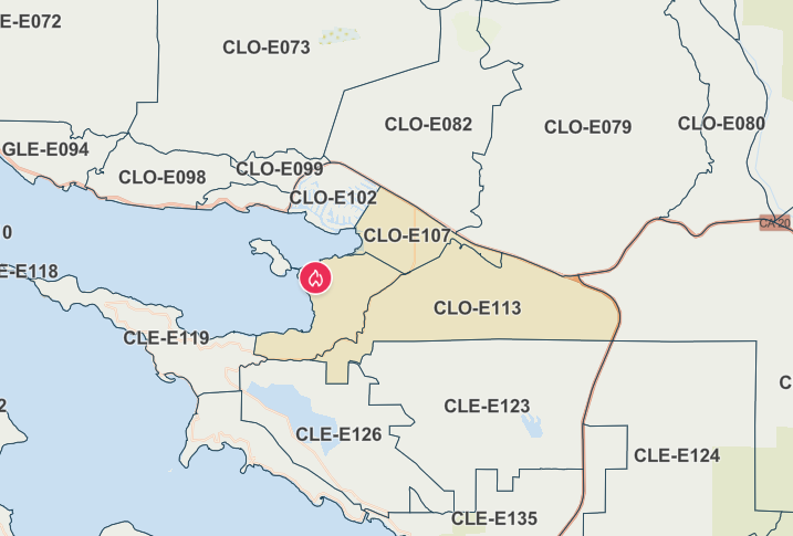
Screenshot of the Genasys Map showing the areas under evacuation warning in yellow.
UPDATE 9:24 p.m.: According to the Genasys, the evacuation warnings have been lifted. Watch Duty reports that the fire is 75% contained.
Join the discussion! For rules visit: https://kymkemp.com/commenting-rules
Comments system how-to: https://wpdiscuz.com/community/postid/10599/
Thanks Cal Fire!
Be safe!