
Roads in the Emerald Counties
Major Highways–Here’s What We Know:
If you are traveling and could take a photo of conditions and send it to us at [email protected], that would help other people make decisions about whether they should travel or not.
At this time, most major roadways are open in Del Norte, Humboldt, Mendocino and Trinity Counties.
(Most information below is from Caltrans’ Quick Map. If you are heading to Oregon, check their similar site.)
-
- Interstate 5: closed from Fawndale to the Oregon Border. ETA on re-opening is unknown at this time. Dependent on weather conditions.
- Hwy 1: Open
- Hwy 3: Open
- Hwy 20: Open but Caltrans message signs warn motorists to carry chains in the mountains east of Clear Lake.
- Hwy 36: Chains Required from 3 miles east of Mad River to Platina. Slide west of Grizzly Creek Redwoods State Park is now open to one way traffic.
- Hwy 36 closed from State Rte 3 east to the Trinity/Shasta County line due to snow
- Hwy 96: Closed 5.5 miles east of Hoopa
-

hoopa
- Hwy 101:Open
- HWY 162: Open
- Hwy 169: Open
- Hwy 199: Open,
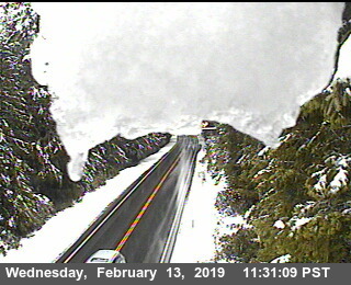
Hwy 199 near the Oregon border. (See Caltrans Traffic Cam for latest image)
- Hwy 211: Open (Check out how high the Eel River is on the Fernbridge live cam)
- Hwy 254 (Avenue of the Giants): Closed Near Holmes Flat Road because of flooding.
- Hwy 255: Open
- Hwy 271: Open
- Hwy 299: Chains required from three miles east of Douglas City to six miles west of Redding.

Snow on Buckhorn Summit. [Image from Caltrans. To see the latest image, click here.]
and CalTrans gives the following general advisory, “Flash flood and flood watch in Mendocino and Humboldt Counties through Thursday 2/14. NEVER drive or walk into floodwaters.”
Humboldt County Roads:
Here is what we know so far:
- Alderpoint Road – Open, carry chains
- Bair Road, between Redwood Valley and Hoopa – open but narrow in spots due to high snow berms, carry chains
- Butler Valley Road – closed due to snow
- Fickle Hill Road PM 5.0 to 5.5–several smaller trees down but passable, crews are en route.
- Ishi Pishi Road at mile marker 1.0–currently closed due to a slide. No estimated time of reopening. Residents can get in from the north end of Ishi Pishi Road.
- Jack Shaw Road – closed due to downed trees
- Kneeland Road, mile marker 26.36 – closed due to downed trees
- Maple Creek Road, from Anderson Ranch to Butler Valley Road – lines tangled in trees, AT&T is notified.
- Mountain View Road – closed due to low hanging wires and trees
- Petrolia, at Lincoln Street and Mattole Road – closed due to downed tree and power lines, you can get around using Front Street but take it slow.
- Shelter Cove Road – open, carry chains
Here is what CalTrans page says about the I-5
[IN THE NORTHERN CALIFORNIA AREA]
IS CLOSED TO NORTHBOUND TRAFFIC 10 MI NORTH OF REDDING /AT FAWNDALE/ (SHASTA CO) – DUE TO SNOW – MOTORISTS ARE ADVISED TO USE AN ALTERNATE ROUTEIS CLOSED TO SOUTHBOUND TRUCKS 26 MI SOUTH OF YREKA /AT EDGEWOOD/ (SISKIYOU CO) – DUE TO SNOW – TRUCKERS ARE ADVISED TO USE AN ALTERNATE ROUTE
CHAINS OR SNOW TIRES ARE REQUIRED FROM 24 MI NORTH OF REDDING TO 19 MI SOUTH OF DUNSMUIR (SHASTA CO)
CHAINS ARE REQUIRED ON ALL VEHICLES EXCEPT 4-WHEEL-DRIVE VEHICLES WITH SNOW TIRES ON ALL 4 WHEELS FROM 3 MI SOUTH OF DUNSMUIR TO 3 MI NORTH OF WEED (SISKIYOU CO) /BLACK BUTTE SUMMIT/
PLEASE RESEARCH CHAIN CONTROL LOCATIONS AS CALTRANS IS CURRENTLY WORKING TO UPDATE CHAIN CONTROL


Join the discussion! For rules visit: https://kymkemp.com/commenting-rules
Comments system how-to: https://wpdiscuz.com/community/postid/10599/
Thank you for the updates, but FYI, it’s “Ishi Pishi”.
fixed it . thanks
Sorry. Caught the first one. Missed the second one.