
An Alliance, a Plan, and the Passion to Restore and Conserve the Large and Intricate Waters of the Eel River

Buck wading in the South Fork of the Eel River. [Photo by Ann Constantino]
The Eel’s watershed which is larger than the Bay Area includes seven sub-watersheds, including an estuary and vast tracts of land under public and private ownership.
There are four phases to the restoration and conservation program, which is currently in Phase One, the planning stage.

Graphics from the presentation.
Part of the planning process will be asking and answering intricate questions about which parts of the river are used by key species at which points in their life cycles, since the needs of juvenile and adult fish within a single species vary widely. The five ‘focal species’ will be chinook, coho, steelhead and rainbow trout, green sturgeon and lamprey. Any restoration efforts will have to take into account the diversity of habitat these species require to complete their life cycles.
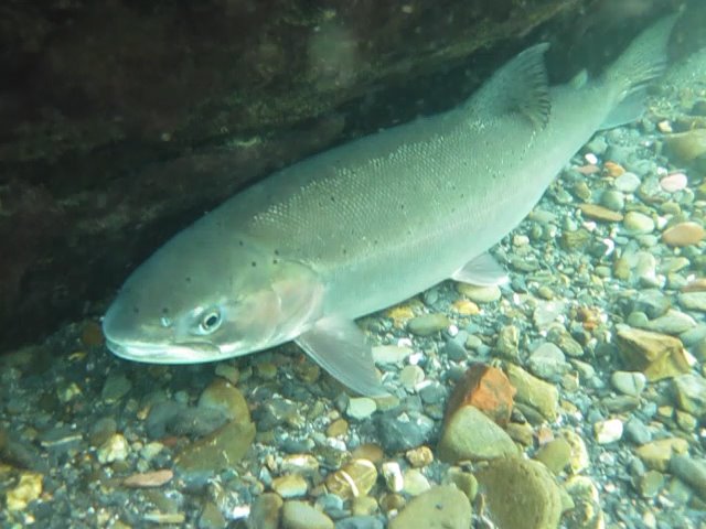
Summer steelhead sheltering in a cold pool on the Middle Fork Eel River. [Photo by California Department of Fish and Wildlife’s Shaun Thompson]
“How do we actually restore life history diversity?” she asked. “We can’t tell a salmon when to smolt and how long to spend in which habitat. But we can work to restore functional habitat diversity. And we know it’s this diversity of habitats that breeds diversity of traits. In this program, we’re considering cool tributaries, coastal mainstems, arid tributaries, and that each of these different habitat types might have played a role in supporting some different tactics through space and time.”
Abel Brumo, a fisheries biologist with Stillwater Sciences, another scientific firm involved in the effort, broke the plan into program goals, sub-goals, and specific objectives, which include removing barriers.

Timeline for restoration and Conservation of the Eel River.
While CalTrout is one of the organizations at the forefront of advocating for the removal of Scott Dam to open hundreds of miles of fish passage, Brumo also tagged culverts and other pieces of smaller infrastructure that have been impairing the health of the river.
Tim Caldwell, another aquatic ecologist with McBain, said prioritization will be the next phase of the program. That will include practical considerations about cost, data gathering, and engaging with landowners along the river to get their support. At this point, the forum has parsed out public and private ownership using GIS data. Only 18.4% of the land in the Eel River watershed is currently protected, according to the standards of the Governor’s 30×30 plan. Caldwell gave a rundown of some possible and ongoing restoration projects in what he called “an ecosystem approach.”

A hungry otter searched the South Fork of the Eel River for food. [Photo by Ann Constantino]
Christine Davis, a project manager and landscape ecologist with CalTrout, tallied up some of the work that has already gone into the planning process. She said the effort has included vegetation health analysis through satellite imagery for the entire watershed, determining how much of the land is in public and private ownership and how much is protected, as well as data on biodiversity.

The Eel River near Bridge Creek Road on the Avenue of the Giants south of Myers Flat at Eagle Point. [Drone photo by Christina Lombardi]
Caldwell cautioned against high expectations when someone asked about the possibility of restoring a harvestable fishery. “I would say we don’t necessarily have an X number of fish that want to come back,” he said. “It’s a restoration and recovery program. We could look back to the historical runs of a million fish. It’s hard to understand if that’s achievable or not in the current state, with not only anthropogenic change, but also climate-driven change. What we’ve talked about internally is looking at trends, and seeing sort of a reversal of existing trends, and moving us towards increasing those numbers rather than trying to hit a specific target as a way to evaluate how the program might be in five, ten, fifteen or twenty years.”
The draft plan for the Eel River Forum’s restoration and conservation program will be ready for review in March of next year.

Mainstem of the Eel River [Photo Credit CalTrout_Mike Weir]


Join the discussion! For rules visit: https://kymkemp.com/commenting-rules
Comments system how-to: https://wpdiscuz.com/community/postid/10599/
Part one of the plan is to demonize and dehumanify and of course in Newsom land to ultimately disenfranchise the private sector farmer and ranchers which big coincidence here they grow the food we all eat. A healthy river is fine but what the goal of the tribal interests is to commercially harvest fish an entirely different thing. I have seen first hand the management of the river fisheries and believe that is in part why the fish runs have collapsed. When the Amazon rain forest is gone California weather models predict 30% less rain fall and the rain that comes will be in more concentrated storms in this situation dams that increases water storage capacity are crucial but instead we vilify, sue, and do everything to make it impossible for companies to properly manage the dam infrastructure we have much less build up the needed capacity.
I am having some trouble understanding your statements. I’ve been under the impression the water in our rain is evaporated from the Pacific Ocean. By what mechanism does the Amazon watershed drive/influence our rainfall. Please just a few references or an argument that lays out how this works. What do you mean when you say “concentrated storms” is that an atmospheric river that is more narrow? It is a fact that warmer air has the ability to carry more water vapor. So it was fine that colonists operated canneries on the Klamath and Eel Rivers?
The equator gets hit with the most sunlight, so it is prone to being a very hot place. Forests cool that potential. Furthermore, as forests diminish anywhere, carbon builds in the atmosphere at a faster rate, driving heating. They have managed to slow the rate of cutting there to 40% of its most extreme under their most previous leader, but it is still pretty scary, and if you look at satellite imaging, there is a ton of fire down there, like Canada.
However the heating happens–deforestation, burning fossil fuels, natural rhythms,– As global heat increases, especially overnight temperatures, the plants in any region draw more heavily on the water table leaving less water in the ground to drain to the surface streams.
Also, as the global air temperature climbs, it changes the flow of the atmosphere. Climate scientists struggle to keep up with understanding how it will impact regional weather patterns.
If you light an incense and watch the smoke waft in a closed room, imagine writing a math problem to predict what precisely will happen to the plume when you heat the room, open the window, add more incense sticks etc. You can predict generally, but what is going to happen in precise corners of the room is more of a struggle.
What they know so far is that the ice has warmed more than the equator, and that loss of difference in temperature between the two extremes has slowed the polar vortex and the jet stream. And they just learned that within the last 5 years. How much the jet stream will slow and how much it will impact our California weather is not yet known. What they predict so far is that the rain and snow will come in larger amounts at a faster rate. Mudslides, debris flows, less water table infiltration. And that the droughts will thus be longer and drier.
Meanwhile, the Atlantic ocean circulation AMOC, which drives the major ocean currents around the entire globe, is slowing down. It might stop.
No one can predict how that will impact things either.
And then sea level rise too.
None of that is intended to suggest the dams should stay in place. They are way too old and were a very bad design when they were built.
As far as flood protection goes, nothing would be as bad as Scott Dam letting go in winter when the reservoir is full.
They received a downgrade on their dam safety rating this Spring as well, down from Satisfactory to Fair.
I do not know how full it was last year when we had those two rollers that took out RioDell, but that damage would be a paper cut compared to the scarring that would occur to the entire channel and then the valley would fill with 12 feet of water–well by then it wouldn’t be water, it would be mud and debris, 12 feet deep.
The diary industry would be shutdown, the creamery would be gone, and how many homes and lives would be taken.
Weather is a little more complicated than the all father sends rain from the ocean and yes the weather models do predict more numerous and more intense atmospheric river storms it also predicts more numerous droughts and this is supported historically in the archeological record of the western United States. It’s not okay for cannerries to overharvest in the distant past.
Like most everything, these are not so simple issues-
“Folks who are in favor of dam removal have been very effective and very vocal in their messaging.” Lynch said. “And I think it needs to be recognized that there is another voice out there. There’s a broader vision for the region, with the benefits of the Potter Valley Project, including Lake Pillsbury.”
https://norcalpublicmedia.org/2022081780728/news-feed/lake-pillsbury-could-be-drained-advocates-see-it-as-indispensable
Well, step one. Dredge the Eel river to a 12′ depth from the mouth to Scotia.
That is the way it used to be. Lumber schooners would come in the Eel River mouth and dock at Port Kenyon. Smaller boats would go upstream to Scotia and beyond.
Exporting gravel would also create jobs… oops… sorry… that’s a no-no.
Just to clarify: Camp Weott was out on the Ferndale Bottoms, not near the present town of Weott. https://www.northcoastjournal.com/091604/cover0916.html
That is an amazing photo of Ferndale Area. Hard to believe.
What’s wrong with our rivers? Mostly the 64 flood. From my understanding, reading and talking to older folks, that’s what I’ve come to.
It may take a few hundred years but the rivers will come back and so will the fish.
A big problem for our rivers is the huge sediment load originally loosened by the glory days of logging, then flushed into the rivers by high water, especially the ’55 and ’64 floods (the Mad was also very badly affected, as seen between 101 and Blue Lake, not to mention the Van Duzen).
You are ignoring the elephant in the room. Pot growers take huge amount out of the river. Blaming logging is a no go since it has long been over. While it is a piece of the puzzle it is NOT the only problem. That fantasy was pushed during the anti logging days along with the spotted owl would only have sex in old growth not second growth timber. The growers have taken a lot of water out of the river along with run off filled with chemicals that include but not limited to poison and fertilizer to feed the weed ie algae blooms. Yes dams are a part of the issue as well. As stated above it is not a simple issue. Taking down dams will release a large amount of sediment that has built up over the years. What do we do.
The part of the release that gets me is they are talking about the land owners cooperation. Sounds like a state power grab to me. You see most people do not realize that on large rivers like the eel it is public/federal land to the high water mark.
Now the Van Duzen used to have barges going up it very far. I believe bridgeville but I could be wrong on that.
As for climate change narrative I am sick of hearing to political BS. Yes it is changing. It changes all the time. Arizona used to be tropical rain forest. Look up the little ice age from 1300 to 1850. Before that was the Medival warm period where it was warmer than now and they grew grapes in jolly old England. Educate yourself people don’t believe every bullshit narrative you hear from the news and special interest groups.
Pot growing had nothing to do with the silting up of the Eel and Van duzen. That happened well before widespread commercial cannabis.
The illicit weed industry rightfully earned ire for overuse of water during severe drought conditions and contributing to the ill health of already ailing river systems from the mid 90s through to today.
Probably the worst contribution of the cannabis boom to our environment was severe forest fragmentation in the post logging regrowth and the intrusion of human noise and light into the forest night.
Those and water use are in severe decline in cannabis. Hopefully we will see a continued improvement in precipitation patterns this winter. And hopefully there will be some thoughtful and watershed scale efforts put in to improve River health in our area. There was not one single cause of the distress they are under, but many many causes throughout the last couple centuries. And their won’t be a simple, single fix either.
Logging is over? I guess you haven’t driven past Scotia lately.
Plus water diversions, pikeminnow, pollution, loss of wetlands…
…. loss of fish hatcheries..
Hatcheries do much more harm than good. https://www.hatchmag.com/articles/50-years-research-overwhelmingly-shows-hatcheries-are/7715778
They’re also incredibly expensive, again, for no real long-term benefit.
There you go again, cherry picking. Humanity is detrimental to wild dogs also. But domesticated dogs seem be doing alright. Hatcheries had great returns. So much so that the wild fish were overwhelmed.
So what do we do? Put all of our eggs in the Wild fish basket until the offshore fisheries drive them into extinction? I think that we should go back to when there were fewer humans. The human hatcheries are overwhelming Earth, and he wild humans are being squeezed out.
I do agree we need to work towards reducing the human population. But, to stay on topic, while hatcheries may provide (very expensive) fish for fishing, they harm the natural ecosystem.
Tucker, have you seen the ecosystem lately. I’ve seen it before and after. Believe me there is NO going back.
I believe that you are good and sincere person, but at some point you might take a step-aside look at the world that we live in. We are not going to fix it. We will have adapt to the current reality. I do believe that we can mitigate some of the damage, but we won’t make it back to the good old days.
I’m in general agreement with you. I’m just not ready to throw in the towel quite yet.
The plan that this article is about represents a very small but, at least regionally, potentially significant step in the right direction.
While our area hasn’t seen much in the way of restoration (and arguably ancient forests are the hardest ecosystem to restore) you ought to get out and see what kind of work true restorationists can accomplish in a decade.
There’s some absolutely amazing work being done with ecologically minded agriculture. I’d point to New Forest Farm in Wisconsin, White Oaks Ranch in Georgia, Coen Farm up in Canada, or get a little more local and check out Paicines Ranch in San Benito County or the White Buffalo Land Trust in Santa Barbara County.
If you want to see some really crazy restoration look at the Al Baidah project in Saudi Arabia.
Humans are the only species on earth capable of rapidly restoring the ecological paradise we destroyed
And the flood…was as much a result of intense logging after WWII as it was of a big storm. You would not have seen all that gravel without miles & miles of denuded watershed
I have been in high wilderness areas in this area in virgin country both before and after the1964 flood and observed tremendous erosion in tributary streams close to their headwaters after the flood. So this was a really big event not all attributable to logging.
How old are you? To have been in “virgin country” out here you must be quite advanced in age!
I have pictures of virgin National Forest hillside that have felt nothing but the pitter patter of moccasins. Whole watersheds slipped into the river from the rainfall.
Most of you have never heard of the Columbus Day Windstorm of October 12, 1962. With due respect to the Indigens for using the word Columbus.
The storm blew down millions and millions of board feet of timber, tan oak, madrone, maple, you name it, it blew down. Redwood forests looked like tooth-picks standing on end. The wind stripped their limbs off. We just past the 60th anniversary last year. I was shocked that it didn’t even make the news.
The trees, of course, blew into the canyons and clogged the creeks. They were salvage logging and pulling timber out of the creeks when the storm flood of 1964 hit.
But, all the armchair scientists blamed the high tide, the loggers and hastily build skid roads for the flood. Just to put it into context for the current residents of the Eel. There were good loggers and there were carpet bagger opportunist loggers. The same as he weed industry. Some of your houses have blow-down timber in them. You should be ashamed of yourselves.
But, hey, it’s been fun talking to folks that know it all, but have seen nothing, that still have their fingers in their ears singing la, la, la. Present company excepted, of course. But, if the shoe fits try it on.
You really are naive, aren’t you.
I used to permit gravel extraction for HRC. We could take 100,000 yards/year and we did for local use. When the train was running to the Bay Area they’d export it. After the train stopped running the economics of shipping it on a barge or by truck don’t pencil. We tried and tried because there are hungry buyers for gravel down there but by the time you truck it from Scotia to our bay you’re never gonna make any money putting it on a boat.
The cynic in me suspects that the plan is for these folks to siphon off huge chunks of public money to produce small results. I hope I’m wrong.
I just can’t see how all the requirements of a Progressive agenda of free and uncontrolled immigration, providing adequate food, water, health care and housing to all, while guaranteeing absolute equity in doing it, yet limiting capital investment and acquisition, still can avoid taking resources away to do it. I always have the feeling they believe in the unlimited efficacy of money, seeing it as never ending, more than most people.
I don’t think the majority of the people involved in this coalition would qualify as “progressives”. So I’m not sure how this relates to a “progressive agenda”.
This seems to be a coalition of people working to restore a tremendous river system to some semblance of health. Environmentalism is much older and supported by a much wider base than the sort of modern progressive politics you’re describing
This comment actually made me think further. I conflated people who are unwilling to deal with realities to the point of absurdity with Progressives. It’s true that people who want to return to some golden age are not automatically Progressives. The only thing that made me think so was the shared willingness to dismiss reality and responsibility in service to ideology. Which both these groups share.
People who want to return the Eel to even a semblance of undisturbed nature have to determinedly ignore the presence of whole communities and livelihoods that came into existence based on having the resource. With the likelihood too of it not being the result if they succeed because nothing is what it was and frankly never was undisturbed since the arrival of men 20,000 years ago.
Same as Progressive have a belief that humans have some sort of innate natural innocence that would create a golden age if not abused. Still, while not forming identical groups, that peculiarly of thinking is at least likely to cause create a happy commonality between both. At least at the planning stage.
Your comment reads like you’re mostly thinking about how you can bash this article and “progressives” in the same comment. It doesn’t rear at all like a response to this actual article or the plan as it is outlined therein.
No where does anyone mention returning to any “semblance of undisturbed nature”. Everyone quoted and all graphics share indicate that the goal is to find workable solutions, within the watershed as it exists today, to support improved health for 5 identified species. And those species population health seems to be being used as a metric for river health.
The whole thing sounds remarkably pragmatically approached for such a wide scope objective. So what is your actual critique of the plan as proposed?
You’re absolutely wrong. I’m part of this team and have never worked with a more capable and dedicated group of scientists.
Does everyone on your team refer to the public as chumps, or is that limited to the person who most often represents you publicly?
(See Scott Greacen’s comment below.)
The entire purpose of this meeting – the Eel River Forum – is to bring this information to the Public, recognizing the importance of public input to our Planning process. I think our actions and thorough presentation materials speak for themselves.
You mean they got rid of 99% of the grows and the river is the same? Go figure
I am available to hire as a consultant.
At least some of the “study money” would be spent locally. I practically lived in the South Fork Eel river before the 1955 and the 1964 flood. The river was much different than is imagined. But, since I have become woke, the first thing we would have to do is change the name of the “watershed” to the Conger River. As everyone knows the locals were ignorant and named everything wrong.
The 1860-61 flood was worse than the last great floods that we have experienced in 1955 and 1964. Before 1955 the river banks were lined with willows, so much so that the air was ripe with the sweet smell of willow bush in the summer heat. The weather was scorching hot, like the weather is currently in the summer. There were great numbers of Chert and Jasper rocks like the Old Timers built their fireplaces from. The softer rocks like sandstone and mud rocks most had washed on downstream in the hundred years since the last “thousand year flood” because those rocks are lighter.
The river holes were scoured out and very deep. There was a whirlpool hole under the bridge to the airport in Garberville that was reported to have been 60 feet deep. I don’t know, I was not able to dive to the bottom of it. The holes that I was able to dive to the bottom of had silty bottoms. You had to prove that you got to the bottom by bringing up a hand full of bottom muck.
The riffles were gravelly and the river banks were sandy and filled with baby Eels. (sp. sorry) There were baby toads everywhere. The toads migrated inland at the first big rain.
I am greatly encouraged to see that the river is showing good progress in healing the flood damage. Just in time for me to take credit in “saving it” if I am hired.
P.S. I work cheap…
Not only the fish were different before the floods and other catastrophes. The aquatic plants were almost completely different.
If we restored the the rivers and streams to perfect fish habitat we would only send them into a depleted ocean for other Pacific counties to catch. And they don’t play by our rules.
It makes a lot of sense to have fish hatcheries and fish farms. That way the fish could be controlled. We could sell them to other counties instead of us buying the fish that we spawn in our rivers for them the catch and sell to us.
Capisce? Rhimes with Feesh.
Way to drop the diversity bombs ?
But it’s science! Crack me up
You reactionary chumps crack me up.
R.E.M. had y’all pegged back in 1987 – “Offer me solutions/ Offer me alternatives/ And I decline”
As always, there are none so blind as those who refuse to see.
The White Queen saying “Why, sometimes I’ve believed as many as six impossible things before breakfast. . . . ” was not a recommendation for political action.
Some of us see more than you think Scott. We see that you have made a good career of environmentalism.
You learned out of books. I learned with my toe in the water. Not is all what you think. Hey, I offered to work cheap.
Scotts website. https://www.climateone.org/people/scott-greacen#:~:text=As%20the%20Executive%20Director%20of,%2C%20its%20fisheries%2C%20and%20communities.
And here is how you can donate to him, You can even donate anonymously. https://commonwealthclub.my.salesforce-sites.com/donate/?dfId=a0n3j00000sNND2AAO&
Scott’s trying, Ernie. He recently listened very carefully to my experiences and welcomed a virtual treatise of both written and oral historical information I shared with him and his erudite associate Alicia about the river. He was actually amazed. It’s sad that government remedies are so generally ineffective and how local knowledge is discounted in making decisions and how difficult it is to move forward thru our metropolitan oriented bureaucracies, particularly in California, where we live in name only.
Thank-you Jeff. I am often amazed with what people don’t know about the Eel canyon. If a picture is worth a thousand words, being there is worth a thousand pictures. Thank you for being there.
FYI.

I saw it first hand in the Marble mountains.
Some of the information I gave Scott pertained to the past hatchery success in this area. Steelhead creek, Cummins, Price Creek, Mad River , massive plants from Sacramento river and McCloud river hatcheries,local rearing ponds. This included Humboldt Bay. Once fish are extinct in certain tributaries, they just dont repopulate very well absent hatchery reintroduction. Look at Southern Oregon rivers. Chetco,Rogue, Elk, Sixes and Coos all rely on hatchery fish and have great runs of hatchery fish. And lots of fishermen. Season on there! Almost all Sacramento and Klamath fish are of hatchery origin. Why not the Eel. All that has been stopped. Indeed, the Mad river hatchery was originally seeded with Eel fish. Now it runs at a fraction of its capacity with no plantings in our rivers except there.
I belonged to the Garberville Rotary Club. Back in the 80’s 90’s? we raised steelhead in the various South Fork Eel tributaries. We had tremendous success. Fish and game made us quit. They said that our steelhead were eating salmon fry. Among other reasons.
Except during that time there were plenty of Salmon. The Salmon and steelhead runs went down after the squawfish invasion. How the DFW missed that doesn’t surprise me though. Even the suckers and lamprey population plummeted after that. And still twenty five years later no squawfish eradication efforts.
Is calling others chumps good public relations for your organization?
Ernie hit the nail on the head.
It’s hard to believe the Eel River once had an annual run of a million adult salmon. Unfortunately, conservation’s been a hard sell. One stick of dynamite or jab with a pitchfork, in a riffle full of fish, would feed a family for days.
Being that we all believe in studies science and research. Here is a tidbit of scientific research. The carrying capacity for human beings on Earth. I’m going for the 4 billion study.
This is my home. I want it to be healthy and thriving. We have hundreds of miles of swimming holes, secret fishing runs and far fetched, rarely visited streams. The Eel is awesome. I enjoy the pulse of rivers after floods (55 and 64 and 97 and 83 and…) and seeing them recover. We live in a truly awesome watershed.
Stop the steal!!
Return the waters to the Eel!!!