
[UPDATE ] New Fire Near Shasta Lake Growing Fast

Smoke boiling up from the Hidden Fire near Shasta Lake. [Image from Alert California]
Evacuation Orders and Warnings
According to the Shasta County Sheriff, an evacuation order has been issued for zones JVA-4280 and JVA-4290. This includes the areas:
- North of Hidden Valley Drive
- South of Sunshine Way
- East of Bear Mountain Road
- West of Marin Drive and Backbone Road
- North of Ravine Road
- South of Hidden Valley Drive
- East of Bollibokka Way
- West of Marin Drive and Ravine Court
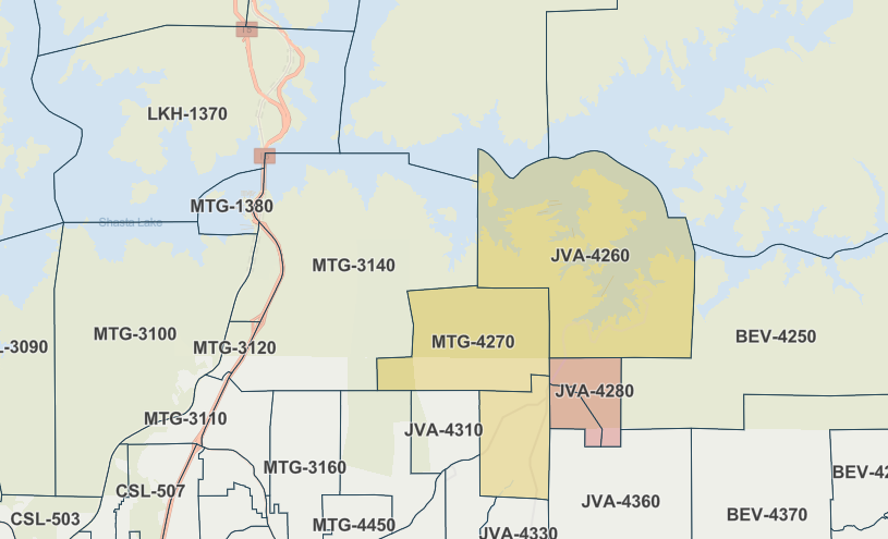
An evacuation warning is in place for zones MTG-4270 and JVA-4300. Residents in these areas are urged to be prepared to evacuate if conditions worsen. The most recent information can be found on the evacuation zone map.
Fire Progression and Response
By 4:50 p.m., the fire had already spread to an estimated 20-30 acres, according to radio reports. The situation escalated quickly, and by 5:00 p.m., the fire had grown to 40 acres with a moderate rate of spread, affecting both grasslands and timber. The fire had also crossed Dry Creek Road, moving towards Shasta Lake. The potential spread is estimated to reach up to 200 acres.
In response to the growing threat, air attack units have requested two additional tankers, bringing the total to four. Ground units have been mobilized, with an immediate request for five more engines, a strike team comprising five additional engines, and two more dozers.
Road closures have been implemented at Highway 299 and Dry Creek Road, as well as Bear Mountain Road and Dry Creek Road. A temporary collection site for evacuees is being established at Bella Vista School.
UPDATE 6:17 p.m.: New evacuation orders have been issued. Below is the newest map.
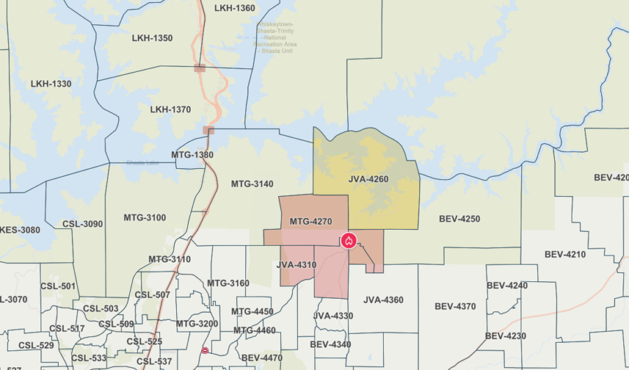
New evacuation orders. The most recent information can be found on the evacuation zone map.
UPDATE 7:26 p.m.: Cal Fire is reporting, “#HiddenFire near Bear Mountain Rd, Redding in Shasta County is 100 acres.”
UPDATE 8:54 p.m.: Cal Fire has issued a new estimate, “#HiddenFire near Bear Mountain Rd, Redding in Shasta County is 45 acres and 25% contained.”
Join the discussion! For rules visit: https://kymkemp.com/commenting-rules
Comments system how-to: https://wpdiscuz.com/community/postid/10599/
Fires are breaking out all over the State.
Yup. Gusty winds, should die down on Tuesday (or so).
Freeze warnings out on June 16. It is snowing in the North Rocky mountains.
Praying for all in this areas and that they can get up it out fast!
Power lines? What’s the cause?
Global warming. You didn’t know?
Jewish space lasers, says MTG.
There is a scared little brendal bulldog with a blue harness on ravine rd. He’s hanging out on our porch
Please secure this frightened baby. Tomorrow you can take him to any vet or Haven Humane to be scanned for a chip. If you cannot do that, then please contact animal control to pick him up.
These maps are useless to the public . Cal fire needs to overlay some details
the evac maps are extremely helpful.
Educate yourself. What evac zone do you live in? Learn that and then its very useful.
Except for your name… yeah its likely way to hard for you to figure out.
Sorry.
Please everyone be safe and move if asked to by Cal Fire. Your life may hang in the balance. Head to Bella Vista School. Take your dogs and cats so they don’t perish in a fire.
I for one would appreciate better maps with specific details. The Cal Fire maps are for their use basically.
No the CAL FIRE Evac Zone maps And Fire Incident location maps have specific details and Are very easy to read and underdtand. But not if you are from an area far far away.
I guarantee the actual locals find it very easy to read and understand. Why is this hard.
Good luck.
I8