
[UPDATE 3:36 p.m.] Red Flag Warning Over the South Fork Complex Mostly Burning in Humboldt County But Threatening Hyampom in Trinity County
 A series of wildfires, collectively known as the South Fork Complex, are currently posing a threat to the small community of Hyampom in Trinity County. The fires, which mostly originated in Humboldt County, appeared in the wake of thousands of lightning strikes across northwestern California in the early part of this week.
Comprising four distinct fires – the 3-9, Pilot, Sulphur, and Pellitreau – the South Fork Complex has shown serious growth since its first ignition. Occasionally, part of the complex is referred to as the Bennett Fire but, Six Rivers National Forest Service does not use that designation. The blazes so far have consumed a total of 912 acres–that’s a jump of nearly 400 acres—with none of it contained, according to information provided by the Northern California Geographic Coordination Center. The 3-9 is 412 acres, Sulpher is 33 acres, Pellitreau is 3 acres, and the big one is the Pilot which is 464 acres). Active fire behavior continues to be observed, further complicating firefighting efforts.
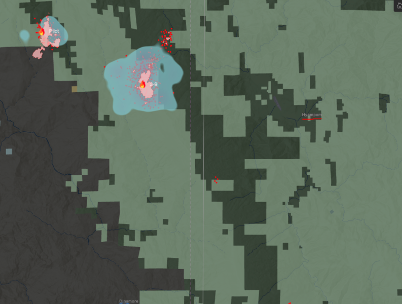
South Fork Complex with Hyampom underlined in red. The Pilot Fire is marked as such in the upper left of the image. The 3-9 Fire is marked and is the fire to the lower right of the Pilot Fire. Pellitreau Ridge is roughly where the four red dots are in the center of the image above. We believe but don’t know that is where the Pellitreau Fire is located. The Sulpher Fire is slightly below the area shown in the middle right of the image above, (there is a part of a single red dot there) but again that is not official.
Occasionally called the Bennett Fire, one of the fires within the complex nearest Hyampom is now the 3-9 Fire according to the Six Rivers National Forest Service. The exact cause of the fires remains under investigation, although it has been confirmed that they ignited following a series of lightning storms that swept across the region on Monday and Tuesday.
Weather: The National Weather Service in Eureka has issued a Red Flag Warning for the Hyampom area from 1 p.m. to 8 p.m. alerting the community that there could be “abundant lightning on dry fuels.”
Scattered to isolated thunderstorms are expected again this afternoon over the interior. Stronger south and southeast flow aloft will support faster storm motions today and increase the potential of dry strikes and gusty outflow winds outside the main precipitation core. pic.twitter.com/Dy7LxEym4W
— NWS Eureka (@NWSEureka) August 19, 2023
Other Important Information:
The urgency of the situation is evident as the fires encroach upon the community of Hyampom and its surroundings. The National Weather Service in Eureka issued a Red Flag Warning for the Hyampom area, indicating a high risk of “abundant lightning on dry fuels.” This ominous forecast should prompt residents of the area to remain on high alert and follow evacuation orders if they become necessary.
The South Fork Complex’s spread also threatens critical infrastructure in the region. The fires are now approaching high-pressure gas lines, power infrastructure, and private timber lands. Additionally, the complex has the potential to impact the crucial watershed for the Mad River area with potential long-term ecological consequences.
As the firefighting efforts intensify, California Type 2 Incident Management Team 11, under the leadership of IMT Commander Fogle, assumed command of the situation as of 8:00 a.m. today.
Residents in the area are urged to stay informed through official channels, adhere to evacuation orders (if any are issued) and warnings, and prioritize their safety and that of their loved ones.
Also of interest, the Lookout’s view of the fires:
- Command: Ca-Type 2, IMT 11
- Evacuations: There are evacuation warnings in the Hyampom area. For the most up-to-date information on evacuations in Humboldt County use the evacuation map at https://protect.genasys.com/search. For the most up-to-date information on evacuations in Trinity County go to https://tinyurl.com/29f8uwmk
- Important links to also watch:
MAPS:


UPDATE 3:36 p.m.: Press release from the Shasta Trinity National Forest:
:
Earlier:
-
- Red Flag Warning Issued as Lightning Strikes Pepper the Emerald Triangle
- Powerful Lightning Storm Leaves Multiple Fires to Combat in Northwestern California
- Lightning-Sparked Wildfires Stretch Resources in Northwestern California; Head Fire in Siskiyou County Estimated Over 3000 Acres
- Wildfires Unleashed on Northwestern California: Thousands of Acres Covered by Flames, Evacuations Ordered Following Lightning Storms
Join the discussion! For rules visit: https://kymkemp.com/commenting-rules
Comments system how-to: https://wpdiscuz.com/community/postid/10599/
So with fire fighting resources spread out over so many fires; it is a good idea to postpone activities like mowing, chainsaw and line trimming to avoid any accidental fire starts to add to the mayhem.
Excellent advice.
Getting thunder and lightning now in Trinity county, Plummer Peak and Horse Ridge are reporting down strikes south side of Dubakella Mountain
Thanks for that info Grumpy, it is appreciated!
Here is a cell popping up east of Redway
Thunder just starting to be audible on Pratt Mountain. 8/19/23 @ 2:20 PM.
3:10 I’m in Laytonville. BIG clouds and thunder just East of here.
I moved to indoor work.
Thanks for the heads up.
Spotter and helicopter just headed that way, South SouthEast
It’s been hitting here for a couple of hours.
I’m sitting out in it like a kid in a candy store… It’s hard sitting still bit I figure I will cover my area.
Stiff, warm variable wind right now @4:30PM…
Not good, if there are any more ignitions.
Neafus Peak has been getting hammered, but I don’t see any smoke yet.
Stay safe Ernie.
If it gets bad here I will send you some smoke signals?.
Good luck up there! The storm the other day was intense! We caught close to 500 gallons of rain within 15 mins. I watched that fire on Pratt start the other day. Smoke came up from the woods within minutes of the strike. I called it in right away.
Thank you.
Fire at Kinsey Ranch.
Unconfirmed report of fire near Alderpoint VFD Station.
Getting big thunder here in potter by the eel river
I’m northwest of you, thanks for the heads up. That was a great early warning!…
Been going off here for a good 2 hours. @4:30 PM
Helicopter and spotter just boogied South SouthEast out of sight towards you…
My eyes are glued on this site right about now:
https://www.lightningmaps.org/#
Thanks for the link! Watching it now too. Looks like Orleans is getting hit hard.
I live in orick and I’m a little nervous to say the least.
Zonehaven says that the status in the zone of those fires (E114) is normal and there aren’t any warnings of any kind. Could be another Lahaina in the making… a clear and vivid threat, no warnings.
I am six miles west of the fire right now and can hear thunder to the east.
Please everyone in and around these fire zones stay alert and monitor what is happening constantly. If you are asked to leave immediately, get the hell out. Nothing is worth saving that may cause you to lose your life!
Can’t be much fuel left over there right? At least on the west and north sides of south fork? I know pellitreu has fuel though.