
Firefighters Battle Lightning Complex in Humboldt County

Pearch Fire view from Orleans looking east. [Photo from InciWeb]
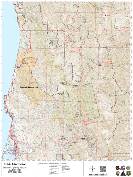
California Incident Management Team 2 is in command of the Six Rivers National Forest (SRF) 2023 Lightning Complex and Redwood Lightning Complex, which includes the following 12 fires. Total estimated acreage for the SRF Lightning Complex and Redwood Lightning Complex is 5,441.2 acres with 15% containment.
Redwood National and State Parks Area
Lost – Full suppression tactics continue on the Lost Fire, estimated at 529 acres on Redwood National and State Parks lands. The fire is located northeast of Orick in the Lost Man Creek watershed west of Holter Ridge Road and south of the Lost Man Creek Trail/Geneva Road. Crews are working to prevent the fire from entering old growth forest and have held the fire on Holter Ridge. Other fires in the area have been contained. CAL FIRE and Green Diamond Resource Company are collaborating with suppression efforts on the Lost Fire.Devil – 12 acres contained and in patrol status. Glenn – .1 acre contained and in patrol status.
Hoopa Area
Lone Pine – Located south of Hoopa in the Horse Linto Creek watershed east of the Trinity River and across the river from Tish Tang Campground and Sugar Bowl Ranch, fire size is estimated at 1,678 acres. Crews are constructing dozer lines and hand lines for containment. The fire is smoldering with minimal growth. Crews are continuing with mop up activities.Orleans Area
Pearch – East of Orleans is estimated at 981 acres with a slow rate of spread. The Orleans pumphouse has been prepped with structure wrap. Structure protection personnel are continuing to prepare homes and structures around Orleans and have made significant progress. Hose line and sprinklers have been placed around values at risk.Pearch Fire Evacuation Warning:
Orleans
Zone HUM-E009 (Southeast of the Klamath River in Orleans)
Zone HUM-E008-B (Community of Orleans, west of Klamath River. East of Crawford Creek, including Orleans proper). Hwy 96 and Red Cap Road along the east bank of Klamath River, south from Salmon River, east to Orleans Mountain. Approximately 243 residents live in these 2 zones.Somes Bar
Zone SIS-1701: NORTH of Monte Creek Road, SOUTH OF Camp Three Road, EAST OF Camp Three Road, WEST OF Wooley Creek Trailhead. Anyone in these areas should be prepared for potential evacuations, including personal supplies and overnight accommodations. Be ready to go at a moment’s notice.Iron – Located above Ti-Bar Wildland Fire Station with minimal fire activity.
Hancock – Located in the Wooley Creek area within the Marble Mountain Wilderness, staffed by a crew of ten smoke jumpers. Personnel are engaged in point protection efforts to protect values at risk.
Mosquito – Near the Bluff Creek area north of Mosquito Lake is estimated at 1,061 acres. The fire remains north of Forest Road 11N19 and west of Forest Road 12N12 (Cedar Camp Road).
Containment lines along the 12N12 road have held. Crews continue to construct containment lines.Bluff #1 – 828 acres with minimal movement.
Let er-Buck – 34 acres
Blue Creek – .1 acre Blue Creek 2 – 318 acres. The Blue Creek and Blue Creek 2 are currently unstaffed due to limited resources. Additional resources are on order.
Weather – High pressure will build over the area causing temperatures to rise and humidity to fall. Onshore westerly winds return in the afternoon with gusts up to 18 mph, potentially up to 20 mph in certain areas. The weather change has potential for larger fire growth.
Six Rivers National Forest Closures
Area and campground closures are in effect on Six Rivers National Forest. They may be found at: www.fs.usda.gov/detail/srnf/notices/?cid=FSEPRD1096395.Redwood National Park and State Parks Closures
Due to fire activity in the area, Lost Man Trail from the trailhead on Bald Hills Road to the gate at the Lost Man Picnic Area is closed. Lost Man Road will remain open from Hwy 101 to the Lost Man Picnic Area. www.nps.gov/redw/planyourvisit/conditions.htm
We’ve gathered the most important information about the Six Rivers Lightning Complex Fire and organized it below for our readers.
The Plan:
The Roads:
There are no major road closures in the areas of the fires.
The Map:
Information to know:
- Command: California Incident Management Team 2
- Evacuations: 𝗘𝗩𝗔𝗖𝗨𝗔𝗧𝗜𝗢𝗡 𝗪𝗔𝗥𝗡𝗜𝗡𝗚𝗦 𝗿𝗲𝗺𝗮𝗶𝗻 𝗶𝗻 𝗲𝗳𝗳𝗲𝗰𝘁 𝗳𝗼𝗿 𝗛𝘂𝗺𝗯𝗼𝗹𝗱𝘁 𝗖𝗼𝘂𝗻𝘁𝘆 𝘇𝗼𝗻𝗲𝘀 𝗛𝗨𝗠-𝗘𝟬𝟬𝟴-𝗕 𝗮𝗻𝗱 𝗛𝗨𝗠-𝗘𝟬𝟬𝟵 𝗱𝘂𝗲 𝘁𝗼 𝘁𝗵𝗲 𝗣𝗲𝗮𝗿𝗰𝗵 𝗙𝗶𝗿𝗲.For the most up-to-date information on evacuations use the evacuation map at https://protect.genasys.com/search
- Important links to also watch:
Earlier:
- Red Flag Warning Issued as Lightning Strikes Pepper the Emerald Triangle
- Powerful Lightning Storm Leaves Multiple Fires to Combat in Northwestern California
- Lightning-Sparked Wildfires Stretch Resources in Northwestern California; Head Fire in Siskiyou County Estimated Over 3000 Acres
- Wildfires Unleashed on Northwestern California: Thousands of Acres Covered by Flames, Evacuations Ordered Following Lightning Storms
- Lost Fire Near Orick Continues to Blaze Uncontained and Unnoticed in the Midst of Wildfire Overload
- Wildfires from Orleans to Orick to Hoopa United Under New Name and One Command
- From Hoopa to Siskiyou and Over to Orick–the Six Rivers 2023 Lightning Fires Current Situation
Join the discussion! For rules visit: https://kymkemp.com/commenting-rules
Comments system how-to: https://wpdiscuz.com/community/postid/10599/