
[UPDATE 9:10 p.m.] 100 Acre Wildfire Burning in the Usal Area of Northern Mendocino
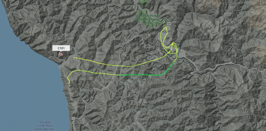
Copter 102 on Flight Radar over the Usal Fire. From flight patterns of the aircraft over the fire, the fire appears to be surrounding the camping area.
A 100 acre fire is burning in the Usal area, confirmed a Cal Fire spokesperson this morning. More recent scanner traffic indicates it is over 130 acres.
Last night, campers fled the area up the one-lane dirt road as firetrucks attempted to respond driving into the area. According to MendocinoSportsPlus, a Facebook-based news source, who was listening on the scanner about 11:45 last night, “First responders had a hard time accessing the site because a lot of vehicles were leaving the beach on the narrow access road.”
According to traffic over the scanner, there are two helicopters, 101 and 102, at the scene as well as tanker 96. There are multiple ground crews as well.
UPDATE 10:40 a.m.: According to Cal Fire’s Scott McLean. Deputy Chief of Communications, the 130 acre fire is burning near the Usal campground. The first report came at 11:36 p.m. yesterday. There is 0% containment.
The fire is only spreading slowly in heavy timber and slash, McLean explained. However, he added, “Because of the fuel density, it takes a lot of resources to extinguish something like this.“
UPDATE 10:47 a.m.: Cal Fire tweeted that campers are “Sheltering in place at Usal Campground. Usal Road closed.”
UPDATE 11:06 a.m.: We haven’t been able to learn if the famous candelabra redwoods along the Peter Douglas Trail are in danger from the fire.
UPDATE 3:47 p.m.:: Cal Fire tweeted that the fire is now 30% contained and still 130 acres.
UPDATE 7:20 p.m.: According to Trisha Austin, spokesperson for Mendocino Cal Fire, the majority of the campers have been allowed to leave. “Anyone with 4-wheel drive can leave,” Austin explained. She explained though that some campers are still sheltering in place. “I don’t have a count of how many remained,” she said.
She hopes to have an update on the size of the fire and containment soon after 8 p.m.
UPDATE 9:10 p.m.: We’ll have to wait until the morning for size and containment update. Here are the stats on those assigned to the fire, according to Mendocino Cal Fire:
Resources Assigned: 6 Crews, 10 Engines, 4 Dozers, 6 Water Tenders, 2 Other Equipment, 10 Overhead, 3 Helicopters for a total of 216 Personnel.
Fire resources will remain on scene overnight to continue heavy mop up and strengthen control lines in the steep, rugged terrain.
Cooperating Agencies: Mendocino County Sheriff’s Department, California State Parks, Save the Redwoods League, California Department of Corrections and Rehabilitation and Mendocino County Fire Services.
Join the discussion! For rules visit: https://kymkemp.com/commenting-rules
Comments system how-to: https://wpdiscuz.com/community/postid/10599/
Isn’t the road to Usal off highway 1 heading to the coast from Leggett?
Correct. Usal Road is the old Route 1, now a 1-lane dirt road heading north from Hwy.1 into the Sinkyone Wilderness State Park.
Was never Rt 1, it was a logging road, but you are correct in that it is kind of a natural extension of Rt 1 between the coast and Shelter Cove.
Yes
Yes Mona. You take a right from Highway 1 heading north up to the Usal compground if you’re coming to the coast from Leggett.
Caltrans took down the Usal road sign several years ago. Locals spray painted “Usal Road” with an arrow on the Hi 1 pavement. It is near the Cottoneva Bridge.
Yes it is lots of Rosevelt elk out there as well
Any word as to the cause? Heavy timber and slash sounds like industrial land rather than park. There are really important areas there, not just the incredible beauty of Usal and the unique Candelabra trees, but tribal lands there owned by ITSWC. Those lands are all high priority for protection.
Yeah that’s were I live now me and the rest of the heard are really worried that we will lose are home it’s all we got out here sheesh! I hope they get this one out fast.
Leading a large group of dual sport motorcycle riders for our annual Lost Coast trip end of August. We always stay at Usal beach. Has anyone travelled Usal rd. (The section from Shelter Cove side) trying to find out rd conditions
Thanks
I hope they get it out fast for the elk and for all the people firefighters be careful
I just got home from there. Had to take back roads out. You have to have 4×4 to get out. People are trapped on the beach right now. It started around 12am last night. I believe someone didn’t put their fire out on the beach. Then it ran up the cliffs.
Please consider contacting me at [email protected]
There is also a private access road from behind, West, of Richardson Grove to Usal/ Sinkyone Wilderness State Park, its how State Parks gets out there for trash p/u, maintenance and collects camping fees…
I am surprised that CalFire doesn’t have a key to the M&M road gate. The M&M road is a two lane road that ends near Usal Beach.I have traveled 1hat road 100’s if 1000’s of times when I was logging there.
The M&M road is built for moving heavy equipment unlike the Usal road.
All the land surrounding Usal beach has been heavily logged over the last 150 years or so.
I’m a ptrolman for that property at various times of the year and its a nice road until you get to the creek. It’s a big mudpit as a month ago but may have dried a little. Pretty sure the fire is on part of that road now close to the campground.
It is a combination lock , which local fire has and also cal fire, I think
.
Yes they did they open the M&M rd for ppl to leave !! There were fireworks also that night so it may be the reason this fire started !
Oh no! Where are all the hippies and rednecks going to throw their used whippit canisters and shoot fireworks now?!
hi , saw you over on the dyerville bar , eel river , 1985 ? remember me ? you seemed to be looking in the water for something ? fish ? i guess cryptozoological legends have to eat too ? ciao …
usal beach cannot burn , its sand , i have camped there many times , though not lately , the surrounding forest looked pretty moist ? remember watching some folks dip netting for candlefish there , they gave me some , i froze them in a block of ice , little eyes looking out at me — the usal road turnoff used to be well marked on highway 1 , spray paint ..
The beach may not burn but the amount of smoke I saw at the beach the minute the hill was burning will suffocate anybody ! It was terrifying to watch and experience this
Usal Beach/creek campground was a nice place once. It has been destroyed by disrespectful people, off-roading through the Creek, leaving trash strewn all over, and terrorizing wildlife.
That a fire started there now is a direct result of the total lack of any management or care by CA state parks, an agency that purports to manage the place. Actually total neglect.
RFFI, some kind of non profit was supposed to help, maybe fix some roads and offer a seasonal campground host. That never happened.
Based on my last visit, this is a lawless and dangerous place, especially on weekends like now when people have excess fireworks and alcohol. Never a good mix, especially in a remote wilderness setting.
CA State Parks should be taken to task over their mismanagement of Usal Beach and Sally Bell Grove, not to mention their total paralysis when it comes to the Sinkyone Wilderness. These lands should just be transferred to BLM for management with the King Range. At least BLM dedicates some staff time for actually managing their lands, unlike State Parks which pretty much sits on their hands in offices in Eureka or Sacramento.
Maybe the Bundy family is available for squatting and protecting everybody’s rights there.
I believe RFFI wants to build a highway(improve the road) in there so everyone can enjoy it.. puff puff
The state is spending all the cash on migrants an railroads to nowhere, and now wants to turn the NWP into a dirt trail. That is progress. Humboldt an surrounding counties could really use that RR.
listen to gramps — in the olde days we DID have the railroad , but the 1964 floods , unstable plate tectonic geography , put an end to it — now it would cost BILLIONS of rubles to repair it .. too bad ..
blah , blah , blah — I moved to Humboldt county in 1971 — used to be real nice before all the logging and pot growers — usal beach was an empty wilderness — nobody there — if we camped there , its was like backpacking , leave only footprints , take only pictures — too bad you ruined my county — thanks again ..
Ive lived in the Eel river canyon for over 70 yrs. after the 63 64 flood the NWP was still a viable RR. and the billions of dollars were well spent! providing year round jobs. you just don’t understand how a RR works, the original RR where the load started gets 80% of the cost to take that load to Pine Bluff or New York. The California western made good money on lumber transportation. All the little short lines north of the NWP did also, as long as there was timber to haul. We are in short supply of public transportation in Norcal, not to mention that a ride on the NWP up the canyon is really a beautiful ride, with a lot of wildlife to see. There are still plenty of sawmills an wood processing places along the NWP, from Cloverdale north, plus winerys . All you johnny come latelys don’t have a clue.
I have a son at the Redwood Adventure Camp on Hermitage Road. Should I be concerned?
No, it is miles away.
@hooktender It’s my understanding that a seasonal bridge on M&M Road is not installed yet. Also, if CalFire was responding from Fort Bragg or Mendocino, Usal Road is the quicker route.
That is correct. You can’t get across to the M&M road at the moment. No bridge across Usal Creek. And the crossing there is only proposed as temporary during loggin operations…
They did opened the M&M road on Sunday around 10ish am for ppl to leave. I got evacuated through that road
Usal was once a shipping port and had an entire town before it burned down. Fire is the natural cycle for Usal occuring every 30 years naturally. Old growth Redwood Forests benefit from the fire as the fire thins out under brush. CA State Parks fail to manage Usal properly resulting in destruction of the ecosystem by careless rednecks and hicks. The old growth was logged in the 1800’s what remains is acres of herbicide sprayed Tan Oaks and Second and third regrowth redwood and fir forests. Ca Parks should build a resident ranger facility to manage and take care of Usal. Too many young troublemakers on Quads and 4x4s tearing up the beach and meadows, it is like the wild west out there anymore. Protect ths Sinkiyone!
Anyone have an actual update..smokes getting thick in south leggett.
Planes and helicopters flying all day..no complaining here..happy they’re in the neighborhood.
I am closer, north of Standish-Hickey Recreation Area, 1 mile off South Fork Eel. What ‘s news?
Usal Ridge visible from my house. Not smokey here, except for the Oregon smoke drift.
Was this the cause of the smoke in Willow creek yesterday?
Too many idiots go there now and it’s mainly because of social media. It is a state park with no guns or fireworks allowed but that doesn’t stop the dumb shits who could care less about the rules. That place was special for so many years now thanks to everyone trying to “opt outside” its ruining truly special places like Usal Beach. So damn sad