
[UPDATE 9:49 p.m.: Video of Burning Vehicles, Route Around the 101 Closure] Oak Fire Near Willits Closes Hwy 101
![Smoke towering over Willits as evacuees flee the Oak Fire. [Photo by Lori Ford]](https://kymkemp.com/wp-content/uploads/2020/09/Smoke-towering-over-Willits-as-evacuees-flee-the-Oak-Fire.-Photo-by-Lori-Ford.jpg)
Smoke towering over Willits as evacuees flee the Oak Fire. [Photo by Lori Ford]
Senator Mike McGuire tweeted, “Highway 101 is now closed in both directions in Mendocino County due to the #OakFire. Northbound closure: North end of the Willits Bypass. Southbound closure: Turnoff for Covelo at Route 162. No estimated time for reopening.”
The fire is 0% contained as of 5:13 p.m.
An evacuation map is being updated here.
UPDATE 5:37 p.m.: GOES-17 satellite shows smoke coming from the Oak Fire.
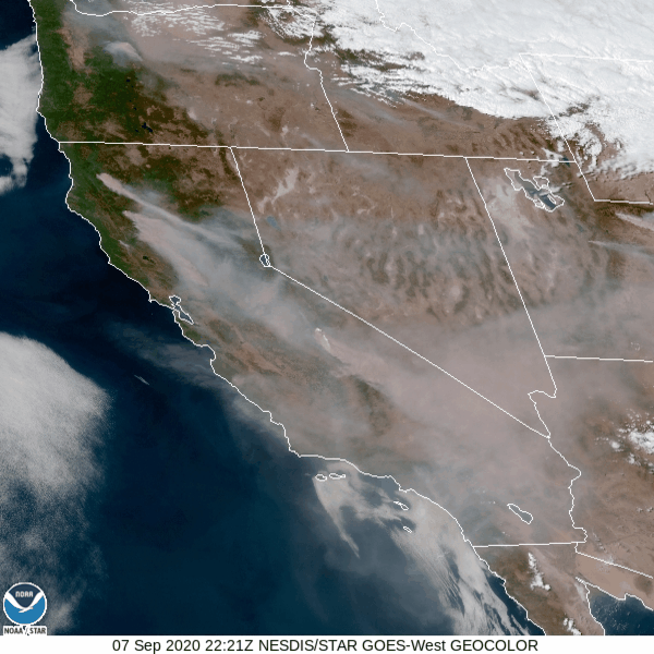
To locate the Oak Fire, see red dot on image below and compare to gif above.
![The red dot shows where the Oak Fire is located. [Image from the GOES-17 Satellite]](https://kymkemp.com/wp-content/uploads/2020/09/The-red-dot-shows-where-the-Oak-Fire-is-located.-Image-from-the-GOES-17-Satellite.png)
The red dot shows where the Oak Fire is located. [Image from the GOES-17 Satellite]
UPDATE 6:46 p.m.: According to a tweet by Cal Fire Mendocino, “[The Oak Fire is] 1000 acres (approx) and 0% containment. [Resources assigned to the fire include] 2 Air Attacks 4 Air Tankers 2 Helicopters 18 Engines 4 Water Tenders 4 Dozers 4 Handcrews 61 support personnel Total Personnel: 232 Additional resources have been requested and are responding to the Oak Fire.”
UPDATE 7 p.m.: Caltrans offers this workaround to avoid the closure on Hwy 101: “A detour around the #OakFire to U.S. Highway 101 is available if northbound traffic takes Route 20 west to Route 1 north to Leggett. Southbound traffic can take the reverse or access Route 128. Please expect delays, and we will provide updates when available.” [NOTE: Hwy 1 has length restrictions. Motorhomes over 40 feet not allowed.]
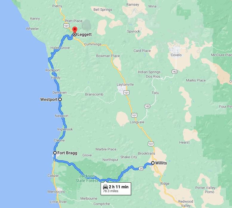
Route around the Hwy 101 closure.
UPDATE 7:25 p.m.: According to Mendocino County 2nd District Supervisor John Haschak, a second evacuation center for residents affected by the Oak Incident has opened up at Baechtel Grove Middle School located at 1150 Magnolia Street in Willits.
UPDATE 7:44 p.m.: Dylan Bouscher, reporter from the Bay Area is getting some incredible and horrifying photos from the Oak Fire. Follow him on Twitter for more.
#oakfire pic.twitter.com/WOOCcvkbEc
— Dylan Bouscher (@DylanBouscher) September 8, 2020
UPDATE 7:53 p.m.: We’re getting word there is a hydration station “for humans and animals at Harwood Park parking lot. Ice water, cups, snacks and hand sanitizer on the porch and hose on side of Harwood Hall. Parking in shade. Stay safe folks!”
UPDATE 8:20 p.m.: According to the Facebook page of Willits Unified School District, “Due to fire conditions WUSD schools will be closed on Tuesday Sept. 8th.”
UPDATE 8:40 p.m.: Looking for help with livestock and pets? Danilla Sands reports,
BEHIND WILLITS HIGH SCHOOLAnimal Care staff is onsight.Opened up for small animals and small livestock at the Willits High School at Farm. Access to the Ag Farm is at the back side of the Skunk Train parking lot follow dirt road aroundto the barns.
Large livestock
Call Sarah at 272-2299 if you need help finding a place for your animals.
UPDATE 8:48 p.m.:The Mendocino Cannabis Alliance through a partnership with Flow Kana is offering space to any licensed cannabis farmers who had to evacuate their product from the areas affected by the Oak Incident: “EVACUEES: Flow Kana has space for product from evacuated licensed farms. First come first serve basis. Please contact Kevin at [email protected] to arrange drop off and intake.”
UPDATE 9:32 p.m.:

UPDATE 9:37 p.m.:
Keep these two pieces of information handy: Google map link: https://t.co/gOLUZGWuMu and Call Center Number (707) 234-6052
The Google map will be continuously updated throughout this event & the Call Center is staffed 24/7 throughout this incident.#OakFire pic.twitter.com/9EHm88k1Jh
— Mendocino Sheriff (@MendoSheriff) September 8, 2020
UPDATE 9:49 p.m.: KPIX has this raw video from the fire today.
UPDATE Tuesday morning: We’ll be updating here: Hwy 101 Remains Closed as Oak Fire Continues in Willits
Earlier Chapter: New Fire Near Willits, Evacuations, Rapid Rate of Spread
Join the discussion! For rules visit: https://kymkemp.com/commenting-rules
Comments system how-to: https://wpdiscuz.com/community/postid/10599/
My thoughts are will our neighbors to the south.
I need to know if Sherwood valley road is open. Trying to get from ukiah to fortuna. Thanks.
I was playing fallout shelter on my phone last night. I ran out of power in my shelter, woke up to a fire spreading through my shelter catching every floor on fire. I use games sometimes to escape reality, promptly deleted that game and threw my phone down.
That’s a really interesting and weird stream of smoke from the Red Salmon complex that’s coming right over Eureka. Kind of on a right angle from the rest of the smoke stream headed south – southeast. I wonder if part of the smoke column reached a higher altitude that has an abrupt shift in wind direction.
I noticed the plume in the sky when I was out walking the dog this afternoon.
Ive been watching that too. The upper level winds are shifting. The NWS predicted it and the smoke will all be shifting offshore in the next few hours. The coast will be smoked in but more important is the direction of those fires will shift. The flanks will become the head. Hope all the Fire crews stay heads up.
I noticed that strange smoke plume yesterday evening too, from freshwater… I laughed out loud when I saw it on one of the fire maps showing smoke direction. Very strange.,..
Holy hell that video the flames must be over 200 feet tall .scary scary stuff .i looked at humidity in willits 11%.
https://www.fire.ca.gov/incidents/2020/9/7/oak-fire/
Red Salmon fire ‘blew up’ this afternoon.
Created a huge column of smoke that penetrated the higher levels of the air column.
Looked really nasty from Eureka.
I’ve been watching it. Here it is on Alert Wildfire a couple of hours ago. It has died down since though.
Am watching the smoke cloud from the Red/Salmon fire east of still clear Miranda moving slowly our way.
That isn’t the smoke from the Red Salmon, that’s from the August Complex.
Here’s a map that gives a better idea. The Oak Fire is north of Willits to help you orient yourself. The Red Salmon is southeast of Orleans and Northeast of Hoopa.
Spraying the coast in Shelter Cove with Geoengineered weather manipulation…increasing wind and making fires worse …Rise UP!
There it is..
Ha
Yep. Its obvious around here if you look up every day, year after year. The RRR isn’t talked about anymore, but it turns on and off like a switch sometimes. There are us patents for many techniques of geoengineering and weather manipulation. The other day BBC radio reported they are cloud seeding in Russia to fight the Forrest fires there.
Solar radiation management. The Governor was apprised of it by Dane from Geoengineering Watch. Ignored of course. SRM is real and has been going on regularly now across the west.
We needed to be reducing our fossil fuel consumption already by about 10% globally during the last couple of of years to address the climate emergency. Instead, by reindustrializing and trying to maintain status quo (subsidizing the fossil fuel economy to keep the global ponzi scheme going), the global emissions have increased.
Thanks to the monopoly of power in D.C., the loyal opposition parties are firmly in control. Banksters and out corporate facists fund the system and as the slam poet A. Olsen once wrote, America’s On Sale.
And we’re all not just fired, but now on fire.
Good night and good luck. We all are going to need it.
You’re right about the threat of climate change and the need to reduce fossil fuels, but lay off the crazy stuff….. there is no conspiracy between the airline industry and the military to spray chemicals on us. It would require an enormous infrastructure to outfit planes with sprayers along with tankers at all the airports to fill the spray tanks along with coordination fake purchase records, thousands of people involved and no one talking, not one photograph…. it’s just the imaginings of people out on the fringe.
there are those who think bigfoot stalks these hills, that the moon landing was faked, and on and on. People fall for these con jobs and probably always will, but please don’t join the crowd.
Oh yeah, It’s conspiracy type of thinking that a industry could ever be harming its public. And who says you would have to do all the people at the same time
Why would you need solar management when smoke is shadeing out more sun the the complicated expensive farfetched ineffective conspiracy method?
I blame China !
What’s making the fires worse is climate change and our continued unwillingness to fund enough fuel reduction to make a difference. Nobody’s spraying chemicals to control the climate. Is this theory something from Q?
Wow. Another conspiracy [edit]
The fire near Mammoth is incredibly explosive.
The change in wind direction is a good thing for getting the fire under control. However,it’s a bad thing if you live downwind in the direction that the fire is moving.
Thank-you Kym for your incredible coverage. I am sure that you and this blogsite have saved lives. As you know you, are appreciated by many, many people. Especially in times like this.
My relatives ask me if I know Kym. I answer “sure I know her she is a friend of mine”. Many people feel that way.
That’s okay, I brag that I know Ernie and Janice. It gives me prestige.
What about medrone way if i spelled that right .in Willits .hav a firend there
So the fire is spreading North of Willits??? I’m new to the community/area and this is my first time experiencing the fires
There are better maps on the earlier story
Keep your radio tuned to kmud and check kyms site often. Also the twitter feed for the fire. #oakfire
Kyms twitter feed for local stuff has tons of info, i check it a lot. Youll see updated fire info there.
Make sure you have firehose fittings for your water tank (s) & leave a map for firefighters to said tanks.
Be as self reliant as possible, most hillfolk are.
Donate to your local volunteer fire dept and as many others as possible.
Have a go bag ready.
Familiarize yourself with the area around you, ie look at a map&see where fire is in relation to you and also how you would get out if a fire starts near you.
All south bound traffic from 101 coming down hwy 1 and branscomb rd thru westport. Single lane construction south of westport blocked due to person who crashed into k rails blocking only way through. traffic blocked for miles both directions.
Those are not fun roads for big trucks. People driving big trucks or big RVs might want to overnight somewhere before the detour and hope 101 opens up tomorrow, especially if they’re not familiar with rt 1 in that area or if they’re tired.
agreed. I brought the length restriction to Kym’s attention shortly after Caltrans Posted the detour information.
Thanks, Jon. I’ve contacted everyone I can think of at Caltrans.
Thanks John, can’t read the sign, but I believe on some gov’t site they don’t advise over 40 ft RV’s. That sign looks like 43 ft ?? But 40 ft is more reasonable. Even at 40 ft a vehicle will go into the other lane around some of those curves. Plus look out for cyclists. It’s nuts even a clear day. Who knows, someone might try it even now.
Was just driving east on Branscomb. It was a total mess. People were trying to drive on it like it was a freeway.
Thanks for the heads up. This is why I keep tow chains and straps in my truck. You never know what they can make that difference in a stressful situation.
Hopefully everyone makes it out safe.
Spraying the coast in Shelter Cove with Geoengineered weather manipulation…increasing wind and making fires worse …Rise UP!
you’re ignorant if you don’t know that all the chemtrails they spray on us make everything much more flammable. they are most definitely controlling and manipulating the weather now.. it’s a fact. do a little research, open your eyes and don’t be a sheep that believes whatever the govt and corp controlled media feeds you.
Nope, chemtrails are not causing the wildfires. The cause is years of fire suppression, massive man-made climate change, and the current wind and heat conditions. https://www.popularmechanics.com/science/environment/a29623250/california-fires/#:~:text=Several%20large%20fires%E2%80%94the%20LNU,and%20years%20of%20fire%20suppression.
So anyone want to play Solomon and decide where the first insult was…? I’m too tired.
Wow, everyone get a load of how aware and not sheep-like this “”yogini” character is. You sound like a puppet. Is there an original thought in your tiny little head?
It’s very clear here who believes everything that’s fed to them, but you got your lines mixed up, parrot.
You got a minor case of microcephaly going on, don’t you? TEENY TINY little head.
Right… bigfoot and the loch ness monster are spraying chem trails over us all….
Why do you think Nature can’t do this, especially after all the abuse She’s received from humankiind on a day-by-day basis?
Belief in this kind of extreme, unscientific conspiracy, is a warped form of self-empowerment: being in on a Big Secret. There’s no conspiracy, just a steady, daily use of fossil fuels, pesticides, plastics, heavy metals and so on for our comfort and convenience. To some extent or another 99% of us, including most hill folk, overuse some of these things. We know what we need to do, but it’s hard and painful — fighting a grand conspiracy is actually easier than giving things up — and it’s so heroic!
Concrete in the cities is a major contributor…concrete covered ground does not adsorb rain water that replenishes the earth.
Therefore it requires more and more water from our rivers.
So the fire is spreading North of Willits??? I’m new to the community/area and this is my first time experiencing the fires
Any information if Sherwood rd is closed? Would like to try and go 101 from 162 to Sherwood rd and down through will it’s
All those routes are closed
I believe that’s the first road they closed
Brooktrails subdivision is NW of Willits. It has two exit routes, one back down into Willits and the second goes north on Sherwood road and connects back to 101 north of hwy 162 to Covelo north of Longvale. From downtown Willits pictures and the one from Shimmins ridge it looks like the the northern route along Sherwood road is burning. Hope that answers your question.
There is also a dirt road from the top near and off primrose that goes south across what looks like a private ranch and ends near the KOA downhill from it. But- IDK, someone might need to crash through a couple of gates in an emergency- if they can. I’ve never been down it. Might need 4wd in spots too, IDK.
The Oak fire is spreading TOWARD the north end of Willits. We got our car packed, jic.
Whats your source for that info?
Why is it California that always has these crazy fires?? Does this not happen anywhere else?? So strange to me unless this does happen elsewhere and we just don’t hear about it.
Fires happen in a number of areas.
Washington State right now…https://www.spokesman.com/stories/2020/sep/07/fire-rages-through-whitman-county-town-of-malden/
Fires in Oregon: https://www.statesmanjournal.com/story/news/2020/09/07/oregon-wildfires-lionshead-beachie-creek-fire-mount-jefferson-wilderness-opal-creek-jawbone-flats/5737812002/
Fires in Colorado right now: https://www.thedenverchannel.com/news/wildfire/cameron-peak-fire-is-now-one-of-the-largest-wildfires-in-colorado-history
Those are just the ones I know of off the top of my head.
Not quite the same. https://www.npr.org/2019/10/23/772775789/washington-state-is-thinning-out-forests-to-reduce-wildfire-risk
Right now Oregon and Washington have about 18 major fires, 90% east of the Cascades. California has a little less than double that, most towards the coast. https://fire.airnow.gov/#
Of course sheer volume does not tell the story. Weather is different, population is different but it does raise questions. Maybe to be looked at later. How’s not the time.
California is as large as Oregon Washington, and Idaho combined. It will snow in Idaho when fire season picks up in So Cal. California also has 10% of the population of the US. Trace the state on a map then overlay it anywhere else in the US. CA is huge. Did you notice CA is dry every summer? Did you know its raining hard in Ohio? Is it a conspiracy, or just easy observations?
wildfires are also a worldwide problem. maybe search for some data first. The Amazon wildfires this year may be the worst year ever beating 2019 which was the worst year ever. 2020 is estimated to be the hottest year on record beating 2019, which beat 2018, which beat 2017, …, which beat 2015. for those that don’t think there is a problem, there is a problem.
Will that make my prime deliveries late?
Wildfire Destroys 80% Of Town Of Malden In Eastern Washington State – https://www.npr.org/2020/09/08/910578980/fast-moving-wildfire-destroys-80-of-small-town-in-eastern-washington-state
Um. Yeah.
havent you noticed the usa map on fires half of us is on fire, really many fires covering half US.
That’s a pretty bad detour… I haven’t been out that way in a decade or so, but I seem to remember parts of it making 36 look nice. And tourists in mobile living rooms…
If you’re trying to get to or from central humboldt or anything further up, your RV will fit a lot better on 20 to 5 to 299.
You are quite right bushytails. That’s a bad detour indeed. Caltrans is irresponsible in directing this amount of labor day traffic off from HWY 101 onto HWY 20 to HWY 1 over Leggett.
At night no less!! They should just stop all except local and emergency traffic.
Taking the “short cut” at night over Branscomb road under these circumstances is completely insane.
Caltrans map will have you think that is just over 2 hours drive.
Nuts!!
Traffic will creep along in an endless column at the rate of the slowest vehicle. There are very few passing spots and with this kind of traffic passing is useless anyway.
With the amount of Winnebagos on the road right now, expect twice normal driving time. Chances are for much further delays due to inevitable accidents due to this irresponsible Caltrans diversion.
What is really frightening is that if a fire suddenly starts anywhere on the road between Rockport and Legget, hundreds of travelers are going to be trapped if not crispy critters. The fires will just roar up the hillside to the top of the road long before Leggett. Even worse is such danger on Branscomb.
Stop at a safe place, sleep in your car if you have no choice and wait at least until morning light.
👍👍👍!
Exactly right! Brancomb road is a tinder box and many live on dead end Rds with no way out except Branscomb rd.
During the 2013 fire when the fire trucks went to the Wilderness fire
a small car couldn’t pass the trucks because the road is so narrow..
And it’s a fire trap between between Westport and Laytonville
Better to book a room in UKIAH OR LAYTONVILLE rather than to risk a accident on Branscomb or Highway 1. Emergency services are stretched thin, shame on caltrans for telling people to use those old stage coach and logging road routes, those roads were not designed by modern road builders
Branscomb road west of Bransomb LITERALLY has a race course “START” line drawn with chaulk at the base of the mountain pass. It’s a fun drive… let’s leave it at that. Not for out of towners… for sure. Already witnessed an accident at chevron in laytonville, not serious but people are acting irrationally. Be safe…
👍👍👍!
Is there even a place to book a room in Laytonville?
Park in the grocery store or Mexican restaurant parking lot.
Flowcanna gunna steel your weed!
Took me four hours to get home from Willits. I took 20 to 1 to Branscomb Road. I drive Branscomb road enough to have each curve memorized; I would not and do not recommend that road to out of towners. I have never seen traffic like I that in my life. People all over the road; I think many headed west to 1 actually thought it was a one way road. Not like there’s lines or anything. And no reflectors at night…
People are going to go off the road.
Or run out of gas on the parking lot that is 1 south. That I couldn’t believe either. Because of that one way traffic stretch at the slide near Westport, every weekending Tesla and motorhome heading back to San Rafael is stuck at that red light. Backed up for miles heading south.
Laytonvillain,
Was traffic still bad when you got to the mill?
That’s an interesting comment Laytonvillain. I had not thought about the problem of driving a TESLA with limited battery power on a road that supposedly takes 2 hours but due to traffic circumstances takes twice or more than that. And after 5 or 6 hours or so you run out of juice!! Hmmm. I think I will keep my diesel and postpone my electric battery car purchase.
And doesn’t even count the potential for PG&E blackouts….no Tesla for me!
It was safer and a better road when it was dirt.
and I think that slide area with the traffic light doesn’t need all that weight and vibration. Even while it’s dry. It’s a disaster waiting to happen one of these winters. It’s massive if you look at the lines above it on google earth.
I was staying in Ft. Bragg since Friday and left to return home to Mill Valley today at around noon.
We drove up the coast north and went to Legett yesterday, traffic was not a problem.
When leaving Ft. Bragg, I noticed some smoke but it wasn’t that bad. I decided to take Hwy 1 instead of 128 to 101 to go home.
Traffic wasn’t abnormally bad going south, in fact in both directions it was light. I knew about the fire near Willits but there was no indication of a diversion from 101 to Hwy 1, traffic through Ft. Bragg was busy, but moved well.
It wasn’t until I got home and called my friends in Ft. Bragg that I found out about the traffic diversion and they said that they had ash on their car, they said that I just got out in time.
Oh well, down in Marin, West Marin was cooler and foggy, but get over the hill into the 101 urban corridor and it was still hot at 6:00 pm and smokey too.
I’m in So Hum, dead car battery. Called AAA, they said 90 minutes, 21/2 hours later I called back to get an update. They said “no drivers available in your area.” Now I reckon they’re all stuck in Willits. Good job I’m in a safe place. They must have their hands full. I’ll just wait until morning and find a local with a battery charger. I’m in good shape. I can’t even imagine what it’s like for our neighbors to the south. Take good care of one another and DO NOT try driving out to the coast! Especially now it’s dark out. BE SAFE.
If you are comfortable doing it, you could tell us where you are and how to contact you and someone might be able to come over and charge it.
Thank you, Kym. How very kind. I’ll see what I can do in the morning. Someone I know might be able to help. Sleep well, if at all possible.
Thanks for the information. I’m a truck driver who runs up and down 101 all week every week. Guess I’ll go the long way up to Redding and over to Humboldt tomorrow.
The bad assness of Kym Kemp’s comments, you just saved yourself a load of horror! Great job KK community! If you are new, this is THE best resource for fire news
Is that you got 2020?! Wow what a year. Summertime isn’t what it used to be. There must be starting to be some kind of actual proof the climate is changing quickly, instead of just ‘evidence’, if you look at how fire has occurred recently. There just weren’t as many fires not that many years ago. Am I right boomers?
This isn’t new news: Let’s not forget that back in the days, a 700 acre fire in Mendocino had 800+ firefighters and was considered big. If the State was serious they would double or even triple down on firefighters. But they dont do it, they dont hire more firefighters even when they know there is unprecedented danger. Instead the state relys on firefighters from other states, from Canada and Australia. WE ALREADY KNOW THESE FIRES ARE GETTING BIGGER AND BIGGER, at some poimt the state and calfire are responsible for failing to adequately staff their departments leaving us all at risk. Why hasnt the state increased its fire budget, increased its number of firefighting aircraft, incresed its personnel? Is it because they purposefully have an agenda to let California Burn, Is it because of UN Agenda 21? Don’t they care about our communities, homes and towns? It has been obvious we do not have enough resources to fight these fires successfully, maybe we need to take all those agents working on the Cannabis Eradication teams and train them to do something productive with their lives like fighting fires. When there are fires the eradication teams should immediately stop destroying our farmers and neighbors livelihoods and should begin fighting the fires, where is our Sheriff Departments priorities, are they really in stealing from our already broke communities in the name of ego and power trips. Time for a change!
More money for firefighters less money for politicians would be a good start.
Firefighters, police, good mental health care, and schools should be priorities but always seem to get short changed as bureaucracies suck up the monies.
We certainly weren’t told about them. Nor were there passable roads with people living everywhere. We still had some pandemics, wars and famine to check reproduction. The point to worry about is not whether industrial production and massive population increases have changed the climate but whether people from immigration and antipoverty advocates to corporation and grow owners have the will power to get off their personal agendas, accept the consequences of their own behavior and sacrifice their own agenda for changing it anyway. I do not think one of them will. Instead they will blame others and continue on their merry way. So it’s better to think about coping with drier, more extreme weather as best as possible no matter what blame is being assigned to whom. The old aphorism that you can’t eat your cake and have it to comes to mind.
Where can I find the most current traffic conditions for the area including the 101 closure?
Seems there was a lot of fires down by LA years ago now it seems that everything up here is burning
When the dogwoods lose their leaves in July, and the Oaks start turning brown in August, you know there is something very serious going on with our local climate. All you gotta do is watch mother nature. The local hills are drying out faster due to a thinner ozone layer which increase UV and Solar radiation thereby drying out the ground moisture earlier in the year. Not to mention our forests are no longer hundreds of feet tall with old growth that acts as insulation from the beating down rays of the sun. Old Growth trees like Redwoods and Firs dont crown out during a forest fire either, the fire burns the chaparral under the trees and rarely crowns out in the tree. These fires are fueled by 120 years of brush growth since California Department of Forestry refused to let fuel loads burn for the last century. The regular “fire pattern” in this area is much smaller fires every 7-25 years. We better just hope these fores dont end up in all that Herbicide Sprayed Tanoaks on Mendocino Redwood Con-pany lands West of this fire. There are literally millions of dead trees which were left standing after Mendo redwood company (Gap-Old Navy Fischer Family) sprayed and left standing as dead dry hillsides. Shame on Mendocino Redwood Company, they also REFUSE to stop burning wood pellets in Redwood Valley during these fires despite the air quality being at the very worst possible with smoke and ash falling : Mendocini Redwood Company are bad neighbors who do not care for our communities. Money is their bottom line $$$
🕯🌳Your the best Kym, keep the information and updates coming. But get some rest please.
Looking for updates on the Oak Fire for Sept. 8. What areas burned in the overnight fire? Son’s property is up there. He is in a safe place right now.
If anyone has information regarding exact perimeter of the Oak Fire please post it. I live smack dab in the middle of the evacuation zone and can’t tell what’s going on since 7-something last night when Cal Fire Tweeted last. We gotta wait over 12 hours to find out if our home burned down?
Any updates this morning? Thanks Kym.
https://kymkemp.com/2020/09/08/hwy-101-remains-closed-as-oak-fire-continues-in-willits/
(For Lone Ranger)
What’s the big deal?
Willits is over 85 years old.
Old cities die.
Fires were here last year.
(For Stars)
Zero deaths, zero hospitalizations.
(For Ullr)
There are more acres not on fire, dont panic. Our Founders dealt with fire too.
(For Guest)
Liberal media always is overblowing the risk of fire, when they rarely mention a flood. Liberal Bias.
(For E. Branscomb)
There are too many cities.
(For HotCoffee)
Bill Gates was in Ca today, maybe dropped by Willits?…
(For me)
Good luck out there.
Brian,
Anyone heard from Nancy Pelosi while her State burns?
Kamala maybe? Gavin?
This thread is for the fires OK Brian not cheap shots.
I’m not seeing any maps of the actual fire line.. Just evacuation boundaries.. Even CalFire has nothing yet..
It doesn’t look like they got an IR flight in there which makes mapping more difficult.
Any updates from commenters on Branscomb rd and conditions and Laytonville would be helpful, I need to go to town this afternoon.
There is no risk from the Chinese fire. Drive free. Its America.
Dude you need to get a life..
Is that a new Herman Cain joke?
Nicely done.
Can anyone let me know if northbound traffic is shutdown. I’m trying to get from ukiah to fortuna…is sherwood valley road shut down going northbound?
Call 1-800-GAS-ROAD for latest hiway conditions and follow the prompts.