
Mendocino Complex Devours Almost 25,000 Acres (Maps, Photos)

River Fire, near SR 29 and Hill Road late yesterday afternoon. [Photo from Caltrans District 1]
One fire, the Ranch Fire, has burned 13,242 acres just north of Hwy 20 and south-southeast of Potter Valley. The other, the River Fire, has burned 11,028 acres less than a mile east of Hwy 101 between Hopland and Ukiah.

Mendocino Complex
Last night a widespread power outage left over 50,000 residents of Lake and Mendocino Counties without electricity. Overnight the power was restored to most residents by 3 a.m. According to California State Senator Mike McGuire, PG&E “has determined the outage was caused by heavy smoke around the electrical lines (heavy smoke is a conductor of electricity) in the Hwy. 20 area.”
The Plan:
For the Ranch Fire, crews will be struggling to keep the flames north of Hwy 20, west of Middle Creek, South of Burris Lane and east of Potter Valley. See here for information on road closures and evacuations.
For the River Fire, crews will try to keep the fire from extending east of Old River Road, south of the Off Highway Vehicle Park, west of Hwy 29 and north of Hwy 175 which is currently closed. See here for information on road closures and evacuations.

This Ranch Fire photo was taken from Hwy 20 about 2.5 miles west of SR 29 late yesterday afternoon. [Photo from Caltrans District 1]
The Weather:
Temperatures are expected to soar to the high nineties and even to 104 in the valleys. The humidity is expected to be below 15% and could drop to the extremely low 7% range.

The River Fire, near SR 29 and Parkway Interchange late yesterday afternoon. [Photo from Caltrans District 1]
The MAPS:
- Ranch Operations Map –to see details either zoom or click on the map and download a pdf.
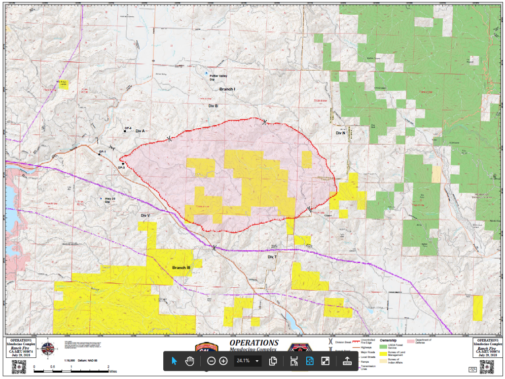
Ranch Fire
- River Operations Map –to see details either zoom or click on the map and download a pdf.

River Fire
- KMZ Map–Zoom for detail or for 3D imagery, click on the map and download a file that connects with your Google Earth program.

Mendocino Complex

UPDATE: The Two Fiery Claws of the Mendocino Complex Squeeze Clear Lake and Its Communities (Maps, Photos)
Earlier Chapters:
- Mandatory Evacuations for River Fire 4000 Acres / Ranch Fire Grown to 1000 Acres
- Thousands Without Electricity in Lake and Mendocino County as Major Wildfires Rage
Join the discussion! For rules visit: https://kymkemp.com/commenting-rules
Comments system how-to: https://wpdiscuz.com/community/postid/10599/
Thanks Kim for your informative site. I travel between Mendo and Humco and I really appreciate the information..
And thanks for not using facebook for comments.
Sure hoping Hwy 20 or Hwy 101 stay open.. feeling boxed in a bit, fires all around.. thanks for the updates Kym, your the best hands down
Updates appreciated. Excellent photos show the magnitude of these fires.
Why is Lake County area so prone to such large fires? I can understand such fires on the east side of mountains but the west side is usually not as dry.
Because there’s lots of morons in lake county….
West side hills are also very dry in Mediterranean climates like California.
North slope is the dark side of the mountain.
Praying that all the fire fighters and local citizens will be OK. Thank you Kim for the updates and nice pictures giving us a visual of the fires. Sure hope these were not arson.
Are these fires arson?
PaulVonVONYER Rank 149
Just random fires marching across California due to
“incendiary” geoengineering fallout and relentless drought? Talk about “plausible deniability”!!! Fine, ok, but there is no one here or anywhere else on the net that will convince me that there isn’t an “intelligence” behind the IGNITION of these fires. We have been using the “WEATHER WARFARE” term for years on this site. It doesn’t take a genius to see the obvious patterns developing here over the last several years. RANDOM (?) ignition due to heat, drought, etc??? ********! These fires are not just collateral damage due to years of geoengineering. Weather warfare IS arson!! I’ll say it again in case you didn’t hear me. Weather warfare IS ARSON!!!! I welcome any responses from other folks, here. However, if we continue to refuse to see what’s right in front of our faces we deserve everything we have coming to us. These worldwide fires are by intelligent design and are thus one and the same as arson. Don’t share this view? I could not possibly care any less at this point. —from Comment section on below link
https://www.sfgate.com/local/article/Worlds-largest-fire-airplane-supertanker-carr-13111197.php#photo-14315724
The one in Shasta County was started by a vehicle failure. People think a spark caught dry grass on fire. I haven’t heard about the other fires.
Only fires getting press down here Central Coast) are Carr(?) and Yosemite. Prayers for all!!
Thank you for your informative article. I’ve been looking for ways to post our fire information on websites, such as The New York Times and Bay area tv stations, with no success. Maybe you have what it takes to get our small and very important counties recognized by big media. That would be great. Stay safe and hydrate, everyone! Thank you.
Thank you so much, I have been looking all over for those KMZ files
Wake up people: Remember Kim Jong Un said “prepare for fire and fury” and also remember the US was extremely scared of an attack by North Korea using engineered storms….. Now we hear the term firenado…..
https://www.globalresearch.ca/the-ultimate-weapon-of-mass-destruction-owning-the-weather-for-military-use-2/5306386
US Airforce Document from 1996 shows proof of wether manipulation for military interests
Weather As A Force Multiplier: Owning The Weather In 2025 Weather As A Force Multiplier: Owning The Weather In 2025 Weather as a Force Multiplier: Owning the Weather in 2025
PDFAF.mil › au http://csat.au.af.mil/2025/volume3/vol3ch15.pdf&ved=2ahUKEwiurZXJzMXcAhUjnq0KHW4EDd4QFjAAegQIARAB&usg=AOvVaw1LyquvgV4RcXXTAIZBqIMg
Sunday night – 9pm: Electricity is BACK ON in Ukiah City (that has its OWN Municipal Electric Utility WITHIN the City Limits). Unknown about rest of Mendo County that gets its power from PG&E.
https://www.facebook.com/cityofukiah
I’m still seeing people throw lit cigarettes out their windows, why isn’t something being done about this, there should be an active campaign to stop this and no agency ever addresses it. I was behind a silver car with Utah plates using 20 as their ash tray and sure enough when the female driving was done, out the window it went and I immediately pulled my air horn well they turned off 20, must live there and just haven’t registered their car in California.
Thanks for nicely orgainized info.
*****************
I sent this out last Oct. 2017 to my friends and family via email.
I am now posting this publicly : for the concerned info. value.
With Fire Season here, and hot weather ahead of us,
and wild fires nearby … Here’s a way to “add
to your references” for fire risks for any location. I acknowledge I am NOT a
Fire Fighting professional! I also very much appreciate the way our
local emergency authorities handle such huge responsibilities.
******************
These website links are worth keeping/ filing
Re: Accessing Nearby Wildfires & Accessing Risks:
… Using this Fire Data Website: on can see about any fire in the U.S. … in current data status
(I believe the fire data is updated about once per hour)
https://maps.nwcg.gov/sa/#/%3F/36.1157/-120.4949/5
you have to magnify with + button while moving map to put area you are looking at … right in the center.
I will take desktop pictures with time & date noted, to compare with next time I look for fire progression reference.
*******************
I also found the following info. valuable after that Oct 2017 Fire Storm that blew through my Redwood Valley, CA community.
At that time … I saw wind predictions of only 10 mph “max” from WNW (North, Northwest) … after Oct 2017 fire …and less during the week on the wunderground website. While that is not the best of situations, that was NOT the 30 mph with 60 mph gusts from the East predicted for the North Bay Area (at that time)!
I now favor: https://www.wunderground.com/forecast/us/ca/redwood-valley/95470
for wind predictions info. because it seemed to be more accurate in wind predictions than accuweather.com .
and for Potter Valley: https://www.wunderground.com/forecast/us/ca/potter-valley/KCAPOTTE3?cm_ven=localwx_10day
Hit: “10 day” (if it only shows one day) for your area code; see 10 days worth of predictions; and look at the wind graph: The wind graph includes arrows indicating changing wind directions. The heights of the wind graph indicates wind speed in mph … (all predictions) for various parts of the day. … One can also adjust to different zip codes (maybe also via map) to see predictions for other locations. A customization button includes an option to show humidity which usually rises at night, … too.
As a retired Commercial Sea Urchin Diver who has looked over so many weather reports and real time ocean weather data, I am impressed with the wind graph and humidity reading option . Personally, I found the above website info. links (along side info. from our emergency responders) to very useful for in accessing my personal risk concerns after that Oct. 2017 Fire Storm.
Down Wind of a nearby Fire is the Danger Zone. The info. at wunderground are just predictions (though usually accurate).
Wind directions can change!
********
Have a Good Day +) From, William Self … in Redwood Valley
Thank you, Look up.
They must find it difficult . . .
Those who have taken authority as truth,
Rather than truth as the authority. -G. Massey, Egyptologist
You mention North Korea. North Korea is one of only three countries left that does not have a Rothchild owned Central Bank.
Also, it’s okay to grow hemp in North Korea. Let that sink in for a minute.
Afghanistan, Iraq, Sudan and Libya succumbed to Rothchild Central Banks after 2003Central Bank free until 2003.
All wars are banker’s wars.