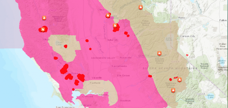
Last night thousands of acres caught fire across California. The vast majority of those acres occurred above the narrow area which stretches from the San Francisco Bay to Lake Tahoe. The pink area of the map above indicates that the kind of weather conditions that make fires more likely exist there.
The pink area of the map above indicates that the kind of weather conditions that make fires more likely exist there. The dark red areas are roughly where hot spots were photographed by satellite early this morning. At this point, we do not have more exact maps.
The Fires That Started Burning in Northern California Since Yesterday Afternoon:
| County: |
Napa County |
| Location: |
off of Hwy 128 and Bennett Ln, Calistoga |
| Acres Burned – Containment: |
20,000 acres |
| County: |
Sonoma County |
| Location: |
Hwy 12, north of Glen Ellen |
| Acres Burned – Containment: |
300 acres |
| County: |
Napa County |
| Location: |
off Patrick Rd, west of Napa |
| Acres Burned – Containment: |
100 acres |
| County: |
Mendocino County |
| Location: |
North of Hwy 20, west of Mendocino National Forest, south of Black Bart |
| Acres Burned – Containment: |
4,500 acres |
| Evacuation Info: |
Evacuations are in place for Redwood Valley.Evacuation centers: Ukiah High School and Willits City Hall.
The large animal evacuation center is at Ukiah Fair Grounds. |
| County: |
Butte County |
| Location: |
off Cherokee Road and Zonalea Lane, Oroville |
| Acres Burned – Containment: |
1,000 acres |
| Evacuation Info: |
Evacuation orders issued for Red Tape Rd. West to the Sand Mine. Table Mtn Ranch east of Table Mtn Rd. Table Mountain Blvd from the Cottonwood Rd. to Hwy 70, Table Mountain Ranch & Coal Canyon & Roads off of those streets.
Evacuation Warnings: East side of Cherokee Rd. from Red Tape Rd. to Derrick Rd. All of Coal Canyon Rd. Nelson Ave. from the bridge over the Forebay west to Wilbur Rd. |
| County: |
Nevada County |
| Location: |
McCourtney Rd and Hwy 20, Grass Valley |
| Acres Burned – Containment: |
200 acres |
| County: |
Mendocino County |
| Location: |
Busch Lane, Potter Valley |
| Acres Burned – Containment: |
1,500 acres |
| County: |
Calaveras County |
| Location: |
Hwy 26 and Higdon Rd., West Point |
| Acres Burned – Containment: |
150 acres |
| County: |
Butte County |
| Location: |
La Porte Rd and Oro Bangor Hwy, Bangor |
| Acres Burned – Containment: |
3,000 acres |
| County: |
Yuba County |
| Location: |
Cascade Way and Marysville Rd, north of Collins Lake |
| Acres Burned – Containment: |
2,500 acres |
| County: |
Humboldt County |
| Location: |
off of Blue Lake Blvd and Hwy 299, east of Eureka |
| Acres Burned – Containment: |
20 acres 50% contained No structures destroyed. |
The Roads:
Caltrans reports as of 9:22 a.m.,
With U.S. Highway 101 closed by wildfires in Mendocino County, we’ve arranged for the federal contractors on Route 36 to allow traffic queues through the work site on Buck Mountain in Humboldt County to improve access to and from Interstate 5.[The crosed out area is not accurate.]
Additionally, Route 299 reopened to one-way controlled traffic on a 24/7 basis at the Helena Fire closure near Junction City in Trinity County. Motorists should anticipate approximately 60 minutes of delays between Arcata and Redding.
Route 20 in Lake County has not been closed by fire activity yet, but changing conditions could result in a closure at any time. Some local roads which intersect with Route 20 *have* been closed, which resulted in some miscommunications earlier this morning. Route 20 remains open at this time.
There is still no estimated time to reopening U.S. Highway 101 near Redwood Valley.
UPDATE 10:48 a.m.: One Dead, Multiple Structures Burned, Numerous Injuries, One Looter Arrested in Redwood Complex Fire


Join the discussion! For rules visit: https://kymkemp.com/commenting-rules
Comments system how-to: https://wpdiscuz.com/community/postid/10599/
What an insane night. The “perfect” firestorm. Following with the MODIS satellite imagery, some of these fires were growing at a rate of 50+ acres PER MINUTE into residential areas. Incredibly long range spotting with the high winds.
Thanks for the updates Kym
Why did so many fires start at more or less the same time? Seems a little odd…..Any information on this other than speculation?
The areas where we have fires saw very windy conditions last night. I’ve seen quite a few pictures this morning of trees knocked over and topped in western Nevada County. It’s safe to assume these are mostly power line related.
My understanding is a combination of ferocious winds, trees into swaying power lines, arcing electrical fire, wind carrying sparks and ash many miles from source fires and starting new fires…
I’ve been watching these fires since 4am.PLEASE PRAY for everyone this is a really bad one. Lots of winery’s gone,community’s gone it’s heartbreaking.🙏🙏🙏🙏watching evacuations from the Sutter hospital with flames shooting out behind them.same at kaiser!devastating
Time to put the power lines underground.
and not throw lit butts out your window.
Just called Cal Trans & they’re (as of about 1130 hours) listing Hwy 101in Santa Rosa area closed. So, if Hwy 20 does close and 101 Willits is closed, alot of folks are unable to get out or home. Call before you leave. Santa Rosa is under Central California on Cal Trans information line.
It’s partrick. Not Patrick.
I’m saddened for those being affected by the fires. Trinity County understands the fear, shock, and loss you are experiencing. Many amazing firefighters helped our community, and I know that they are putting forth their best efforts for you, as well.
My brother lives in Sonoma city, the area looks like a scene from a horror movie, Armageddon