
The Red Salmon Complex, Burning in Humboldt, Trinity, and Siskiyou Counties, is Now Over 1000 Acres With 0% Containment
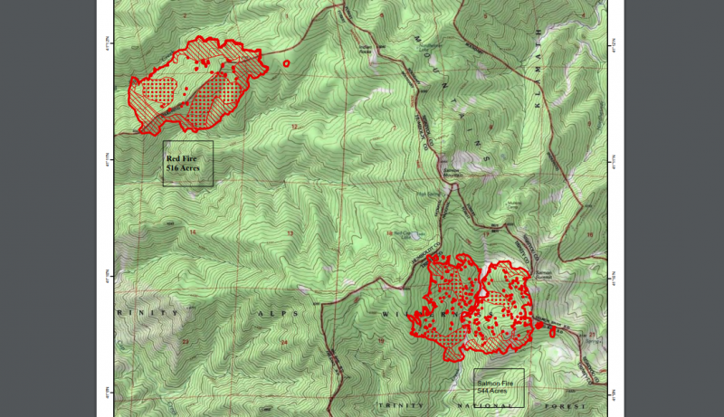
Red-Salmon Complex Map 7.31.2020
Information from InciWeb:
The Red Salmon Complex continues to burn in remote wilderness areas of the Six Rivers and Shasta Trinity National Forests. This Complex includes both the Salmon Fire and the Red Fire which currently are a combined total of 1,060 acres and 0% containment.
Firefighters are using a full suppression strategy and utilizing indirect fire attack methods to gain control of both fires. A combination of both ground crews and air resources are being used due to the rugged terrain and challenging access. Multiple helicopters with water bucket drops are supporting ground operations. A helibase is now operational in Willow Creek to provide helicopters with a quicker response to the fire areas.
The Red Fire is currently 516 acres. Firefighters are currently working from Salmon Summit to the south along the ridgelines to open up previous fire containment lines. Crews continue to look for control line opportunities on the west side of the fire.
The Salmon Fire is currently 544 acres. Fire crews continue to strengthen and improve the ridgeline from Salmon Mountain to Megram Ridge using previous fire control lines and previous fire scars. The fire has reached the ridge in this location and firefighters are actively holding the fire. Crews are looking for opportunities and locations to secure the southern end of the fire back to Back Done Ridge.
California Interagency Incident Management Team 14 is working actively to prevent the spread of COVID-19 through various control measures. Firefighters are screened every morning with a temperature check and health screening. Firefighters are also practicing social distancing, frequent hand washing, and wearing face coverings throughout camp and as appropriate during operations.
In addition, the USFS also states, “Beginning [today], July 31, 2020, the Big Rock River Access will be closed in the interest of public safety due to the River Access Point being used for water bucket operations by helicopters aiding in the fire suppression efforts on the Red Salmon Complex.”
Join the discussion! For rules visit: https://kymkemp.com/commenting-rules
Comments system how-to: https://wpdiscuz.com/community/postid/10599/
Good luck to the firefighters on these fires, it appears as if they can use ALL the Luck they can get!!!! :-[[
🕯🌳I’ll second that. 👨🚒👨🚒🌍
I know that area and when they say steep they mean WAAAAAAAAYY steep. I was at a fire in that area in the 80s and we watched as rocks rolled from the top of the ridge, 2000 vertical feet to the river bed. Good size boulders as big as basketballs let loose by the fire. It looked like the rocks were advance storm troopers clearing the way for the fire. needless to say direct attack was impossible.
I just read that two air tanker pilots died yesterday when their planes collided. Down in southern Nevada. 14,000 acres burning.
It’s a tough business, and all have my complete respect.
Covid related? County officials will blame the virus. All bears need to mask up!
That is Devil’s Backbone Ridge not the Back Done Ridge as in the quoted article. Devil’s Backbone Ridge is the dividing line between Six Rivers and Shasta-Trinity National Forests and Humboldt and Trinity counties and is the location of a fire line from the Megram fire of recent years. Devil’s Backbone is the ridge that runs south from Salmon Mountain and divides Red Cap Creek (that flows into Klamath) from Virgin Creek that flows into the New River then Trinity River.
There was a large helicopter dipping water from the Klamath last yesterday afternoon several miles downriver from Orleans but have not noticed that activity today.
The helicopter with water bucket is working again. Looks from my home that the water is being dipped from rhe Klamath between Ullathorne and Boise Creeks, that is about 10 crow miles from the Red Fire component of the complex.
Have observed 3 and maybe 4 helicopters dipping water in steady rotation now for 45 minutes; there is a large Chinook now dipping water near Ruben’s Riffle on Orleans Bar. I say 3 or 4 helicopters as there is the Chinook, what I think is an S-61, and one or more smaller ships.
Lots of aviation fuel as 10 miles one way as a crow flies to the fire.
This fire has potential to go large and burn for weeks because of location. Seems like at least half of recent years, fire have started around this time of Summer and left the Klamath canyon under severe smoke.
Not good for the firefighters especially in this time of virus.
I’m going to take a stab and say this fire stays under 5k acres. It’s essentially top of the ridge and it’s not spreading that quickly at that elevation. As long as there isn’t a big wind event and not too much roll out… I’m not sure if they are funneling the red fire into the salmon, but, so far, it doesn’t want to blow up. Hopefully this will force some maintenance on Devils Backbone.
If there is another, higher priority fire elsewhere that pulls resources off this one that may change everything.
Is it smoky in Eureka, Arcata?
Thanks.
There is a bit of smoke above the fog… along the north coast.
Probably why the fog isn’t pulling out of the immediate coastline
nope, blue sky in Eureka
Smoke on the Klamath, this might be it for blue sky summer
Not much smoke at all yet but when major fires occur part of the smoke goes with gravity down the River canyons. Alas.
I’m upriver 50 miles or so,
Seems more clear now here, but the smoke haze was mottling up the ridges earlier.
We had some lightning spot fires around Athithufvuunupma earlier this week, not sure if the feds and tribe got those all out
https://twitter.com/ShastaTrinityNF/status/1289598688206172160?s=20
Morning update.
No helicopters so far today. Some smoke. There was a semi inversion this AM but that is gone but there is still smoke and the smell of smoke. Added lots more people to the fires than two days ago.
https://inciweb.nwcg.gov/incident/6891/
About 3 PM, helicopters started dipping water out of the Klamath near Orleans again and worked for several hours.
https://twitter.com/ShastaTrinityNF/status/1289769080610631680?s=20
8/1/20 @ 9pm PDT update
Thank you to all the men and women Firefighters for all they’re doing!! Being a firefighter is a very risky job and a rewarding one as well. Be safe and watch over each other out there.
These two fires will merge and become one large complex. Then with the Trinity Alps restriction not allowing any equipment for on ground attack, we’ll see this monster grow and grow. There have been fire(s) years ago in the Alps and they burned for months without full control. Hope for rains earlier than normal because it looks like a long potential 10,000+ acre fire
1800 acres. 8/2/20 morning update :
https://twitter.com/ShastaTrinityNF/status/1289950522347122689?s=20