
Crews Hope to Garotte the Carr Fire With a Thin Ribbon of Flames

A cloud of smoke from the Carr Fire confronted dozer drivers last Saturday afternoon. [Photo by Stephen Thomas Riley]
So far the fire has consumed 181,496 acres and is only 51% contained. Though the fire’s increase in size has only slowly crept upwards the last few days, winds and high temperatures which forced the announcement of a Red Flag Warning are worrying those battling this beast.

Cracking a thin whip of flames, crews set backburns above the northern head of the monstrous Carr Fire. [Crop of today’s heat map]
Shasta Bally repeater has limited operability due to damage from the fire. This repeater is critical to the public safety radio system. A mobile repeater is being placed on Sugarloaf. The South Fork Repeater site has sustained major damage. This site hosts the local AM/FM radio stations and local TV, including local news. Other components damaged at the site include AT&T cellular site.
For more information on evacuations and road closures, click here.
The Plan:

Crews consult about where to put in containment lines. [Photo by Stephen Thomas Riley]
Branch II, the southwest of the fire: The fire is pushing south through the mountains around Rainbow Lake and across the County Line Road north of Bully Choop Mountain. Afternoon winds may cause torching and crown runs.

The Carr Fire as seen from the driver’s seat of a dozer. [Photo by Stephen Thomas Riley]
Branch IV, the north side of the fire: The north of the fire pushed past dozer lines and firefighters will have to deal with winds from the south and west today. Spot fires pushing across already established lines are also a problem. However, a massive backburn yesterday (see above) has been added to the firefighter’s arsenal of weapons that they hope to use to choke the beast.
The Weather:

Sunset over Whiskeytown Lake. [Photo by Stephen Thomas Riley]
The humidity will be low and the temperatures will be high (up to 103 degrees in some areas) as it has been through much of the fire.
Look for some improvement in smokey conditions today.
The Roads:

Caltrans road sign thanks first responders. [Photo by Stephen Thomas Riley]
While firefighters and other emergency personnel continue efforts to contain the Carr Fire, the California Department of Transportation (Caltrans) District 2 announces the limited reopening of State Route 299 between Redding in Shasta County and Weaverville in Trinity County. The roadway has been closed at several locations since the fire broke out on Monday, July 23, 2018, for public safety.
Effective Thursday, August 9, 2018, State Route 299 is open on a limited basis, as follows:
- The public can drive through between Trinity Dam Blvd and JF Kennedy Memorial Road (Whiskeytown Visitor’s Center) from Noon to 1:30 PM and 6:00 PM to 5:00 AM daily. The highway will remain closed during all other times.
- One-Way Traffic Control Operations will be in place. Motorists are to follow a pilot car, slow down, and follow directions. PLEASE DO NOT ARRIVE MORE THAN 15 MINTUES EARLY TO TRAFFIC CONTROL. Early arrivals will be turned back.
- Motorists are advised of possible significant delays.
- This schedule is subject to change at any time.
- Caltrans, contractors and subcontractors will continue diligently repairing State Route 299 while traffic travels through.
- These hours pertain to repopulated communities as well. Caltrans, its contractor Tullis Inc. and subcontractors have been working nonstop since Tuesday, July 31st at several stretches of the highway, removing thousands of burnt trees deemed hazardous to the traveling public, replacing several miles of damaged guardrail, road signs, and culverts, along with dozens of crews from utility companies who are repairing key infrastructure.
“In the aftermath of the Carr Fire, all agencies involved are doing their best to manage this critical situation,” says Dave Moore, Caltrans District 2 Director. “Caltrans has been focusing on reopening State Route 299 as soon as possible and at a point when we deem it safe for the traveling public.”
Caltrans continues asking for the public’s patience and understanding. Caltrans is committed to informing the public as often as possible.
Caltrans District 2 is informing the public through the “Caltrans District 2” page on Facebook and “@CaltransD2” on Twitter, via our website, the (530) 225-3452 hotline and our one-on-one customer service via telephone to those who call (530) 225-3426 during business hours.
More information about the closure from Caltrans District 2 below:

For more on other roads in the area, see this Cal Fire site.
The MAPS:
- Operations Map –to see details either zoom or click on the map and download a pdf.

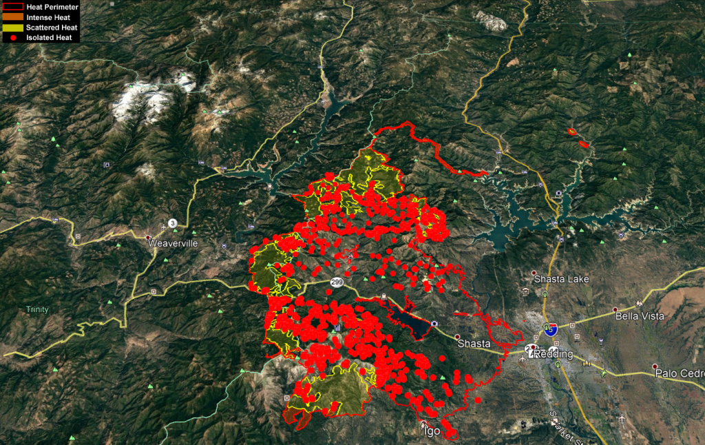
Carr Fire Operations August 10
- KMZ Map–Zoom for detail or for 3D imagery, click on the map and download a file that connects with your Google Earth program.

Carr Fire Heat Map August 10

Donations:

- Stuffed Toy Drive in Eureka, Weaverville, and Willow Creek for victims. (See more information here.)
- Northcoast Horticulture Supply is working with Pay It Forward Humboldt to collect donations for the Carr fire.
McKinleyville 1580 Nursery Way
Arcata 639 6th St
Eureka 852 W Wabash Ave
Fortuna 126 Dinsmore Dr
Note: “Pay It Forward Humboldt has asked us to collect gift cards and N95 respiratory masks only at this time. We’ve tried to be specific about what’s needed at this point in time in our social media because folks tend to drop off random and sometimes heavy items that are not useful until folks can set up temporary housing. Once they have the donation centers set up over the next days/weeks, they will be accepting clothes, household donations and larger items.”
Resources:
Redwood Acres Fairground is accepting evacuees for free camping.
Earlier Chapters:
- Fire Near Whiskeytown Closes Hwy 299
- Carr Fire: Map, Detour for 299 Closure, etc.
- Carr Fire Reaches 4500 Acres; 299 Still Closed (Maps, Photos)
- Hwy 36 to Completely Open Today and Tomorrow to Help Ease Travel Issues After Carr Fire Closed 299
- Expect Smokier Conditions in Northern California, Says Weather Service
- Carr Fire Jumps Sacramento River; Western Redding Being Evacuated
- Two Dead and Thousands Displaced as Carr Fire Tears Into Redding
- Images From the Carr Fire and the Smouldering Devastation Left Behind It
- The Carr Fire: Almost 90,000 Acres Burned [Photos, Maps, Video]
- Carr Fire Pushes Into Trinity County; Evacuations
- The Carr Fire Switches Attack: Some Redding Area Residents Allowed to Return Home; But Trinity County Residents on Edge as It Turns on Them
- Carr Fire Threatens Trinity County and Communities to the Southwest of Redding
- The Carr Fire Glares Down Into Trinity County as It Continues to Grow [Maps Included]
- The Carr Fire: 131,896 Acres and Growing [Maps]
- Another Dead as the Carr Fire Grows (Maps)
- Another Dead on the Carr Fire
- Former Bridgeville Firefighter Killed in Accident on His Way to the Carr Fire
Join the discussion! For rules visit: https://kymkemp.com/commenting-rules
Comments system how-to: https://wpdiscuz.com/community/postid/10599/
So… add 50k acres to fire. That’s a lot of earth between the main body of the fire and the backfire.
I was thinking the same thing last night when I saw the VIIRS returns from that backburn. Also The two fires growing on the other side of I5 up an arm of Shasta Lake.
Two fires are on Gilman Rd. E
East of I5
https://inciweb.nwcg.gov/incident/6116/
They are the Hirz fire.
I used to have a home up there off Gilman (old mill rd). Too much poison oak, ticks and mosquitos for me.
…
Did they use this?:
https://youtu.be/u1kpobfCgAk
The Helitorch:
https://www.wired.com/2015/08/flame-throwing-helicopter-fights-wildfires/
Helitorches are rarely used now. There is a better choice that mounts in a helicopter that drops ping pong balls that slowly ignite on the ground.
Also there is no firefighting term of “Backburn”. There is a ” Backfire” , which is an indirect tactic, the one you are describing here, and a ” Burnout” which is a small scale direct tactic to secure a piece of fireline. But no ” Backburn”. Kym, Please use the correct terms..
Merriam Webster thinks backburn is a term: https://www.merriam-webster.com/dictionary/back-burn
I have been a Wildland Firefighter for over 35 years. The last 10 as a Fire Chief with the USFS and a Fire instructor. “Backfire” is the correct usage for the indirect firing described in the article. “Burnout” is a small fire to secure a line. Some technical terms used in professions are not well understood in general public. I have no idea why that dictionary entry is there. I did notice that entry quotes 4 civilians and not one Fire professional on the word..Back in the 1940’s and 50’s that term was used that way, it’s still used commonly by the public but is no longer the correct term.. There are also entries for “Borate Bombers”..which we now call in common use Air Tankers…
I still like “borate bomber” over Air Tankers. Isn’t the red fire-retardant material still the same? Borax-based? What’s the linguistic difference between “backfire” and “backburn” anyway?
Thank you for all your work.
(Hey Kym, why do I have to re-register all the time?)
Kym doesn’t like grammar and spelling corrections. Personally, I think they are OK if accurate. Public education has failed many or vice versa.
I don’t mind people correcting me. I just don’t want the comment section to be about grammar.
Hopefully, you should only have to register every few weeks now. Let me know if it is happening more frequently than that.
This is not a “small scale” tactic.
Nope, not small scale at all. I measure about 17.6 miles of firing off the containment road / dozer line.
And it’s starting to fill in quite nicely:
https://maps.nwcg.gov/sa/#/%3F/40.7097/-122.5095/11
They model all the possible scenarios regarding containment and fire behavior, this is the longest firing operation I have seen on Infrared. The firing ops were performed by USFS crews, mostly at night under the inversion to prep for today and tomorrow. Quite a plume this afternoon up above the Indian Creek headwaters too.
Just used the area measurement tool on the above linked map, if the whole area inside the existing fire and the “containment” line burned down to the lake edge it would be approx. 40,000 acres, actually more because that tool is 2d, so with terrain maybe closer to 50k. Good guess above Ullr rover.
No, that is Backfiring, the large scale indirect tactic.
I doubt that Merriam is out there fighting this fire, the terminology used really doesn’t matters much, but backfire and burnout are the terms used nowadays.
The terminology can be important for the public to understand. They need to know rhe difference if a Fire manager shows up at their door and days” we need to do a few burnouts on your property”, or ” we are going to do a backfire on your property”. One could be 1 acre, one could be 30,000 acres. The more the public knows the correct commonly used terms and tactics the less stress for them and they understand the whole incident better.
I have been a Forester for over 30 years. I agree with you regarding ‘burnout’. But to me, ‘back fire’ and ‘back burn’ connote the same operation. You remind me of my fire professor in college. To him (Brooks Sibley) everything was a vocabulary test. The fire service can be goofy sometimes.
What are some of you waiting for?
Fire season is still on strong.
Buy fire extinguishers for your vehicles.
And get the ones rated for putting out a car fire.
Buy one for your neigbor too.
There just isn’t any better coverage of the California fires. Period.
What Jimbo said
I had to go to the merriam Webster dictionary for the word garrote. Hope it works.
Dang it. Garotte.
Yeah, but see, this is how we learn. What if Eastwood made a movie: Garotte ’em high. Just not the same.
Garotte
Here’s to hoping everyone comes home safe. I know there’s been a lot of deaths but hopefully they’re over
I hope Shasta takes this opportunity to expand out some fiber lines up to the mountains and some out the ridge range and a few other sites. Would be nice to see infrastructure expanded during the times of burned out miles of nothing.
Photo essay: https://earther.gizmodo.com/aerial-photos-reveal-the-true-horror-of-the-carr-fire-1828251981
Here’s a map of the impact the smoke from Ca fires are having in the US, all the way to NY;
http://www.nbc-2.com/story/38857996/smoke-from-the-california-wildfires-is-spreading-3000-miles-to-new-york-city
And here’s a couple snap shots I took last week of smoke from these fires;
the first is I believe outside of either Billings or Bozeman Mt ; & the second is eastern North Dakota
photo
Oops, maybe that smoke map is a little misleading. Lots in other states…
https://storymaps.esri.com/stories/usa-wildfires/
& Canada https://www.timescolonist.com/news/b-c/2018-b-c-wildfire-roundup-more-fires-than-usual-but-less-timber-burned-1.23341908