
Critical Fire Conditions Expected for Tomorrow But Containment Lines Growing on the Carr Fire

Fire glowing above Igo and as dozer piloted by a Humboldt County crew from Paula and Sons Earthworks rests after clearing lines to stop the Carr Fire from moving south.[Photo by Brian Paula]Though the Carr Fire continues to grow (relatively slowly) many of those evacuated have been able to return home. The residents of Lewiston and Igo area were allowed home last night.
The Carr Fire now has claimed 173,522 acres by Cal Fire’s estimate and it is only 47% contained after starting July 23.
According to the Northern California Geographic Coordination Center, “1,077 residences have been destroyed and 191 residences have been damaged; 500 outbuildings are destroyed…Mandatory evacuations are still in place for 3,600 civilians.
Tomorrow, the weather conditions again are approaching critical.

Graphic from the National Weather Service.
For more on evacuations and road closures, go here.
The Plan:

Silas Paula sits on top of his family’s heavy equipment as the crews plan their routes. [Photo by Brian Paula]
Branch II, the southwest of the fire: Containment lines continue to grow here. And dozer lines are ahead of the fire waiting to stop it from spreading much further. However, firefighters will need to watch afternoon winds for roll-outs and spotting across those containment lines.

Dozer lines provide wide swaths of empty land that the Carr Fire will have to struggle to cross. [Photo by Brian Paula]

Dozer crews work through the night to protect the town of Igo. [Photo by Brian Paula]
The Weather:
According to Cal Fire, “Today will mark the start of a transition period as we move from stagnant smokey conditions to a breezy pattern with less smoke hanging in the valleys and more sun reaching the surface fuels. Increased winds from the south will also be present as we move into the evening and overnight hours especially on ridges.”
Expect temperatures in the high nineties up to 104 degrees. Humidity will drop to 8 to 17%.
Due to the expected critical conditions, a Fire Weather Watch has been issued from Thursday Afternoon to Saturday Evening.
The Roads:

Crews labor to fix damage to Hwy 299 near Whiskeytown. [Photo from Caltrans District 2]
Please note, as we have been saying it lately, the priority now is to get people back into their homes and for that purpose, SR299 is now open to ***RESIDENTS of Old Shasta ONLY*** with proper identification.
The closure technically continues at SR299 and Buenaventura in Redding, but it is open to residents only as the authorities determine and announce what communities are being repopulated.
For more on roads in the area, see this Cal Fire site.
The MAPS:
-
- Progression map up till yesterday–
- Operations Map –to see details either zoom or click on the map and download a pdf.

Carr Fire Operations Map
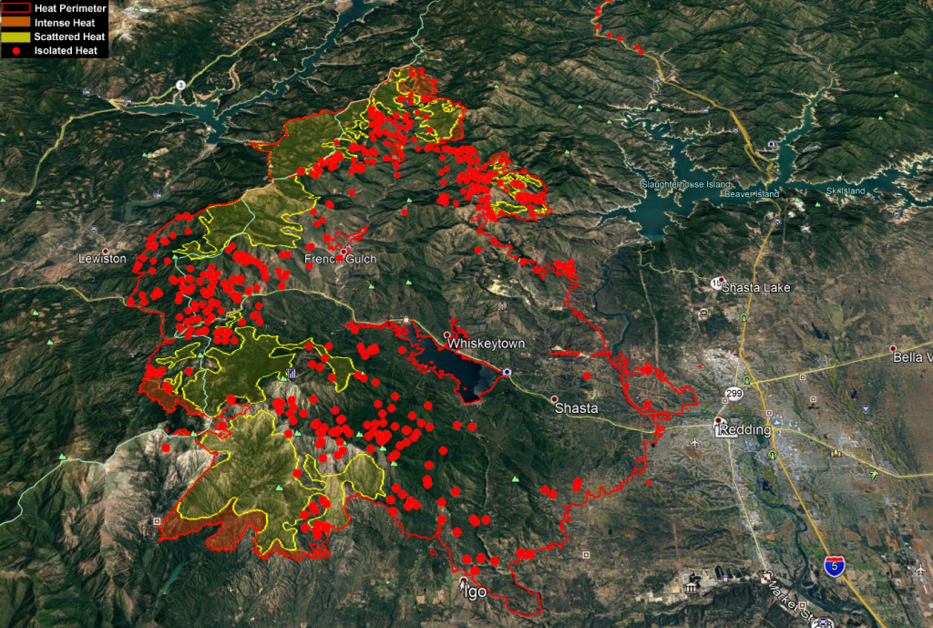
- KMZ Map–Zoom for detail or for 3D imagery, click on the map and download a file that connects with your Google Earth program.

Carr Fire Heat Map August 8
Donations:

- Stuffed Toy Drive in Eureka, Weaverville, and Willow Creek for victims. (See more information here.)
- Northcoast Horticulture Supply is working with Pay It Forward Humboldt to collect donations for the Carr fire.
McKinleyville 1580 Nursery Way
Arcata 639 6th St
Eureka 852 W Wabash Ave
Fortuna 126 Dinsmore Dr
Note: “Pay It Forward Humboldt has asked us to collect gift cards and N95 respiratory masks only at this time. We’ve tried to be specific about what’s needed at this point in time in our social media because folks tend to drop off random and sometimes heavy items that are not useful until folks can set up temporary housing. Once they have the donation centers set up over the next days/weeks, they will be accepting clothes, household donations and larger items.”
Resources:
Redwood Acres Fairground is accepting evacuees for free camping.
Earlier Chapters:
- Fire Near Whiskeytown Closes Hwy 299
- Carr Fire: Map, Detour for 299 Closure, etc.
- Carr Fire Reaches 4500 Acres; 299 Still Closed (Maps, Photos)
- Hwy 36 to Completely Open Today and Tomorrow to Help Ease Travel Issues After Carr Fire Closed 299
- Expect Smokier Conditions in Northern California, Says Weather Service
- Carr Fire Jumps Sacramento River; Western Redding Being Evacuated
- Two Dead and Thousands Displaced as Carr Fire Tears Into Redding
- Images From the Carr Fire and the Smouldering Devastation Left Behind It
- The Carr Fire: Almost 90,000 Acres Burned [Photos, Maps, Video]
- Carr Fire Pushes Into Trinity County; Evacuations
- The Carr Fire Switches Attack: Some Redding Area Residents Allowed to Return Home; But Trinity County Residents on Edge as It Turns on Them
- Carr Fire Threatens Trinity County and Communities to the Southwest of Redding
- The Carr Fire Glares Down Into Trinity County as It Continues to Grow [Maps Included]
- The Carr Fire: 131,896 Acres and Growing [Maps]
- Another Dead as the Carr Fire Grows (Maps)
- Operations Map –to see details either zoom or click on the map and download a pdf.
- Progression map up till yesterday–


Join the discussion! For rules visit: https://kymkemp.com/commenting-rules
Comments system how-to: https://wpdiscuz.com/community/postid/10599/
testing… banned 1st amendment speaker here….?
God bless the firefighters.
Kym, this was put together beautifully…Thank you.