
[UPDATE 2:45 p.m.] Carr Fire Threatens Trinity County and Communities to the Southwest of Redding
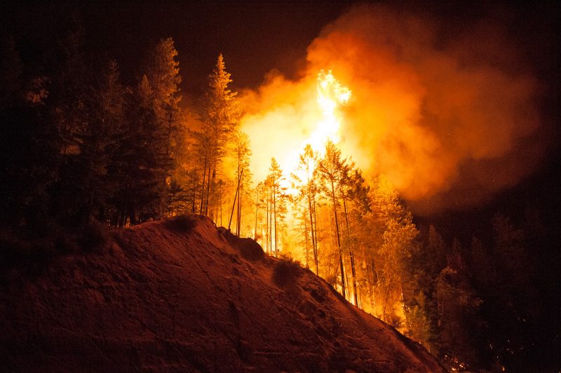
Trees burn on the side of 299 near Whiskeytown Lake.
The Carr Fire continues to expand reaching 110,154 acres but it is now 27% contained. Almost 16,000 people are still evacuated even though some residents have been allowed to return home.
The communities of Lewiston, Igo, Ono, and Gas Point face ongoing threats, according to the Northern California Geographic Coordination Center (ONCC). “884 residences and 347 outbuildings have been destroyed, 169 residences have been damaged and damage assessment is ongoing.”
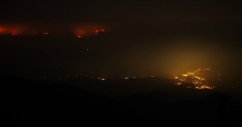
The Carr Fire looms ominously on the hills east of Weaverville. [Crop of a photo by Jed Medin from Weaver Bally]
For the latest on evacuations and road closures, click here.
The Plan:
With the continued push to the west, firefighters will be paying particular attention to the County Line Road area where the Carr fire has slopped over in several places. The worst area is east of the Pappoose arm of Trinity Lake. Firefighters will be watching on the west side of the fire for spot fires in multiple directions.
The Carr might also push to the north where there is a great deal of timber. Trees catching fire, creating 100-foot tall torches that send embers and flames flying could create spot fires.
The Weather:
The smoke inversion is expected to continue which somewhat cools the area but the weather is still going to be hot, hot, hot and dry. Cal Fire said, “The atmosphere remains primed for unstable conditions…” They also are concerned that a plume could develop, then the fire can develop its own weather including whirlwinds.
Northwest winds are expected to kick in this evening.
Scenes from the Carr Fire from Mark McKenna:

A deer crosses Harlan Drive in the Lake Redding Estates subdivision in Redding.

A Sikorsky helicopter prepares to fill up with fire retardant from tanks on the field of Igo, Ono, Platina Elementary School south Redding.
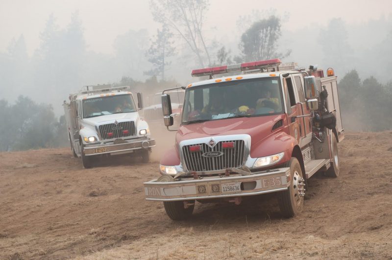
A Cal Fire Strike Team leaves a safety area and heads to fight the Carr Fire.

A Sikorsky helicopter prepares to fill up with fire retardant from tanks on the field of Igo, Ono, Platina Elementary School south Redding.

Crews work to mix fire retardant for helicopter battling the car fire near the town of Igo.
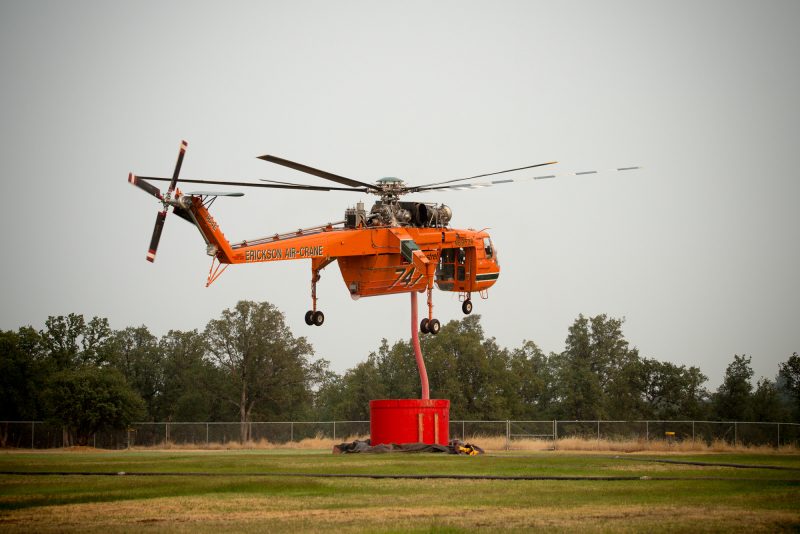
A Sikorsky helicopter fills up with fire retardant from tanks on the field of Igo, Ono, Platina Elementary School south Redding.
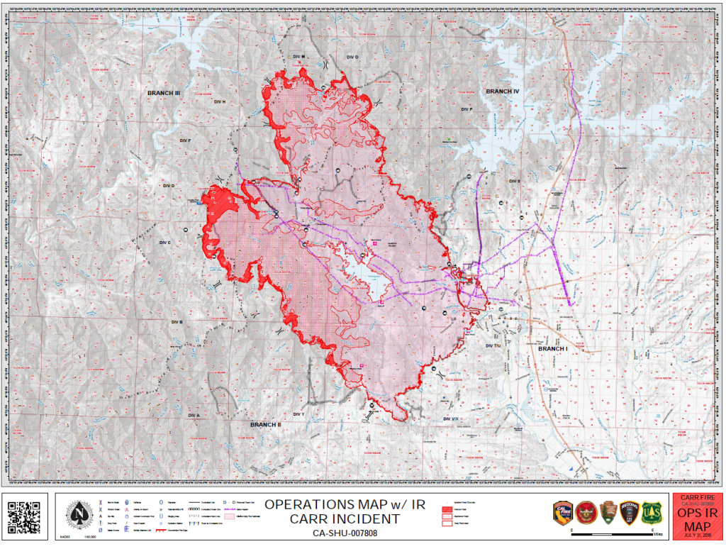
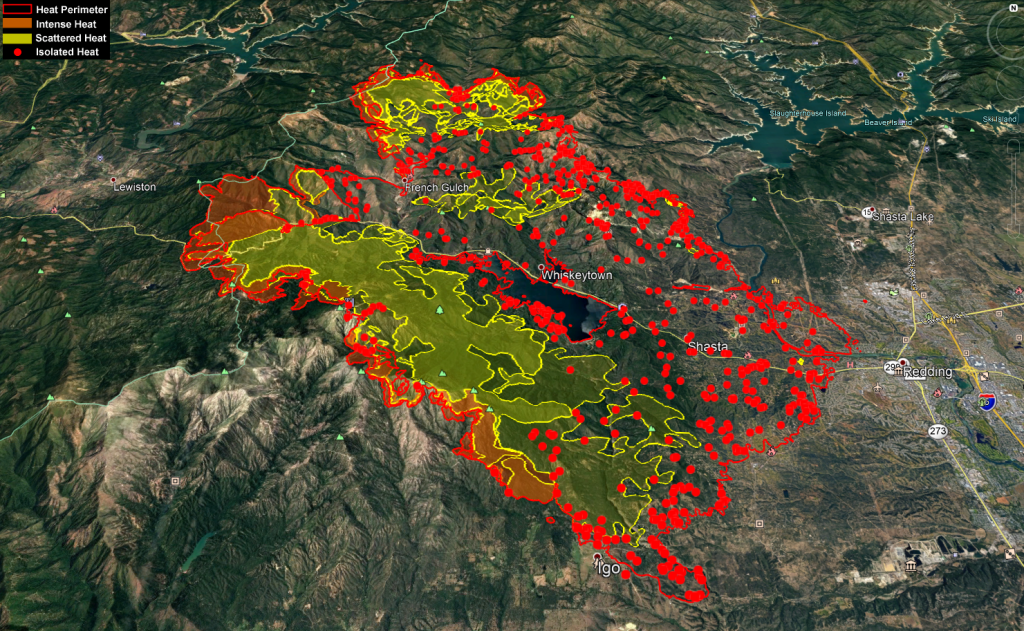
The MAPS:
- Operations Map –to see details either zoom or click on the map and download a pdf.

- KMZ Map–Zoom for detail or for 3D imagery, click on the map and download a file that connects with your Google Earth program.

Carr Fire heat map.
Donations:
- Northcoast Horticulture Supply is working with Pay It Forward Humboldt to collect donations for the Carr fire.
McKinleyville 1580 Nursery Way
Arcata 639 6th St
Eureka 852 W Wabash Ave
Fortuna 126 Dinsmore Dr
Note: “Pay It Forward Humboldt has asked us to collect gift cards and N95 respiratory masks only at this time. We’ve tried to be specific about what’s needed at this point in time in our social media because folks tend to drop off random and sometimes heavy items that are not useful until folks can set up temporary housing. Once they have the donation centers set up over the next days/weeks, they will be accepting clothes, household donations and larger items.”
UPDATE 2:45 p.m.: Cal Fire reports,
- Evacuation orders have been lifted and residents may return home in the following areas:
River Park Highlands Subdivision
For residents returning home to River Park Highland Subdivision, use
Benton Drive to access River Park Drive.
*The road will remain closed at Quartz Hill and Terra Nova Drive. - Evacuation orders have been lifted and residents may return home in the
following areas
The communities of Summit City and Buckeye to include the following
areas listed below:
Lake Blvd north of Oasis Road to the Shasta Dam
Pine Grove Ave. west from Iron Horse Road to Lake Blvd.
Walker Mine Road to the overhead powerlines. All residences on Walker
Mine Road west of the overhead powerlines remain under mandatory
evacuations.
Quartz Hill road from Lake Blvd. just west of Counter Lane will be open. A closure will be in effect at Quartz Hill Road west of Counter Lane. All
residences west of this closure point will remain under mandatory
evacuations.
The public is asked to limit traffic in these areas to residents only. - Evacuation orders have been lifted in the Happy Valley area. However,
mandatory evacuations are still in effect for the communities of Igo & Ono.
***Road closures will be at the intersections of; Placer Road and Platina
Road, Clear Creek Road and Cloverdale Road. Gas Point Road will
remain open to through traffic. All areas west on Platina Road and north
on Placer Road will remain under mandatory evacuation.
Earlier Chapters:
- Fire Near Whiskeytown Closes Hwy 299
- Carr Fire: Map, Detour for 299 Closure, etc.
- Carr Fire Reaches 4500 Acres; 299 Still Closed (Maps, Photos)
- Hwy 36 to Completely Open Today and Tomorrow to Help Ease Travel Issues After Carr Fire Closed 299
- Expect Smokier Conditions in Northern California, Says Weather Service
- Carr Fire Jumps Sacramento River; Western Redding Being Evacuated
- Two Dead and Thousands Displaced as Carr Fire Tears Into Redding
- Images From the Carr Fire and the Smouldering Devastation Left Behind It
- The Carr Fire: Almost 90,000 Acres Burned [Photos, Maps, Video]
- Carr Fire Pushes Into Trinity County; Evacuations
- The Carr Fire Switches Attack: Some Redding Area Residents Allowed to Return Home; But Trinity County Residents on Edge as It Turns on Them
Join the discussion! For rules visit: https://kymkemp.com/commenting-rules
Comments system how-to: https://wpdiscuz.com/community/postid/10599/
Thank you Kym.
Thanks Kym
I was wondering if anyone can tell me what is in the fire retardant mix? A huge thank you to all firefighters, first responders and all folks who are working on all of the fires around us! And, thank you Kym, so much! You are the first sight I look at every morning on the computer. You are da woman!!
https://en.m.wikipedia.org/wiki/Fire_retardant
“Some of the main components of Phos-Chek retardants include ammonium polyphosphate, diammonium phosphate, diammonium sulfate, monoammonium phosphate, attapulgus clay, guar gum (or a derivative of guar gum), and trade secret performance additives.[11][12] Fire retardants are manufactured as several different formulations with varying proportions of the above components.[13]”
https://en.m.wikipedia.org/wiki/Phos-Chek
You seem pretty informed, how’d this fire start? Anyone know?
https://www.redding.com/story/news/2018/07/31/carr-fire-update-what-we-know-tuesday/869848002/
Scroll down to the noon update for more info on that.
A tire popped on a trailer and sparks went flying.
Thank you Kym and thank you to all the firefighters and support people. Pay it Forward Humboldt is also collecting N95 masks and gift cards at these locations.
Root 101 Nursery, 350 Sprowel Creek Road, Garberville. 707-219-0009
Root 101 Nursery, 770 Wildwood Ave, Rio Dell. (707) 506-3071
Is hay fork going to be safe?
From this fire, yes.
Thank you ,for letting me now,cause it sure is scary with all the smoke here,Im born & raised humboldt,but only moved to trinity a few months ago,and it is like different kinda planets for each other for sure. I SEE LOCOLS ALL COM. AND EVERY YEAR FIRES BRAKE OUT,BUT IM LIKE FREAKY OUT NOT IN HUMBOLDT,WAY WET AND FOGGY,GLUMMY.
Help firefighters, help yourself.
Many FD’s suggest against roof sprinklers simply because it takes water away from them. So store the water beforehand, the more the better.
Don’t rely on city electric to be on in emergencies either; use a gas pump.
Thanks Kim. My heart goes out to all affected communities. I have a friend whose family lives in Lewiston. Thank you fire personal, water tenders, charitable donations, people who are evacuated and enabling our professionals to do their jobs. And last but not least, thank you everyone that cares. We are a large community, it takes more than just a village to take care of our loved ones.
Calfire map cataloging damaged and destroyed structures.
https://calfire-forestry.maps.arcgis.com/apps/PublicInformation/index.html?appid=5bbcbed430ad45e5a38e6be155ef5fec
“Carr Fire – Structure Status Information
Field damage inspection is still ongoing and subject to change. The points shown in this map are being updated regularly. Data is subject to change as information is gathered and verified. The icons on the map indicate the current known status of the structure.
Addresses may be entered into search bar to find a specific location.”
And PLEASE, leave water and food for the animals as you can. They are losing their homes as well!
How much water can the silo helicopters take/hold/carry?
KMZ map using Google Earth is incredible. Thanks a lot!
New fire near Covelo in Mendo! 800+acres.
Mendovoice.com
The Eel Fire
Thank you so much for saving my house i. Ever knew how important my house was to me i didnt have time to evacuate it was so scary it just wiped into redding so fast i didnt have time. So thankful
Thank u so much for saving my house the fir was so close it was in my backyard and front so scary thanks.