
[UPDATE 8:25 a.m.: One of the Dead Is a Redding City Firefighter] Two Dead and Thousands Displaced as Carr Fire Tears Into Redding

Building on fire off Hwy 299 on Buell Alley in the town of Shasta yesterday afternoon. [Photo by Mark McKenna]

Smoke billowing from the Carr Fire over Whiskeytown Lake yesterday afternoon. [Photo by Mark McKenna]
The fire has been throwing embers and spotting up to one mile ahead so firefighters will be watching for that today also. The conditions in the early evenings of the last few days have fed the fire and firefighters will be looking for more of the same starting around 5 p.m.
For more on the latest evacuations and road closures, go here.
Maps:
- Operations Map –to see details either zoom or click on the map and download a pdf.

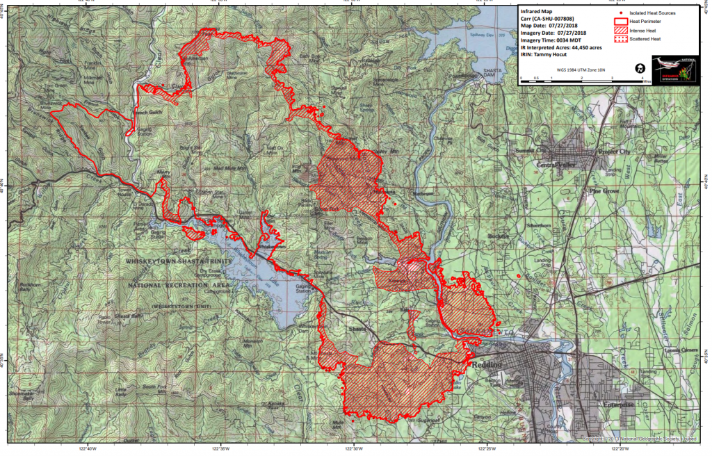
Operations Map Carr Fire compiled about 1:30 a.m.
- Heat Map–to see details either zoom or click on the map and download a pdf.

Heat map of the Carr Fire created from imagery taken just after midnight.
- KMZ Map–Zoom for detail or for 3D imagery, click on the map and download a file that connects with your Google Earth program.

Heat imagery over Google Earth map compiled a little after midnight.


UPDATE 8:25 a.m.: According to a Cal Fire spokesperson, there were two fatalities. One was a “private hired dozer operator” yesterday afternoon. The other death was “a Redding city firefighter.” The spokesperson wasn’t able to provide information about where the deaths occurred nor about their circumstances. He did say, “The families are being notified. We are still in the fact-gathering portion of the incident.”
In addition, he said that there were “three minor injuries to firefighters and some reports of minor injuries to civilians but we do not have a count.”
UPDATE: Images From the Carr Fire and the Smouldering Devastation Left Behind It
Earlier Chapters:
- Fire Near Whiskeytown Closes Hwy 299
- Carr Fire: Map, Detour for 299 Closure, etc.
- Carr Fire Reaches 4500 Acres; 299 Still Closed (Maps, Photos)
- Hwy 36 to Completely Open Today and Tomorrow to Help Ease Travel Issues After Carr Fire Closed 299
- Expect Smokier Conditions in Northern California, Says Weather Service
- Carr Fire Jumps Sacramento River; Western Redding Being Evacuated
- Two Dead and Thousands Displaced as Carr Fire Tears Into Redding
Join the discussion! For rules visit: https://kymkemp.com/commenting-rules
Comments system how-to: https://wpdiscuz.com/community/postid/10599/
Thank you. Kym, your reporting is clear, concise and useful. Such a horrifying situation.
Thanks for the great reporting and photos! Mark, great job, please stay safe!
Thank you Kym.
Hey Kym, do you know if our power around Humboldt Bay is routed through redding?
No it is not
We need to drive from Arcata to Chico two days from now. Any advice from readers on which route to take? (299 to 3 to 36 vs. straight 36)
I would stay off 299 and 3 completely…too close to fire and personnel . Take 36 or the long way 20
I’d take 36 the whole way.
I’d rather walk than take hwy 36. We always take hwy 20 through Clear Lake. Its a much easier drive.
I would totally avoid the 299 and 3. I drove from Eureka to Redding yesterday and back on the 36. There was a lot of smoke and ash as you entered Redding from the South. The 36 was closed from 8-12 in the construction zone, so we had to wait in a long line of traffic until noon. I’m glad CalTrans decided to open up the 36 later in the day. According to a local we met waiting on the road, the 36 has been closed for a year except for a few hours a day. Not only does it seem a little extreme to deal with everyday, it did not make since that the road wasn’t open when there is a massive fire and the 299 closed, which obviously effects travelers but more importantly people fleeing the fire or trying to get to their property or fight the fire! I saw a lot of heavy equipment coming from Redding on the 36 and then using the 3 to get to the fire.
Take 20. Its It’s way better.
Due to people needing Hwy. 36 because of the fire it is open 24 hours a day now. Construction is halted until the emergency is over…
We need to get air masks from Redway up to Eureka today to get over to Redding. Who can help? Please check our Pay it Forward Humboldt facebook page to help, or let me know. Thanks!
Call some of the businesses who do that route; rendezvous vending comes to mind or beer dristrubutors
Looks like we’ve got them already. Thanks SoHum!
Did you find anyone? I can help I’m going that way today from loleta.
The only safe masks with wildland fire smoke are n95 or n100 masks. Plain dust masks only break particles smaller and they lodge deeper into the lungs. This is why you don’t see wildland firefighters wearing masks..no one has come up with a safe one that filters properly and doesnt cause heat exhaustion or reduce oxygen intake…
We can’t thank you enough for your excellent coverage of the Carr fire.
I am deeply saddened to learn that two firefighters have lost their lives trying to stop this monster. Very sorry also for the people who have lost homes. I pray everyone will stay safe and no more lives will be lost. God bless.
To get help to the folks in Redding and the surrounding area, check in with the Pay it Forward Humboldt FB group. Things like air masks are needed immediately, especially for the young, elderly and those with respiratory problems.
Yet another terrifying fire. My thoughts and prayers go out to the loved ones of the brave fire fighters and the citizens of Redding.
Great reporting.
Nature bites back. All those subdivisions and overbuilding (and hoarding, as seen by the first picture). People running for their lives is a terrible thing. The wild being exploited, just as bad.
This is just so terrifying and sad! God bless our firefighters & first responders, also the people affected. We all need to be very, very cautious as this could be us. One carelessly tossed ciggy butt, campfire, glass bottle, hot muffler in dry grass or vehicle dragging chain are but a few causes. Please pay attention to what you are doing folks & the consequences of your actions!!
44,000 acres…Jesus. Anyone know roughly how many miles that’s is?
Is there a precedent of having 2 wildfires, in less than a year, burn into (medium+) size cities in CA?
Between this one and the one in Santa Rosa, these are great losses!
1871 produced at least 3 wild fires that burned into and through several cities in Michigan and Wisconsin. They were driven by the same things as here- high temperatures and wind.
global warming and weather pattern shifts meet overgrown saddle tanning and doug fir plantations… people need to start viewing northwest ca as a desert with lots of tanoak plantation trees littering the landscape, sadly. That’s becoming the sad truth of it. Firebreaks and “tree removal” make lots of sense… preventative maintanence needed…
Yes Kym, thank you for great reporting! Glad there is a Reheaded Blackbelt!
Farming drawing water to farms and sea is causing desertification.Cadillac Desert.salination in California.
I am reading Cadillac Desert now. An excellent old classic about California’s water history. Recommend it. A sadly compelling page-turner.