
31 Confirmed Dead in Wildfires That Broke Out Earlier This Week: Maps

Yesterday afternoon on the Redwood Fire at 5:30 PM looking north from Gibson Lane. [Photo by Hannah Foster]
Higher winds and continuing dry weather are predicted for later today which could cause dangerous conditions for spreading the current flames or fan sparks into new wildfires.
8,000 firefighters are on the ground as part of the battle Cal Fire is spearheading against the current blazes.

Looking north in Potter Valley on October 11. [Photo by Hannah Foster]
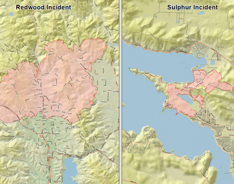
According to Cal Fire, “Firefighters utilized favorable weather conditions, across both fires, to their advantage yesterday and throughout the night towards achieving containment and providing structure defense, however, the fire continues to burn in multiple directions threatening numerous communities and infrastructure. Steep inaccessible terrain coupled with critical fuel moistures, and northwest winds will provide challenges for crews working on the fire. 34,000 acres have burned in the Redwood Fire, 10% contained. 2,500 acres have burned in the Sulphur Fire, 55% contained. There have been 8 fatalities and approximately 8000 people have evacuated throughout the incident.”
Here’s Cal Fire’s morning fact sheet:
10-13-17 AM Fact Sheet (1)MAPS:

[Photo by Michael Godinez]
Below are the most recent maps available as of 8 a.m. Friday morning. (Timestamps of when the information was collected that was used to create the maps can usually be found in the corners of the PDF’s).
Click on the thumbnail images of each map to be taken to a pdf. Usually, in the lower right-hand corner of each expanded map, you can see the time and date that the information to create each map was collected.
The Mendocino/Lake Complex:
Mendocino/Lake Complex map
We also have a KMZ file that can be viewed in Google Earth if you have access: 20171013_0214_MendocinoLakesComplex_CAMEU012169
The Central LNU Complex in Sonoma:

Tubbs and Nuns Fire map
We also have a KMZ file of the entire Central LNU Complex which includes the Tubbs Fire in Santa Rosa that can be viewed in Google Earth if you have access: 20171013_CentralLNUComplex_IR
The Southern LNU Complex in Napa County:

Southern LNU Complex
We also have a KMZ file of the entire Southern LNU Complex which includes the Atlas Fire that can be viewed in Google Earth if you have access:20171013_Atlas_IR (1)
More Information in Related Stories From Earliest story at the top to the Most Recent at the Bottom:
- Major Fires Breaking Out in Northern California: Structures and Vehicles Burning, Evacuations Ongoing, Victims Injured, Roads Closed
- Major Fire in Mendocino Joins Others Whipping Across Northern California; 101 Closing
- Redwood Valley North of Ukiah on Fire: Evacuations, Multiple Structures Burned, Serious Injuries
- Potter Fire: 1500 Acres, 11 Structures Confirmed Destroyed
- TV and Phone Services Down on the West Coast
- Fire Hits Just Above the Belt: Overview of the Fires Burning From Mendocino to Sonoma
- One Dead, Multiple Structures Burned, Numerous Injuries, One Looter Arrested in Redwood Complex Fire
- Mendocino Sheriff Declares State of Emergency, Approximately 10,000 Acres Burned, 0% Containment, Approximately 80 Structures Gone
- Evacuation Information (Including Map) for the Redwood Complex in Mendocino
- Redwood Complex Fire: 19,000 Acres, 0% Contained
- Good News! Hwy 101 Reopens Between Ukiah and Willits
- Detailed Fire Maps of the Redwood Complex, the Sulpher Fire, the Central LNU Complex, and the Southern LNU Complex
- Third Confirmed Death in Redwood Complex; Now at 21,000 Acres and Still 0% Containment
- Smoke Impacts the Emerald Counties
- New Evacuation Today, Willits Meeting, New Temp Cell Tower for Willits
- Humboldt County and City Offices Reporting Issues With Phones and Access to Data
- 259 Homes Destroyed and 800 Structures Threatened in Mendocino and Lake County Fires Combined
- Maps of the Mendocino, Lake, Sonoma, and Napa County Fires
- Smoke from Mendocino Lake Complex, Santa Rosa Area Fires May Continue to Affect SoHum
- PG&E Assessing Damage from Mendocino Lake Complex Fire
- AT&T Disaster Response Teams Deployed to Areas Impacted by Wildfires
- Humboldt Food Bank Sending Food to Santa Rosa to Help with Fire Relief
- EPD Wants Your Help Filling This Trailer With Donations for Fire Victims in Mendocino County
- Additional Evacuation Warnings, Mandatory Evacuations Now in Place in Potter Valley Due to Redwood Fire
- 23 Dead, 3,500 Structures Destroyed, 20,000+People Evacuated: Maps of Mendocino, Lake, Sonoma, and Napa County Fires
- 8 Confirmed Dead in Mendocino Lake Complex, More Fatalities Expected, Dangerous Fire Conditions Starting Tomorrow
Join the discussion! For rules visit: https://kymkemp.com/commenting-rules
Comments system how-to: https://wpdiscuz.com/community/postid/10599/
Again I appreciate the information. However sad it makes me.
Great coverage!
my kids dads house is in the 12000 block of tomki rd. in redwood valley.
does anyone know if structures have burned there?
i have not heard anything back from anyone,
and hope every day for some good news.
thank you kym for your informative website.
I have Google Earth but can’t seem to open the image for the MendoLakesComplex fire. Any advice?
It should be fixed now. I’m not sure what went wrong.
Thank you kym!!!!!!
Please everyone be extra super duper careful over the next few days with anything that can spark. If you see someone using a power tool or having a burn pile (some folks just dont get it), dont hesitate to stop and remind them of the fire danger.
One of the best gifts we can give our neighbors to the south is to keep our area fire free to the best of our ability and not pull any emergency services away.
Thank you Kym!
I noticed the map today for the redwood fire looks exactly the same as the google earth map from 10/11, even on the north side and in the mountainous terrain. I spent some time comparing details. Either they have the fire pretty darn under control for now, including in difficult terrain, or they are recycling info. ???
Maybe they are saving their time & energy to remap after the winds pick up? Do you know if the images are generated by satellite or by plane?
There’s a difference that you can see best on the KMZ from yesterday and today. I circled the area that you should look in white.
Thanks Kym, then I guess it’s pretty stabilized for now. I looked at the wind forecasts for that area and they’re forecast to be less than before. I might go down there this weekend if I’m able to.
People say they are just doing mop up and spot checking in the reeves canyon area. I have friends in that area. If they’re letting people back in Redwood Valley that might be the case there as well. I’m wondering about PV though.