
Maps of the Mendocino, Lake, Sonoma, and Napa County Fires

Mendocino residents fighting fire in the early hours of October 9.[Original photo by Michael Godinez]
Below are Cal Fire maps of most of the incidents. These are the most recent maps available as of 8:30 a.m. Wednesday morning. (Timestamps of when the information was collected that was used to create the maps can usually be found in the corners of the PDF’s).
Located at the bottom of this post are thumbnails of the detailed PDF maps. In order to see the PDF’s full size, click the thumbnail and the PDF will open in your browser (assuming your computer hasn’t blocked popups from opening). It may take a few seconds for the maps to load, so give it some time.
Click on the thumbnail images of each map to be taken to a pdf. Usually, in the lower right-hand corner of each expanded map, you can see the time and date that the information to create each map was collected.
The Mendocino/Lake Complex:
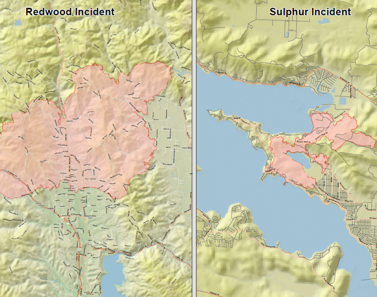
Mendocino/Lake Complex map
We also have a KMZ file that can be viewed in Google Earth if you have access: 20171011_MendicinoLakesComplex_IR . In addition, here is a pdf map of the Sulfur Fire:
20171011_MendicinoLakesComplex_IR_TopoMapSulpher_11x17Here is a pdf map of the Redwood Complex Fire:
20171011_MendicinoLakesComplex_IR_TopoMapRedwoodIncident_11x17The Central LNU Complex in Sonoma:

Tubbs Fire map
We also have a KMZ file of the entire Central LNU Complex which includes the Tubbs Fire in Santa Rosa that can be viewed in Google Earth if you have access: 20171011_CentralLNUComplex_IR
The Southern LNU Complex in Napa County:

Southern LNU Complex
We also have a KMZ file of the entire Southern LNU Complex which includes the Atlas Fire that can be viewed in Google Earth if you have access: 20171011_SouthLNU_IR
More Information in Related Stories From Earliest story at the top to the Most Recent at the Bottom:
- Major Fires Breaking Out in Northern California: Structures and Vehicles Burning, Evacuations Ongoing, Victims Injured, Roads Closed
- Major Fire in Mendocino Joins Others Whipping Across Northern California; 101 Closing
- Redwood Valley North of Ukiah on Fire: Evacuations, Multiple Structures Burned, Serious Injuries
- Potter Fire: 1500 Acres, 11 Structures Confirmed Destroyed
- TV and Phone Services Down on the West Coast
- Fire Hits Just Above the Belt: Overview of the Fires Burning From Mendocino to Sonoma
- One Dead, Multiple Structures Burned, Numerous Injuries, One Looter Arrested in Redwood Complex Fire
- Mendocino Sheriff Declares State of Emergency, Approximately 10,000 Acres Burned, 0% Containment, Approximately 80 Structures Gone
- Evacuation Information (Including Map) for the Redwood Complex in Mendocino
- Redwood Complex Fire: 19,000 Acres, 0% Contained
- Good News! Hwy 101 Reopens Between Ukiah and Willits
- Detailed Fire Maps of the Redwood Complex, the Sulpher Fire, the Central LNU Complex, and the Southern LNU Complex
- Third Confirmed Death in Redwood Complex; Now at 21,000 Acres and Still 0% Containment
- Smoke Impacts the Emerald Counties
- New Evacuation Today, Willits Meeting, New Temp Cell Tower for Willits
- Humboldt County and City Offices Reporting Issues With Phones and Access to Data
- 259 Homes Destroyed and 800 Structures Threatened in Mendocino and Lake County Fires Combined
Join the discussion! For rules visit: https://kymkemp.com/commenting-rules
Comments system how-to: https://wpdiscuz.com/community/postid/10599/
thank you for keeping us up to date. You provide an important resource.
Here is a link to CA fire map to pinpoint existing fire perimeters. I was able to pinpoint down to an exact address. This map was updated at 7:58am 10/11: http://www.fire.ca.gov/current_incidents/incidentdetails/Index/1874
Hi Kym – Thanks for the helpful mapping. Two questions: On the external map link from fire.ca.gov that goes to a google map, I cannot find anything about update times. Where should I be looking?
Also, in the Press Demo this morning they had a map that shows a fire west of Cloverdale in the Lake Sonoma region creeping over the Sonoma County line into Mendo County. I have friends that live a few miles north of there but I cannot get any additional info about that fire. It is not a listed fire on CalFire. This is not a welfare check, I know they are all right, but they will want info on this fire. Suggestions?
If it is not in the CA State Responsibility area (eg. federal land) it will not be listed at http://www.fire.ca.gov. Check https://inciweb.nwcg.gov/ search by state for CA fires.
THANK ALL THE MEN AND WOMEN,who risk their lives fighting these devastating wild fires. Please take care and THANK YOU God Bless you all. I’m praying for everyone who hasn’t been heard from, and everyone injured.🕆🙏🙏🙏
not a good time for cal exit and sanctuary cities let alone proclaiming a sanctuary state,…
brown face wants to declare a state of emergency to whom exactly?
the other 49 states are fed up with cali bullshit and could care less to send help or money out west.
time for californians to figure out what side they are on
Definitely not on yours!
That face is priceless.
Thankyou.
Pray for the firefighters.
Gov. brown should be fired, he could have planes out dropping fire retardant and tankers out there with water; have that fire out tomorrow. There is plenty of water, El Niño stopped the drought. He must be saving it all for his greedy cronies. Worst gov. ever.
Not so fast Andrew…fixed wing planes can NOT FLY IN THICK SMOKE, so your misguided comments are not only WAY wrong, your “person bashing” (GovBrown) makes you look very foolish…grow up…
Ya think these fire can be put out in ONE DAY..? Here is a shovel & Nomex fire suit, go to it…
Kym, thank you for your awesome coverage of fire and all Sohum news. Can you post what donations are needed for fire victims, and where we can drop off?
Check this: https://kymkemp.com/2017/10/11/epd-wants-your-help-filling-this-trailer-with-donations-for-fire-victims-in-mendocino-county/
And This: https://kymkemp.com/2017/10/11/humboldt-food-bank-sending-food-to-santa-rosa-to-help-with-fire-relief/
My old hometown Calistoga (Upper Napa Valley) is being evacuated…entire town…
My friend in Middletown thinks this might be an over reaction, but winds are pushing the fire down from Bennett Road towards town…at first evac order was for Grant St & north end of town…now entire town ordered to leave (Napa County Fairgrounds at Calistoga was an evacuation center)…
AND there are fires in the southern end of the NAPA VALLEY…Options will be limited for residents of Calistoga as to where to go…
Calistoga still has large iron fire shutters (typical of Gold Rush towns) on the rear of the old Wells Fargo building
Here’s the link to the calfire incident map. Brings up a google map that can be zoomed in and out. We are the Redwood Valley fire. The Calistoga – Santa Rosa area is the Tubbs Fire. Clearlake/Clearlake Oaks in Lake County is the Sulphur Fire. https://www.google.com/maps/d/u/0/viewer?ll=39.26270594772597%2C-123.23704742605594&hl=en&z=15&source=embed&ie=UTF8&mid=1TOEFA857tOVxtewW1DH6neG1Sm0&output=embed