
[UPDATE 9:47 p.m. Hwy 53 Reopened] Maps of the Clayton Fire, Thousands Evacuated, Likely Hundreds of Structures Destroyed
Are you wanting to know where the Clayton Fire burned so far? The latest maps are below.
But first a quick recap, the Clayton Fire tore through the town of Lower Lake yesterday after flames burst through contingency lines and raced into an area which had remained unscathed during last year’s devastating fires. (See previous story here.)Thousands evacuated by car, bus, and even sometimes by walking. Animals and people fled from flames that appear to have destroyed more than 100 homes and businesses (Cal Fire will be bringing in a team today to access the damage.) We’ll be updating throughout the day as the fire continues to push across drought parched lands.
Below we posted a screenshot taken from a heat map of the fire. (You can download the large version for a 3D-type experience if you have Google Earth installed by clicking this link. This allows you to inspect the areas within the fire closely. Please give it some time to download.)
 Note the intense heat on the northeastern edge of the fire. As well as the scattered red dots showing pockets of heat.
Below we also have a topo map. Too small, right? Don’t worry. Just click on it and wait for a pdf map of the area to load. [Both of these maps were based on heat radiation imagery taken at 1:47 a.m.]
We will be updating as new information comes in.
UPDATE 8:52 a.m.: Let people know that lost and found pets can be reported at this site here.
UPDATE 9:07 a.m.: Follow Matthew Henderson for photos and updates from the frontlines.
UPDATE 9:55 a.m.: Cal Fire just released this updated map showing the Clayton Fire in relation to the 2015 fires.
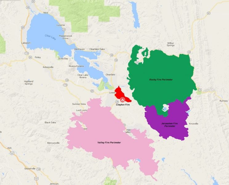
Cal Fire map of Clayton Fire in relation to 2015 fires as of August 15, 2016
UPDATE 10 a.m.: Firefighters will be looking to use the perimeter lines from the 2015 Rocky Fire to stop the Clayton Fire from spreading. At this point, there are multiple aircraft and crews working the fire using daylight to their advantage before the sun sears the vegetation and makes it more likely to ignite.
UPDATE 10:06 a.m.: Caltrans has an update on the roads. We’ve embedded it from their Facebook page.
UPDATE 12:01 p.m.: A falling tree killed a hotshot working on the Strawberry Fire, yesterday. This is not the same fire as the one in Clearlake but we thought we should honor the one who died here. This was sent out yesterday.
At approximately 1600 hours, a Lolo Interagency Hotshot crew member [Justin Beebe of Bellows Falls, Vermont. He is a member of the Lolo Hotshots based in Region 1] with the US Forest Service. was hit by a falling tree, sustaining critical injuries. Line EMTs and paramedics assigned to the division responded and a short haul capable helicopter was launched. A short-haul extraction was initiated at 1730 and the injured firefighter was transported to helibase. Life Flight paramedics, in consultation with a physician in Ely, declared the firefighter deceased at 1746.
A Coordinated Response Protocol (CRP) Team and Learning Review Team (LRT) has been mobilized and will receive an in-briefing and delegation of authority at 1800 hours today.
//s// Steve Mietz
Superintendent, Great Basin National Park
The deceased is Justin Beebe of Bellows Falls, Vermont. He is a member of the Lolo Hotshots based in
Region 1 with the US Forest Service.
UPDATE 12:15 p.m.: Cal Fire update stated:
- Southern Clearlake area still evacuated
- 1000 firefighters working today.
- CAL FIRE crews doing assessment of how many buildings burned today. 175 homes burned down… multiple commercial buildings
- Hwy 29 and 53 closed.
- Fire moving east today.
UPDATE 1:50 p.m.: Cal Fire says fire is
- 4000 acres
- 1500 Structures threatened
- 175 Structures Destroyed
- Over 1000 personnel on scene
UPDATE 1:51 p.m.: Lake Co. Sheriff issued the following information about donations:
Information Concerning Donations
North Coast Opportunities, Inc. (NCO) is re-activating the fire relief fund created during 2015’s devastating Lake County wildfires, and is already working with local organizations to react as quickly as possible to the Clayton fire.
More details about the fund and how to apply will be forthcoming. In the meantime, donations are being accepted at any Mendo Lake Credit Union branch, at any NCO office, or via PayPal: https://www.paypal.com/cgi-bin/webscr?cmd=_s-xclick&hosted_button_id=HLU6ZNS7EDQU8. Make checks payable to NCO / Wildfire Relief Fund, and write “Clayton Fire” in the memo section.
UPDATE 4:47 p.m.: Schools closed.
School Closures Due to Clayton Fire
For the safety of students, teachers and staff, the Konocti Unified School District schools will be closed for the week of August 15 through August 19 due to the close proximity of the Clayton Fire.
The schools affected by closure include Burns Valley Elementary, East Lake Elementary, Lower Lake Elementary, Pomo Elementary, Lower Lake High School, Lewis Center, Blue Heron School, Carlé High School, Highlands Academy, Konocti Education Center and Clearlake Creativity School.
A plan for the continuance of school operations for the following week will be released on or by Friday, August 19.
UPDATE 4:52 p.m.: Lake County Sheriff posted,
COMMUNITY MEETINGS TODAY
6:00 p.m. Kelseyville High School
7:30 p.m. Twin Pine CasinosThe public is invited to attend community meetings to be held this evening.
Community meeting #1:
6:00 p.m.
Kelseyville High School
Football field
5480 Main Street
Kelseyville, CACommunity meeting #2:
7:30 p.m.
Twin Pine Casino
South of Middletown
Middletown, CAThe goal of the community meetings is to inform the public of the current fire situation and to discuss the impact of the Clayton Fire on the community.
UPDATE 7:17 p.m.: Governor Jerry Brown proclaimed Lake County in a state of emergency “due to the effects of the Clayton Fire, which has burned thousands of acres, damaged critical infrastructure, destroyed homes and caused the evacuation of residents.”
UPDATE 7:32 p.m.: State Senator Mike McGuire tweeted,
#ClaytonFire Good News: Fire grew less than 100 acres thru out the day today. Over 1600 firefighters on scene. pic.twitter.com/IQzF7If551
— Mike McGuire (@ilike_mike) August 16, 2016
UPDATE 8:15 p.m.: Link to a video that shows the devastation of the Lower Lake Fire from above.
UPDATE 8:47 p.m.: Arrest made in the Clayton Fire. A 40-year-old Clearlake man was charged with 17 counts of arson. Read more here.
UPDATE 9:47 p.m.: Caltrans posted on their Facebook page, “State Route 53 has been reopened to traffic. Motorists should drive with caution due to fire equipment and Caltrans crews continuing inspections and tree removal.”
Join the discussion! For rules visit: https://kymkemp.com/commenting-rules
Comments system how-to: https://wpdiscuz.com/community/postid/10599/
How’s lakeport?
It’s fine
[EDIT at 11:44 a.m. Monday]: I realize that I am not going to be able to answer each question about areas affected. Please, if you have good solid knowledge try to help worried folks. I am uploading a map that might help, too.]
There is a FEMA Trailer site near LL off Hwy. 53. Was it evacuated? My brother is there after losing home last year in Cobb.
I don’t know. There was at least one trailer site evacuated but I don’t know much about it. If I find out, I’ll post here.
If in Clearlake on OLD 53, no problems.
Are the “Avenue’s” still untouched?
As of earlier this morning they were.
An easterly breeze picked up around 11am Monday, and ignited a hotspot to create a large plume. But the increased support, including a jet with retardant, made a big difference and the plume disappeared in about 45 minutes. It looks like we’ll have easterly breezes in the afternoons for the next 4 days which may(?) threaten Clearlake.
I love this kind of insight. Thank you.
My brother lives in the avenues and he said he was able to go home. That was yesterday.
My insurance company told me that Stagecoach Lane still has structures remaining on it. They could not tell me how many (or if any) had been damaged or destroyed.
Lakeport is located on the other side of the lake.
Lakeport is at the opposite end of the lake nearly 20 miles away.
Is hwy 20 flowing freely?
as of 8 am , hwy 20 open
hwy 53 closed from olympic drive south thru lower lake
Did the Walmart burn down?
fire was using walmart and rays parking lots yesterday for staging area for incoming fire crews . hope its still intact , i have shopping to do
That has got to be the most insensitive comment I have read. People’s lives are devastated and you’re greatest concern is shopping at Walmart? Grow a heart and some compassion!
He lives there and is seeing this first hand. when you’re living it, sometimes you have to laugh to keep from going crazy.
Thank you. Is this first hand, or some chp info site? May be using it tomorrow if not, 36. Hopefully I can call upon you tomo for update
as far as the fire goes , right now its not affecting hwy 20 but on that hwy anything can happen any time .
i look at both highway patrol web site and caltrans quick map on district 1 web site
How did this fire start?
There are no answers yet from Cal Fire. It might take awhile.
It took about a year to determine/release how last year’s Valley fire started… Hot tub wiring not to code.
Yep. (That report was terribly sad.)
uhhh that was not the cause
it was a pgn shed
[edit]
Uh, yes that was the official reason, released like last week. . . Hot tub wiring.
UNOFFICIAL comments on facebook saturday late afternoon had a couple fire chiefs saying arson to start clayton fire , again UNOFFICIAL as they still investigating
neighbor saw lots of fire personal FB pages saying that but still UNOFFICIAL
Under investigation
Best coverage of all the sites so far, even the P.D.
Fire is our specialty…
Sad, but extremely well done. Thank you.
Thank you.
Kym, Your integrity as a reporter is unmatched in Humboldt. Thank you!
Aww. Thank you.
Second and third that!!!
👍🏽
I second that.
Do you have any info on deer park off of morgan valley?
Kayla if someone answers you on this could you please text or call me? We live on Copsey Creek Way and are desperate to find out some news!! 707-393-7339 Julie
Hi, Julie, I have been trying to find out if the fire hit any homes in Copsey Creek subdivision, as we gave our dtr 2 lots on Deer Creek that we had. We had not built on the lots as yet, so no major loss. Someone suggested calling Cal-Fire for possible info.
https://m.facebook.com/meganberger1900
Look here, she posted video from copsey creek and many other areas.
if you know the area well ck this video as u can see a lot of aerial footage of fire area and Lower lake really well…it aeems to be really hit and miss just like valley fire but there is damage all over town. This is best footage i have seen so far
This is the best map coverage that I have found. Thank you. My sister is near Lower Lake and I worry. So many fires!
Moved out of Bay Area a couple of years ago. So sad to see this. Your coverage is excellent. I’ll keep you all in my thoughts – pray for containment, safe evacuation and return of people and their pets.
During the 2015 Lake County Fires, the following organization facilitated donations. There are doing so again:
https://www.ncoinc.org/
They are seeking monetary donations. The Social Service Director stated at the 8pm news conference on Sunday night that MONETARY donations are needed at this time. THey were inundated with inappropriate in-kind donations last year. MONEY! That’s what they need.
Does anyone know if homes were destroyed on Bryant RD?
had to look for road on map , its close to tish tang road and there was at least 1 structure reported on fire on scanner real early on tish tang . no idea about bryant . fire did not cross water channel at that area . it crossed water way out dam road .
sorry but very little i can find online as there still active fire and most reporters staying away from burning areas and its all evacuated so not many videos on FB
Heart go out to those directly effected🙏 Does anyone have word about MediaCom/ internet service? Been out since yesterday in No. Lakeport.
I read somewhere that some of their fiber optic lines were burned. My Mediacom TV (in Buckingham) has been out since 4:00pm Aug. 14. Luckily, I have DSL for internet.
Thx , I work from home so guess I’m off today.
Where is the fire in regards to Point Lakeview Road.? We have a mobile home in a park located off of Point Lakewiew Road.
About four miles east of the easternmost part of it.
MODIS Google Earth active fire mapping overlay from the Forest Service as of 9:30 this morning. Get it here:
http://activefiremaps.fs.fed.us/googleearth.php
my buddy is a volunteer firefighter on a paid Strike Team on the Clayton fire. he texted methis morning –” this place blew up. We almost got burned over.”. that wouldn’t have been good because he owes me $200, LOL.seriously, somebody made a bad decisionto put my buddies Strike Team at that much hazard.human life is the first priority. structures can always be rebuilt
And pot plants can be replanted lol.
Wind direction can change in seconds, this fire is creating it’s own weather just like valley fire which makes it extremely unpredictable. I mean how often do you see them lessen a containment %? Went from 15% to 5% containment yesterday.
Praying for rain, that those thunderstorms bring water no lightning and picturing a huge cloud burst over lake county.
Is the Riviera in dAnger?
thanks for the maps, Kym! Finally a couple of useful and helpful maps. Posted with link on Willits Weekly’s Facebook page and recommendation to follow your blog for today’s updates.
Thank you!
I have been battling with the Press-Democrat (Piss-Dimwhit?) all morning to simply publish links to your site, to donation sites, and to pet sites. THey seem incapable of doing that.
The SF Chronicle and LA Times, on the other hand, freely accept such posts.
Your journalism is WORLD-CLASS!
MUCH MUCH respect!
Why do they call it clayton fire if it’s.not in clayton c? Just curious
..it’s horrible 🙁 again!!!
It reportedly started near Clayton Creek Road on the west side of the fire.
My family home where I grew up is on Mustang Court a bunch of manufactured homes on a cul de sac. Off of Riverview Drive off Bonham don’t own it anymore but it is still home. Do you know if it is still up? Second home on left side on end, had walnut trees and a woodstove view of farmers ranch.
before the power went out yesterday i heard on scanner that some on bonham were burning in that area . that was direction fire was blowing toward out of lower lake . thats the area where fire jumped the water across dam road and started burning toward last years rocky fire . they have crews assessing damage and houses . hope by tomorrow they have up better maps like they had last years fire . i have friends in that area also and have had no contact with them . im worried also
A reporter took this video on Mustang Ct.:
https://twitter.com/EvanSernoffsky/status/764957577000030208?lang=en
There are a bunch more videos on their twitter feed from other locations in the town. I just hope everyone is alright.
My friend’s home is off Winchester on a dead end directly across from Gerry Ct. in Lower Lake. Is that area ok or not?
This link has video footage from winchester, it looks like they’ve let folks back in to see what’s left of their place.
Pretty well done videos and updates at bottom
http://m.kcra.com/news/scene-of-devestation-left-behind-by-lake-county-fire/41205670
it appears from these maps that southern Clearlake is immediately threatened.Clearlake is 10 square miles with a population of 15000. the Cal Fire report from this morning says they have only 6 aerial tankers and only a few helicopterson this fire.. it makes no sense to me that there is not more air support
my place was destroyed by the Butte fire in the Sierra Foothills 11 months ago.in my opinion there are far too few tankers in the airas the fire rapidly grew
Cal Fire boots on the ground are great. my daughter is a firefighter with Cal Fire. But questions have to be asked whenCommand Decisionsdo not seem to make sense. that’s not playing the blame game
it’s just asking for better decisions
Thank you for posting this., its been hell guessing and wondering. I left my house on Copsey Creek at 10am, found out the town burned down at 4pm…these maps are the first indication that everything is gone.
Remember not everything within the fire perimeters is gone. I haven’t seen anything on Copsey Creek yet. If I do, I’ll try and post it in reply to this comment.
We live on Copsey Creek too! I can’t see the map very well on my phone…our house has all the mailboxes in front and we recently landscaped. Do you live nearby and what could you see on the maps? We are desperate for information. …please text or call me at 707-393-7339 Julie or Ken
Julie, the maps just show the areas burned but don’t show the individual homes. I’m sorry. I don’t have any answers for you.
https://m.facebook.com/meganberger1900
Look here
Did any of the schools burn down?
School superintendent, operations guy and one of the principals let in and checking now. As of yesterday it was posted that the buildings were ok at Lower Lake Elementary and Lower Lake High School. Do not know about Carle’. The small classroom across Lake Street from the elementary, I heard, might be gone.
http://www.pressdemocrat.com/news/5972650-181/clayton-fire-in-lake-county?gallery=5972046&artslide=0
This report states the flames just licked the side of the elementary school and so am assuming it’s still standing.
There are also pics of homes burning all over sac and SF papers, and some great ones of young goats rescued!
Following each papers twitter feed or kyms awesome feed of multiple news sources in one spot best way to see stories/pics from folks who’ve been allowed in with firefighters.
Any updates on the Twin Lakes neighborhood? Twin Lakes is off Hwy 29 and “C” Street.
Thank you for this great article!
Glad to help
How far from Glenhaven? We always stay at Indian Beach Resort when on vacation. We hope
Ken and family and guests are all OK. We are hoping for the best. We love them.
Wow I have to say how scary it is to see the difficulties folks are having getting information. Just horrible, it must up the stress level tremendously!
And the lack of air tankers!! With federal emergency funding approved can the state receive help from neighboring states like nevada? Didn’t people come from out of the country during the valley fire?
Federal funding is depleted Obama paid Iran 50 million $ to release hostages. Could use those funds to protect the homeland take care of our own. Hope everybody is safe and best wishes to firefighters and all effected.
Inaccurate. Irrelevant. But thanks. Can you leave this comment thread for people who are trying to help others. Thanks.
Huh? Your kidding right? We spend near a billion $ a week in Iraq/Afghanistan. Total cost so far 2.5 trillion
Again. Irrelevant. Inaccurate. Please leave the government comments out of this thread. It doesnt help the people who are looking for fire information here.
This thread is about the Clear Lake fire. NOT, and I repeat, NOT the middle east or politics.
Thank you so much for this site and its links. Matthew Henderson is excellent. Low talking, good panning, excellent quality. First place I have found comprehensive maps.
Threads like this show the best side of the blogosphere. Amazing coverage.
Is the Riviera in dAnger?
I heard Quarterhorse Ln. is completely burned, but what about Pebble Ct. and Palomino Ct.? Does anyone know if there are any houses left there?
Is IGA, foods ect. Burning down.
You never know which way the wind will blow. Riviera has not been evacuated, and is still quite a distance from the fire. Stay alert just in case.
How is Harbor Highlands just off cache creek?
What about 9th and Boyles in Lower Lake
Has that area caught on fire I have property there but I live in San Jose
ck this video to see https://www.youtube.com/watch?v=bLMd6GvYabQ
Great info. Great graphics. How many miles are between HVL boundary & current fire area?
wind shift again . now blowing smoke over city of clearlake . its getting orange out there and need light on to type
Any info on Bonham Road homes would be appreciated if any is available. Thanks so much.
Is there any information about the cache Creek Apartments on Dam rd.? Have they been damaged?
I passed 37 fire trucks heading towards Lakeport at 11:45. Can you explain?
Crews headed in to help.
Family on Old Spruce Grove Road Walnut Orchard. Are they ok?
Any word on the avenues in clearlake? Great coverage on this whole thing, best going
Prayers are in order for ALL, we went through this 20 years ago in Nevada.
I heard that Hwy 53 between 29 and Olympic is closed. Are any structures/houses on Old Hwy 53 in danger?
Do you know of any FB groups networking about the Clayton fire animal rescue efforts? I am aware of the Lake County Fires Pet Find group but wondering if there is a comprehensive list somewhere of others to share info with? Example: Middletown Animal Hospital has taken in a found mini horse with burns and this would be info that could be widely shared to help reunite with owner and to make public aware that Middletown vet is a resource for animals injured by the fire.
Orphan Dog on FB posting pics&info
The Clearlake vet’s site has some info too. They took in a kitten found after the fire, etc.
Yes and SPCA clearlake on FB page, many animals collected by LEAP are going there, thank u C.L. SPCA!!
My mom lives on Dam rd on cache creek about 3/4 mile down rd from walmart…Does anyone know if this area is ok?
For Debbie, In case you haven’t heard by now, I read that nothing on Dam road burned or was in immediate danger.
Thanks Linda. I used to stay at 14170 Dam road as a kid vacationing. I hope the people all around there are safe.
Devastating news. Earlier it was reported that the Old Lower Lake Schoolhouse Museum was spared. Any word if that is still true?
I saw a picture of it intact
Yay!
Does anybody know if hey 20 is closed at any point?
Doesnt Facebook have a way for folks to check in during a disaster? It was used in the Orlando shooting I think.
If not is there a way to set up an open page where local folks can chek in, leave their info, write whom they’re looking for and share information about neighborhoods&needs?
I recommend checking out Lake County scanner News Facebook page.
I’m sure there is. Maybe link it to your email and name it Clayton fire community page or something like that?
LEAP phone # 707 263 0278
For lost pets &/or ones you werent allowed to go get, call them to let them know where your home is and who you are looking for.
Have already seen some dogs they got out of a neighborhood so they are on the ground now.
And many many thanks to them!!!
is there a volunteer group getting the animals out?
Not sure about anyone but LEAP being allowed into fire areas to evacuate animals, but I’d say contact Orphan Dog or Jameson animal rescue ranch| 707.815.8153.
If you’re not on FB you can find their websites. Also the clearlake SPCA, I would imagine they need volunteers to help with all the animals in kennels, esp if you have some experience. Their FB page has list of needs for the critters.
The Jameson ranch has put out a call for temporary foster homes for all different animals.
Thank you!
Link to public FB page of woman allowed into burned neighborhoods, shes written out street names with addresses and stating what’s gone and what’s standing.
You can send her your address and she will go check it and take pictures, she is uploading the pics she’s taken so far as well.
At least a little info for folks, thanks to her!!!!
https://m.facebook.com/meganberger1900/?__xt__=12.%7B%22click_type%22%3A%22result%22%2C%22module_id%22%3A11%2C%22result_id%22%3A%22100000452883914%3A1432091416815941%22%2C%22sid%22%3A%221966188591%22%2C%22browse_result_type%22%3A%22browse_type_story%22%2C%22module_role%22%3A%22PUBLIC_POSTS%22%2C%22module_result_position%22%3A2%2C%22result_creation_time%22%3A1471299514%7D&__tn__=H
Awesome!
Is there a way to get the information on the meeting to those in REDBUD park. These people are evacuated mostly from the “Avenues” and do not get all the updates.
Who do we contact to advise them they need to update those afraid to leave the area for a meeting that is outside the closed roads and wont be able to get back in if they dare to leave.
Do they have power/access to internet? If so i’d check here
https://www.periscope.tv/CAL_FIRE/1jMKgymEbvbJL
Its pretty sad&bad that cal fire can’t just set up a livestream on a tv somewhere in that area for everyone to watch.
I wouldn’t want to leave, who knows what direction the wind will blow.
Go to fire.ca.gov and keep checking who is the PIO (Public Information Officer) as it changes. Currently it is listed as (707) 967-4207 (Media Line – Duty PIO ). If they can do anything to let you in and out they will, but probably not. Form a network of people not evacuating and have one person be the primary contact for info and have them pass it around, they are busy enough. Know that even if they tell you they will let you back in in an incident like this there is very little communication and the person who has the road closed will probably not have the info. I had CHP put his hand on his gun ready to go when I slightly got flustered when I was told after 3 weeks of road closure I could take my dying dog to the vet and get much needed food for me and the stock animals and he didn’t get the info, he was not letting me back in. Everyone has a primary job in a fire and it isn’t catering to you personally, if you choose to stay deal with that. After last year I have 4 weeks of everything at all times so i don’t have to be their problem.
How far away from Middletown is this fire? I live out of the area and have been hoping to plan my next trip to the area when Harbin Hotsprings is re0pened since last year’s disastrous (Butte) fire…..
My heart goes out to those who are suffering losses (I’ve lived through 2 tragic fires and will never ever get those memories and images *(and smells) from my head)….
Middletown is about half hour or less south of lower lake. So far Middletown is ok. The fire is moving east, not south.
Sorry to hear about your fires.
Thank you …
(from another animal-lover/pet-parent).
p.s. I hope the horses (and all other animals) are safe and out of harm’s way….
Home is on Terrace Drive Clearlake Park ..I’m in Bay Area … Would it be worth it to go there.. Could I even get to it?
u can get there but no need at this time as fire is burning east
is there any way to find out about the houses in Hidden Valley Lake, on Mountain Meadow South? my son and his girlfriend live there….
thanks so much for this service to everyone… <3 <3 <3
if you know the area well ck this video as u can see a lot of aerial footage of fire area and Lower lake really well…it aeems to be really hit and miss just like valley fire but there is damage all over town. This is best footage i have seen so far https://www.youtube.com/watch?v=bLMd6GvYabQ
Hidden Valley is fine I have a view of the whole valley and all is good,,just got internet back on finally
Hi Kym, You are fabulous to report all the devastation with this wildfire in Lower Lake. Do you have any news of Clearlake? Has it hit there yet? I have friends & family there that have been evac’d to Lakeport. The area I’m concerned with is Dam Rd by Walmart. Can you report any news of this area? Please advise.
Thank you very much for any news you can tell me. I was going to visit them on Wed, but don’t know if I can get into the area.
Thanks, Jules
I hear they are opening Walmart back up. The fire is headed east and Clearlake is fine.
Any word on when they will be letting people back into the Avenues? I’d really like to go home as I’m sure a lot of other people would too.