
[UPDATE 10:51 p.m.] Day 22: Lightning Fires
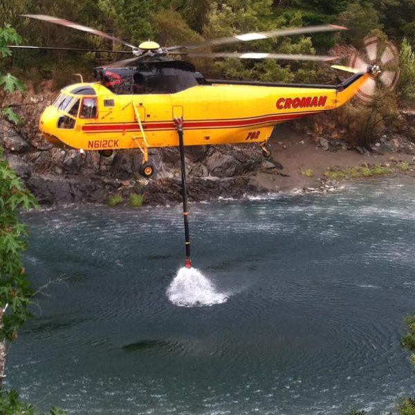
A helicopter collects water to fight the Coon Fire in the Gasquet Complex. [Photo provided by Matthew Parrott.]
[Note: The Sawtooth Fire which was discovered near the Gasquet Complex showed no heat during infrared photography of the area last night. The Horse Fire, which started the day before yesterday north of Shelter Cove, has been added below.]
As we update each incident until late evening, we’ll note the time the facts were posted so you can quickly see if there is something new. Look for the most recent general updates on the bottom but new information for individual fires is posted in the summaries below in blue. (Newest maps of the fires here.) Those that have expanded 20% or more will have their acreage in red bold type.
- Horse Fire (northeast of Shelter Cove): (Current as of 6 p.m.) 250 acres and 12% contained. Total Fire Personnel: 271. “Strong daytime winds off the ocean are influencing the fire behavior.” (More info here.)
- Fork Complex (Trinty Pines and north to Hayfork):(Current as of 7:30 p.m.) 36,285 acres burned and 62% contained. Structures Destroyed: Residences 8, other buildings 4, Firefighter injuries to date: 12, Total Personnel: 2002. “Strategic firing overnight on the south and southeast side of the Shiell Fire helped crews strengthen containment lines. A spot fire in the area is being suppressed.” (More info here.)
- Gasquet Fire: (Current as of 6:30 p.m.) 11,484 acres burned and 17% containment. Total Personnel: 778. Injuries: 18. “The southwest corner of the Coon Fire continues to back downhill to the South Fork of the Smith River in the Paradise Flat area. The current management strategy is to allow the fire to work down to the South Fork, which is being utilized as a natural containment line. A structure protection group continues to implement preparations in the community of Rock Creek, Paradise Flat and Tollefson Ranch. We are working closely with local and state agencies to make sure all residents have been advised of the existing structure protection plan. The Coon Fire has not crossed Deer Creek. Hand Crews and dozers have completed a secondary containment line on the ridge top south of Deer Creek.” (More info here)
- Humboldt Complex (Alderpoint and surroundings):(Current as of 7:15 p.m. on 19th) 4,883 acres burned and 100% contained. Structures Destroyed: 1 residence, 6 outbuildings. Firefighter injuries to date: 14, Total Personnel:1,392. “Currently, no additional fire growth is anticipated. (More info here)
- Mad River Complex (Ruth Lake and Surroundings) Now Combined with the Route Complex -see below: (More info here) Telephone number for the public information officer is 707-574-6289.
- Nickowitz Fire (northern Humboldt/southern Del Norte):(Current as of 6:40 p.m.) 4,770 acres and 53% contained. Total Personnel: 466. ” As expected, fire activity increased in some areas, but was generally favorable for meeting suppression objectives. Holding and securing the Soapstone Gulch area on the south flank is a priority for Thursday night, as is holding and securing the west flank. ” (More info here) Phone: 530-627-3246. N
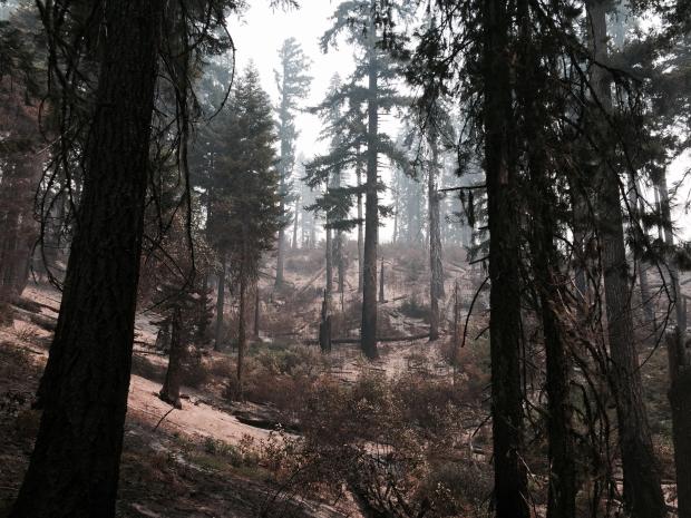
- River Complex:(Current as of 8:45 p.m.) 48,099 burned and 22% contained. Total Personnel: 675. “Tonight fire crews will continue activities in the Denny area and support holding the fire north of Forest Road 5N18. Even with the return of the inversion in the evening hours firefighters can expect active fire behavior supported by warmer temperatures and lower humidity.” (More info here.) Telephone number for the public information officer 530-276-8559. Estimated containment: October 01st, 2015

River Complex after the fire moved through. [Photo from InciWeb.]
- Route Complex (south and west of Hyampom and Buck Mt. area)Now Combined with the Mad River Complex:(Current as of 7:45 p.m.) 64,434 acres burned and 37% contained. Structures destroyed: 2 outbuildings. Total Personnel: 920. Injury: 1. “The Route and Mad River Complex and US Forest Service are hosting a public meeting on Friday, 21 August, at 5:30 p.m. at the Lamb Creek Christian Center on Highway 36 in Mad River–Johnson Fire (32,681 acres and 29% contained) After successful burnout operations earlier in the week the north end is in patrol and mop up status. The east side of the fire near Hyampom is in patrol status. …Continued burnout operations are planned for the south and west sides of the fire. Pickett Fire (10,935 acres, 78 percent contained) Debris continues to create a hazard on the highway 36 and is not yet safe for travel by the general public. Structure protection crews remain in the Forest Glen area. Lassic Fire (10,870 acres, 24 percent contained) Dozer line has been constructed on the western portion of the fire in coordination with Cal Fire to prevent any further spread to the west. The fire continues to spread in a south easterly direction, as expected. Structure defense remains in place in the Rutledge Area..” (More info here.) Telephone number for the public information officer is 707-574-6865.
- South Complex (north and west of Hyampom):(Current as of 7:50 p.m.) 22,807 acres burned and 50% containment. Personnel: 1062. “Fires on the South Complex became more active today as the wind picked up and the inversion lifted at about 5pm. Most activity observed was on the north western side of the Pattison Fire in the area northwest of Rays Peak and north of Forest Road 3N05. Dozer lines are in place to stop the forward spread, and crews will monitor and hold those lines overnight. Crews also continued to construct containment lines to the east and on the south side of the fire. A masticator working on the fire line caught fire at approximately 3pm this afternoon. The fire was contained to the masticator and did not spread to the surrounding wildland. No one was injured in the equipment fire.” (More info here)
—————
Here’s our tools to keep you abreast of what’s happening:
Newest Info: Next, the twitter feed near the bottom right of our home page is continuously updated with the latest tweets from Cal Fire, other local news organizations, the National Weather Service, etc.
Above that are two scanner feeds–one that will take you to Eureka/north coverage. The other that will take you to Eureka/south coverage.
Past Info: Reminder, at the bottom of this post under Earlier Chapters are links to our previous coverage. Much of it still very relevant. Particularly note our newest fire maps.
Don’t miss a post: In our right hand column is a subscribe box (for those accessing on mobiles, scroll down to the bottom and the box is just above recent posts.) Fill that out and a link to every story will appear in your email.
————————————
UPDATE 1:42 p.m.:
UPDATE 3:03 p.m.:
More photos and a map of the Horse Fire.
UPDATE 3:05 p.m.:
Cherokee citizen David Comingdeer is working the Mad River fire near Redding, CA, 16 days as a Dozer boss #wildfires pic.twitter.com/bu8x2hbB48
— CherokeeNation (@CherokeeNation) August 17, 2015
UPDATE 3:30 p.m.: The US Forest Service and the Trinity County Sheriff’s Office have issued the latest information for individuals in the areas affected by fire. The Forest Service is now allowing residents to travel more freely within the mandatory evacuation area of the River Complex between 9 a.m. and 2 p.m. and the Sheriff’s Office has updated their recommendations. Click here for more information.
UPDATE 5:20 p.m.:
Howland Hill Road is currently closed to the east of Stout Grove. Access from the west is still possible.
— Redwood N&S Parks (@RedwoodNPS) August 20, 2015
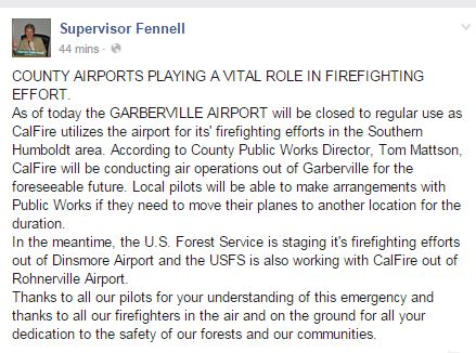
UPDATE 5:40 p.m.: Supervisor Fennell reports that Garberville Airport will be closed to regular use
UPDATE 6:15 p.m.: National Geographic loves the firefighters fighting our wildfires. We love the firefighters and the gritty photos featured in the article. Click here to see more.
UDPATE 7:40 p.m.: Wind whipped Lassic Fire rolls south and east. Click here for more.
Earlier Chapters:
- Traffic at a Standstill
- Willits Fires Caused by Rogue Lightning, More Lightning in Southeastern Trinity
- Day One: Lightning Fires
- Day Two:
- Brown Declares State of Emergency as Wildfires in Humboldt/Trinity Tax an Already Stressed System
- Lightning Fire Maps
- Day Three
- How Bad Are the Fires? Listen to This Short Video From Yesterday’s Fire Meeting
- Crews Firing Conley Creek Drainage Near Blocksburg
- Day Four (August 2)
- UPDATES on Trinity Fires From John Fenley Dist. Five Supervisor of That County
- Valuable Map Tool for Looking at the Fires
- How Bad Are the Fires? Listen to This Short Video From Yesterday’s Fire Meeting
- Trinity Evacuations
- Firefighter Injured
- New Fire Benbow Vineyard
- Smoke Update Trinity County 8/2
- Saving Highway 36
- New Road Closures in Trinity County Affect Evacuation Routes
- Southern Humboldt Fire Updates and Photos
- These Are The Detailed Fire Maps You’ve Been Waiting For!
- Day Five
- Can You Donate to Help Local Firefighters?
- Humboldt People Rock
- Gasquet Airfield Closed to Private Flights in Order to Accommodate Fire Traffic
- Good News, Blocksburg, Evacuation Advisory Lifted
- [UPDATE 6:05 p.m. Summary of Trinity Evacuations] Mandatory Evacuations Requested for Denny, Dailey, Hoboken and Bell Flat Areas
- Day Six
- We’ve Got Updated Fire Maps for You
- Air Quality Advisory
- KRCRTV Talks to Post Mountain Volunteer Firefighters About Residents’ Complaints
- Lots of New Fire Maps Now Available
- Day 7
- More Mandatory Evacuations in Trinity County
- Precautionary Evacutioons Issued for Humboldt County
- Overview of the Fires in Six Rivers National Forest
- Spot Fire Today: A Look at the Run Up Big Mountain
- Your Fire Maps 8/6/15
- Day 8 (August 6)
- Trinity County Sheriff Releases Updated Evacuation Information
- Sooo….Someone Stole Equipment From Firefighters……..
- Video From the Front Line of the Pine Fire
- Day 9
- YOUR FIRE MAPS 8/7/15
- Awww, Even Emerald Country Does Like Helicopters Now….
- [UPDATE 7 p.m.] Trinity County Sheriff Issues Updated Evacuation Information as of 8/7
- A Guide to Firefighters: Locals and Those From Far Away (Can You Believe We Have a Crew From Puerto Rico Here?)
- Weary Firefighters Bunking at HSU
- YOUR FIRE MAPS 8/8/15
- Day 10: Lightning Fires
- Smoke Conditions Across the Emerald Counties
- Latest Trinity County Evacuations 9 p.m. August 8
- Day 10 Lightning Fires
- YOUR FIRE MAPS 8/9/15
- Evacuation Updates From Trinity County on August 9
- Local Motorcycle Group Pitches in to Help Firefighters and Fire Victims, How You Can Donate
- YOUR FIRE MAPS 8/10/15
- Day 12: A Dozen Days After the Lightning Fires Began
- Aww! Three Generations of Firefighters on the Humboldt Complex
- Trinity County Evacuations as of August 10
- ‘Walking Where the Devil Dances:’ A Local Firefighter Writes About Fighting the Fires Day After Weary Day
- Lassic Fire, West of Ruth, Expanded Today
- Breaking News: Inmate Firefighter Seriously Injured on Humboldt Complex
- HCSO Would Like to Remind Humboldt of Precautionary Evacuations
- YOUR FIRE MAPS 8/11/15
- Evacuations and Road Information From Trinity County of August 11
- YOUR FIRE MAPS 8/12/15
- Day 13
- A Silent Witness: Dissecting a Fire
- Air Tanker Made Emergency Landing at Rohnerville Airport
- Day 14: Two Weeks After the Lightning Fires Started
- YOUR FIRE MAPS 8/13/15
- Day 15: Lightning Fires
- Unhealthy Air Found in Areas of Trinity County
- Trinity County Evacuations and Road Closure Information as of August 13
- Latest on Evacuations and Road Closures for Trinity County
- Day 16: Lightning Fires
- YOUR FIRE MAPS 8/15/15
- Day 17: Lighting Fires
- YOUR FIRE MAPS 8/15/15
- Lost Horses Seek Out Firefighters
- As the Fires Grow: Map Gifs of the River, Route, South and Mad River Complexes
- A Dubious Distinction: River Complex Now Largest This Year in California’s USFS Lands
- YOUR FIRE MAPS 8/16/15
- Day 18
- Current Information on Evacuations and Road Closures Per Trinity County Sheriff
- Day 19: Lightning Fires
- Lassic Fire Bursting Seams, Sheriff Evacuating Residences Now
- YOUR FIRE MAPS 8/18/15
- [UPDATE 10:20 p.m.] Day 20: Lightning Fires
- The Latest Information on Road Closures and Evacuations From Trinity County
- Day 21: Lightning Fires
- YOUR FIRE MAPS 8/19/15
- YOUR FIRE MAPS 8/20/15
Join the discussion! For rules visit: https://kymkemp.com/commenting-rules
Comments system how-to: https://wpdiscuz.com/community/postid/10599/
Cool , my wife and I didn’t even know that you actually used one of our photos because we’ve been camping. How cool. THANK YOU Kym.
Thank you for sharing it with us! Such a great shot!
[…] Day 22: Lightning Fires […]
[…] Day 22: Lightning Fires […]
[…] Day 22: Lightning Fires […]
[…] Day 22: Lightning Fires […]
[…] Day 22: Lightning Fires […]
[…] Day 22: Lightning Fires […]
[…] Day 22: Lightning Fires […]
[…] Day 22: Lightning Fires […]
[…] Day 22: Lightning Fires […]