
[UPDATE 9:03 p.m.] Lightning Fire Day 4
The Emerald Counties continue to battle some of the worst wildfires in our history. Nature isn’t helping though. Lots of lightning could be headed our way. Call 911 if you spot a blaze without fire crews on site.
Here’s what the National Weather Service tweeted this morning. (Stay updated with tweets from our area, including some of the latest news from the fires, on the tweet feed embedded in our site. Scroll down.)
Fire Weather Watch today. Stay safe out there. #cawx pic.twitter.com/07ja4H4QVg
— NWS Eureka (@NWSEureka) August 2, 2015
————————————————————————————-
Here’s what we know about the Humboldt Lightning Fires:
#HumboldtLightning[Update] 1200 acres, 10% contained, Blocksburg remains under evacuation advisory
— CAL FIRE HUU (@CALFIRE_HUU) August 2, 2015
Many of the residents of the little village of Blocksburg (see photo of the town below) spent the night watching the fires around them. Cal Fire had burned a backfire up Conley Creek to help protect the town.

Blocksburg in the haze of yesterday’s smoke. [Photo by Kristin Windbigler]
This morning I can see flames back behind the cemetery on the South Kneeland, but I think there are ground crews over there to fight them. I can also hear trees collapsing. I am hesitant to say the strategy worked because it’s been so hard to understand what’s going on the past few days, but I think the situation seems improved? Keep your fingers crossed for us.
Tony, the Raider-loving firefighter who is stationed in Blocksburg, was manning the pump on the backfiring done to protect the small town. Here’s what he tweeted,
Crews Firing Conley Creek Drainage Near Blocksburg Tonight, Do Not Be Alarmed
——————————————————————————————
The Rocky Fire in Lake County is expanding quickly. Mike McGuire, our State Senator, tweeted this,
#RockyFire Update: Huge expansion on Sat. Totals: 46k acres, 5% contained. 24 homes lost. 2k firefighters on scene. pic.twitter.com/9nRu7f9tsI
— Mike McGuire (@ilike_mike) August 2, 2015
———————————————————————————–
Here’s news from the Fork Fire in Trinity County:
There will be two public community meetings held today, 08/02/2015 in Hayfork and Hyampom.
The first public community meeting will be held at the Hayfork Community Church at 1:00pm. The church is located at 7450 Highway 3 in Hayfork.
The second public meeting will be held at Hyampom Volunteer Fire Hall in Hyampom at 4:00pm.
Go here for more on the Fork Fire
———————————————————–
Road Closures: Hwy 36 is closed from the Humboldt/Trinity County line to the Junction of State Route 3 in Susanville due to the wildfires.

Red triangles show where the roads are closed. [Information from Caltrans here]
Here’s what we know about the MENDOCINO Fires
#MendocinoLightningFires [update] throughout Mendocino County – 6 fires, 50 acres, 80% contained. 4-2 Cahto fire is 30 acres, 75% contained.
— CAL FIRE (@CAL_FIRE) August 2, 2015
UPDATE 9:05 a.m.:
Click on this link for an update on the Trinity County Fires.
UPDATE 9:50 a.m.:
Looking for ways to understand where the fires are located. Here’s an excellent map tool to look closely at where individual fires are in relation to landmarks and a very simple explanation of how to use it.
UPDATE 10:02 a.m.:
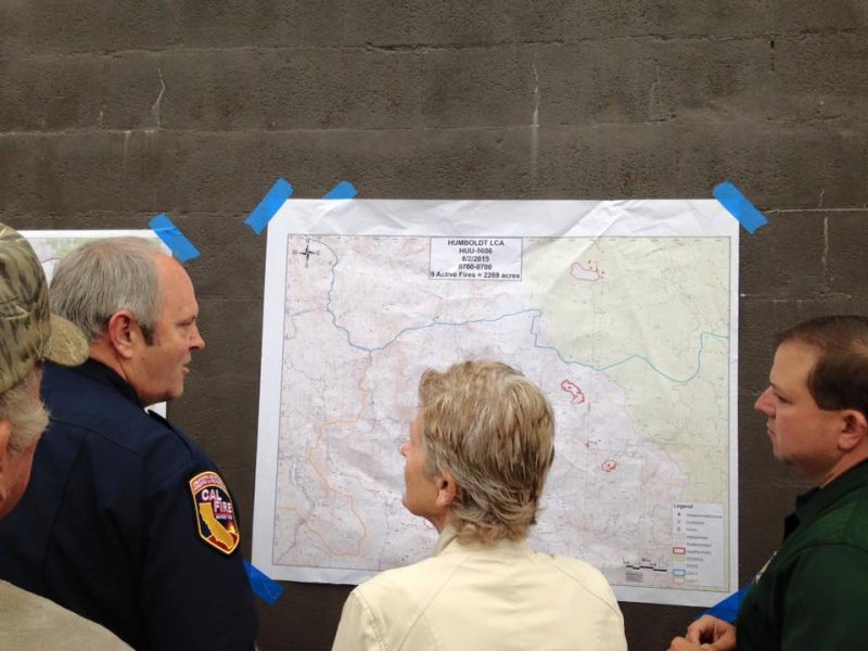
Terri Klemetson from KMUD attended this morning’s briefing at Blocksburg and shared with us the following information:
The Humboldt Lightning Complex fires burning in southern Humboldt have consumed approximately 2,300 acres, that’s according to Incident Commander Tom Nix as of this Sunday morning’s 7 am briefing.
Firefighters will continue to mop of dozens of fires that sparked during Thursday’s lightning event, meanwhile crews will attack 5 fires in the now-designated Branch I, those fires are burning between 30-100 acres each.
Meanwhile, Branch III, just a couple of miles north of Branch I, includes the 400 acre fire near Blocksburg. Calfire crews will continue to monitor the firing operation that was conducted Saturday night, keeping the fire within the perimeter control lines. The rest of Branch III is in patrol status, Calfire and local agency crews will be checking on all contained fires to make sure they are not re-igniting.
The Infrared Mapping located 4 hot spots from the North to South on the map they are: 173 acres north of Willow Draw Creek and south of the Eel River; 119 acres just north of and touching Winchester Ridge; 396 acres burning Hamner Flat east; and 166 acres burning near Steelhead Road.
The Blocksburg area is under an evacuation warning, if anyone needs shelter the Alderpoint Volunteer Fire Station is open to the community.

Now you can listen to the interview:
UPDATE 10:35 a.m.: Want to help? Here’s a page that has sprung up in support of the firefighter’s and the communities affected by the incidents:
UPDATE 10:57 a.m.: Click this link to watch Cal Fire describing the dire situation facing the town of Blocksburg yesterday.

UPDATE 1:01 p.m.: The Mad River Complex information has just been updated. The map is below. Click here to read.

UPDATE 1:16 p.m.: The latest information on the fires threatening Denny. The map is below.
Click here to read and see a larger version of the map.

UPDATE 2:09 p.m.: Scanner traffic says, two new fires. One unclear where. One in East Benbow. Bottom of Tooby Ranch. The fire crews are trying to get a helicopter. The Benbow is called 1-66 if you are listening on the scanner.
UPDATE 3:21 p.m.:
- Trinity Evacuations posted Click here.
- Firefighter injured. Click here.
- Smoke update for Trinity Co. Click here.
UPDATE 9:03 p.m.:
Press release provided by the Trinity County Sheriff:
As a result of extreme fire danger and evacuation orders in the Hyampom Area, if you are a resident of and are evacuating, you will need to leave the area using Hyampom Road into Hayfork as Road 60 & Road 47 are closed due to fire activity.

Earlier Chapters:
- Day One: Lightning Fires
- Day Two:
- Lightning Fire Maps
- Day Three
- How Bad Are the Fires? Listen to This Short Video From Yesterday’s Fire Meeting
- Crews Firing Conley Creek Drainage Near Blocksburg
- Day Four (August 2)
- UPDATES on Trinity Fires From John Fenley Dist. Five Supervisor of That County
- Valuable Map Tool for Looking at the Fires
- How Bad Are the Fires? Listen to This Short Video From Yesterday’s Fire Meeting
- Trinity Evacuations
- Firefighter Injured
- New Fire Benbow Vineyard
- Smoke Update Trinity County 8/2
- Saving Highway 36
- New Road Closures in Trinity County Affect Evacuation Routes
Join the discussion! For rules visit: https://kymkemp.com/commenting-rules
Comments system how-to: https://wpdiscuz.com/community/postid/10599/
Does anyone have links to DETAILED online maps? Something at the USGS quad level of the fires?
I need a map of the Underwood/burnt ranch area fires. My home is within a mile of these blazes, but I’m up in Washington for a wedding…… trying to figure when I need to bug out and get home…
Kym has them on her website. Limited, but excellent. The Mad River Complex isn’t featured, however.
Here’s the complex on the mapping tool I linked to in my other comment. If you look closely, you can see the long dark line of Ruth Lake and get an idea of where the fires are.
Try this: https://kymkemp.com/2015/08/02/valuable-map-tool-for-looking-at-the-fires/
Thanks, much better info.
I thought Susanville was southeast of Mt. Lassen on Highway 36?
I love Krisitin’s photo of the Blocksburg Church. Take care and be safe!
Ullr rover, I’ve been keeping eyes on InciWeb, Calfire, and YubaNet both on Facebook and online, but haven’t seen any detailed maps yet. 🙁
When you see any good detailed maps, send a link to [email protected]. We want to get the up for everyone. Meanwhile the best we have for the Humboldt Fires is this. https://kymkemp.com/2015/08/01/lightning-fire-maps/
Hi Kym, thanks for your *excellent* coverage of these fires.
There’s a valuable resource available, GeoMAC, from the U.S. Geological Survey for wildland fire support that includes satellite data, detailed topo map baselayers, and current fire perimeters (if mapped… most of these aren’t yet). The viewer requires a little bit of tweaking to provide you with useful data: you’ll need to 1) navigate to http://www.geomac.gov/viewer/viewer.shtml then 2) zoom in to our region then 3) add the MODIS thermal data layer using the tool on the left. That’ll yield an image that looks like this the image posted below.
Note that the MODIS thermal data is *satellite* data. It does not indicate exact areas burned, just pixels (and thus places) that appear hot to a satellite. Don’t make life or limb or property decisions based on this stuff, it’s a tool that is no substitute for on-the-ground safe observations by pro firefighters.
-Dan Barton
Map publication is not a priority for incident teams until they have reasonable intel and have begun to attend to the highest priority threats to life and property. With the magnitude of the current situation, and insufficient forces in place to begin to even size up the situation well, that won’t happen right away. If you’re not in the immediately affected area, stay put and let the firefighters work.
Great photo by Kristin Windbigler. Thanks for sharing it.
I’ve been going to wildlandfire.com and using the map that is on the homepage. If you click the banner at the bottom of the map it will bring up a full screen map. From there you can zoom in on your location and find real time (almost) information. In my area it shows a few red dots and I can click on them. A white information window pops up and on mine it says something like 1 of 3 and gives the name of the complex it is associated with. I then clicked the play button or right arrow and it went to 2 of 3. Click it again and it took me to 3 of 3. This page gives information about the specific dot that was clicked on. In my area it tells me that it was a hotspot located by satellite on such and such a time on such and such a date. There are 19 of them (red dots) in my area. I’ve been looking at this for a couple of days and the dots are moving around depending on the way the fire/hotspots are moving. Good luck.
Those red dots are useful for indicating what *was* on fire during the last MODIS satellite pass that’s been processed, but they’re not useful for indicating what is currently on fire or what previously burned.
[…] August 2: The fire coverage continues here. Earlier […]
Somewhere around 30 fire trucks have passed by my place heading out to Blocksburg area so far. Numerous pickup trucks with equipment, con camp trucks, semis hauling dozers . YAY !!
Yea!
YEAH!
I hear that the Steelhead fire has reached the river.
Stephanie, who lives out the Steelhead road, says that a fire line has been cut by the dozers at the Steelhead fire. No idea precisely what that means, and whether anyone is monitoring the fire line. That fire worries me more than the others, but really I don’t know enough to know if I should be worried about one of the other 6 fires in the Alderpoint area, instead.
Any more info on the steelhead fire? Has it jumped the river??
No
What supplies are needed at the Redway camp?
AP resident.Just took these pic facing out from the AP Legion Hall.There are occasional flames you can see. Plane and chopper flying around it,but no water drops. We need more resources out this way!!
Just got a call from Al Horn who was at the APVFD just now. They told him the Steelhead fire has jumped the river and is now burning on the south side as well as the north. That’s unfortunate because Alderpoint is on the south side of the river, too. So is the Rancho Sequoia subdivision. It is estimated that about 700 people live in “greater Alderpoint” all on the south side of the Eel River. Al said that he was told at the APVFD and state fire fighters were fighting the fire with some helicopter support. It will get dark here in about 90 minutes which will slow or stop the fight, I would think.
Here are some pics of the fire before it jumped to the south side of the Alderpoint area. Local fire crews where quick on the scene and we able to put it out. 1 fire truck still in the area just to monitor any other jumps or resparks. THANK YOU to the hard work and efforts of the local firefighters.👍🙌🚒
Thank you for the photo and the information!
A cat managed to cut a break down the hill part way. The line of flames you see in the pic is a back fire they lit. A chopper was able to dump water for a few hours today but it’s nowhere near out.
i’m so thankful that someone out there fighting the fires thinks that rancho sequoia and alderpoint folks are worth saving! thank you all so much for your efforts at getting the steelhead fire under control after it crossed the river.
Fire burning on north east side of pratt
Thank you!
North east side of pratt right now
Fire in blocksburg
And two more above blocksburg
Alderpoint Update: The spot fire on the south side of the river at Steelhead was quickly put out. It may have been collateral damage for a backfire they lit to keep the fire from reaching the river. APVFD and a helicopter, possibly others. I went up to Grower’s Leap, a good vantage point about 1 mile south of Alderpoint on the Alderpoint road to get a view of the Steelhead fire area. There were some other lookers too, but nothing but smoke visible. Bruce went out the Steelhead road and said he saw flames on the ridge across the river – the fire (1.43) is not out but the immediate menace to Alderpoint is over. I did not see any evacuatees from Blocksburg at the AP Fire Hall, but they are ready for any who show up. John Earp and Chief Robin Craig were there having dinner. Robin said the ALVFD was dedicated to protecting Alderpoint and were sticking around. That was very comforting. We are often on our own out here so it is nice to know that our own resources will be here when we need them. I keep thinking of that comment from Post Mountain.
ED Denson’s comment from 8:48 is very accurate. That little fire was at my place. Burning debris from the back burn floated over and sparked it. It took off and was growing incredibly fast. Thanks to the incredible action of friends, neighbors, APVFD, and CalFire (with inmate crew) it was extinguished very quickly but it could have been a disaster for our whole community. This mountain is bone dry. I can’t be sure, but I think things may be turning for the better on the Steelhead fire. I think they have a fire line containing it and a second nearby fire further downstream to the inside (north) of the big river bend. That whole mountain (north of river) seems to be on fire. Fortunately it seems to be burning understory much more than canopy. As long as it does not jump the river or the fire line, I think it will be contained to an uninhabited area. I can’t even express the depth of my gratitude to all those who helped us here. My thanks to them and to all who are helping with these fires. There are many heroes out there.
[…] Day Four (August 2) […]
[…] Day Four (August 2) […]
[…] Day Four (August 2) […]
[…] Day Four (August 2) […]
[…] Day Four (August 2) […]
[…] Day Four (August 2) […]
[…] Day Four (August 2) […]
[…] Day Four (August 2) […]
[…] Day Four (August 2) […]
[…] Day Four (August 2) […]
[…] Day Four (August 2) […]
[…] Day Four (August 2) […]
[…] Day Four (August 2) […]
[…] Day Four (August 2) […]
[…] Day Four (August 2) […]
[…] Day Four (August 2) […]
[…] Day Four (August 2) […]
[…] Day Four (August 2) […]
[…] Day Four (August 2) […]
[…] Day Four (August 2) […]
[…] Day Four (August 2) […]
[…] Day Four (August 2) […]